Home
States
Colorado
Connecticut
Maine
Massachusetts
New Hampshire
New York
Rhode Island
Utah
Vermont
View All
Lists
NE 4,000 Footers
NE 100 Highest
NH 4,000 Footers
NH 100 Highest
NH 52 With A View
NH Belknap Range
NH Ossipee 10
Links
Trail Conditions
Trip Log
Sunrises
Sunsets
About
|
Bigelow Mountain (Avery Peak), Bigelow Mountain (West Peak)
Wyman, ME, Dead River, ME
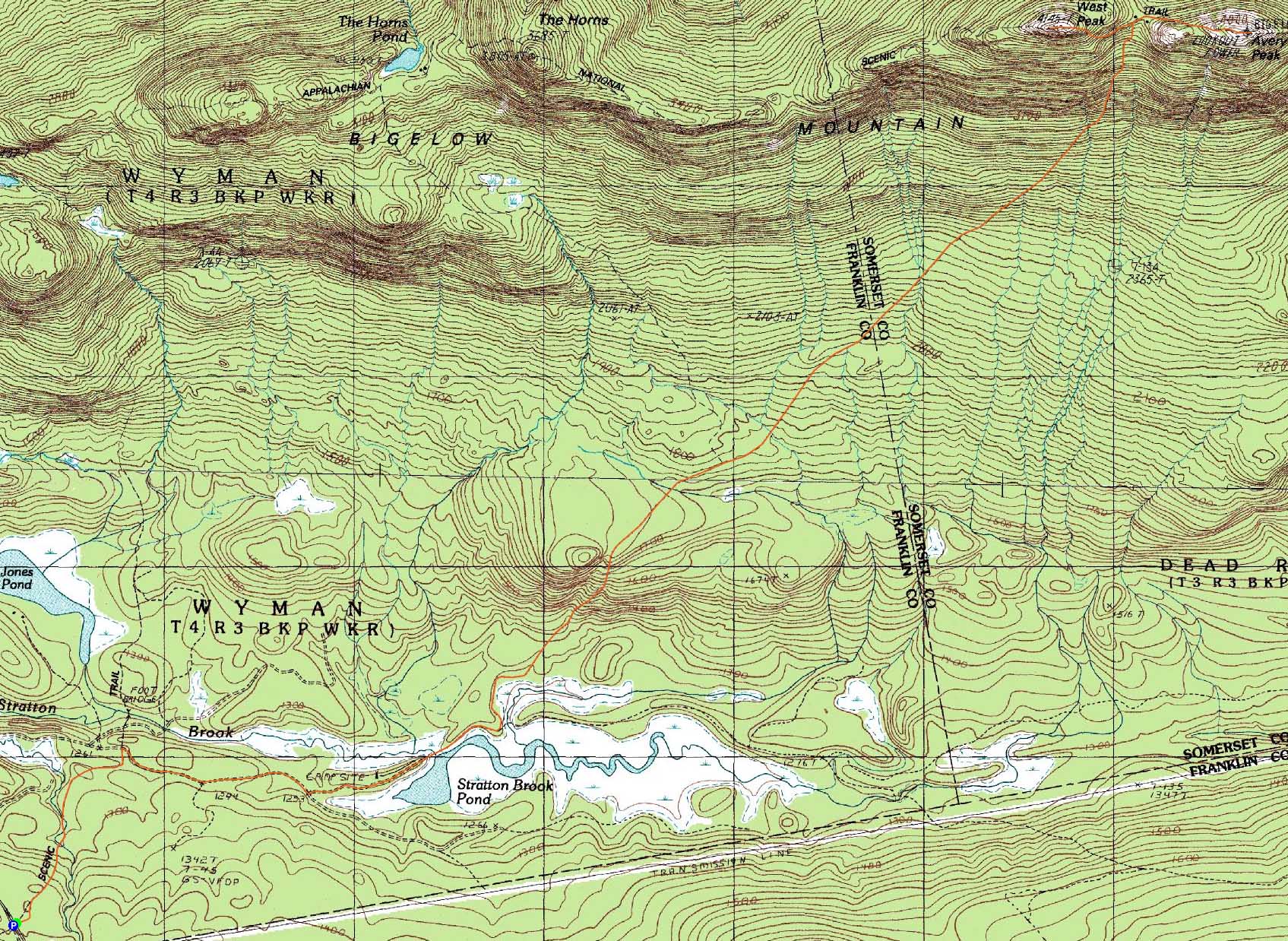
Trailheads, measurements, times, distances, and maps are all approximate and relative to the hike(s) as shown below.

Looking up the Fire Warden's Trail on the way to Avery Peak
Route: Appalachian Trail, Stratton Brook Pond Road, Fire Warden's Trail, Appalchian Trail, (Bigelow Mountain - Avery Peak), Appalchian Trail, (Bigelow Mountain - West Peak), Appalachian Trail, Fire Warden's Trail, Stratton Brook Pond Road, Appalachian Trail
After hiking almost exclusively in the White Mountains for some time, I was eager to get out of the area a bit. With an excellent forecast, I made a last minute decision to head up north for the night and get an early start the next morning.
Leaving Stratton, I drove to the Appalachian Trail in varying temperatures - below zero in the valleys and single digits elsewhere. After not finding much of a place to park at Stratton Brook Pond Road, I decided to park at the AT lot. In hindsight, we should have taken the extra 0.1 mile roadwalk, as it would have saved some vertical at the end of the day.
The Appalachian Trail provided a nice warm up as we worked our way to Stratton Brook Pond Road. We took a right onto the road (a snowmobile trail this time of year), and headed up it for awhile, eventually reaching a road junction. While the main snowmobile trail continued straight, we took a left and soon reached the small upper parking lot for the Fire Warden's Trail.
Now on the Fire Warden's Trail proper, we soon reached the end of recently used trail. While there was only a few more inches of new snow on top of the previous footbed, it was light trailbreaking nonetheless. Eventually reaching the steeps of the trail, we were dealing with a bit more snow as we climbed. The views were spectacular as Avery Peak loomed in front of us and Sugarloaf watched our backs.
Reaching the col in far from impressive time, we could see that the Appalachian Trail was not broken out. A pipe dream was to head over to the Horns later in the day - at this point, though, it would be a hustle to get back to the road before sunset.
Reaching treeline on Avery Peak, we had to do some trail finding - the vast amounts of snow on the spruce trees and cairns made them all look the same. Relying on memory, we were able to make our way to the summit without falling into any spruce traps. The views from here were tremendous - not only were the peaks to the south quite a sight, but Katahdin as clearly visible to our northeast. While we were tempted to have lunch while taking in these views, the winds were just strong enough to convince us to eat at the col.
After lunch, we had our toughest trailbreaking of the day on our way to West Peak. While some folks had likely been to Avery Peak in recent weeks, there was no sign of any traffic to West Peak. Thus, we found ourselves breaking out anywhere from 1-3 feet of powder. Fortunately, we were out of the wind for this ascent, making things pretty tame. In addition, the trailfinding above treeline was a bit easier here as well.
The views from West Peak were better than Avery - not only did Katahdin seem wicked close, but the Presidentials were also fairly easily seen. Dropping back down slightly, we found a nice place to sit out of the wind and take in the views to the south.
The walk out was a bit long, considering the miles of fairly flat terrain we had to cover. The last 0.9 mile of the Appalachian Trail was a butt kicker with its ups and downs. Nonetheless, it was a very worthwhile hike.
| Hike Ratings |
|
Getting To Trailhead: |
Easy |
| Destination: |
Bigelow Mountain (Avery Peak) |
|
Length: |
Difficult |
|
Steepness: |
Difficult |
|
Navigation: |
Difficult |
|
Views: |
Excellent |
|
Crowds: |
Minimal |
| Destination: |
Bigelow Mountain (West Peak) |
|
Length: |
Difficult |
|
Steepness: |
Difficult |
|
Navigation: |
Difficult |
|
Views: |
Excellent |
|
Crowds: |
Minimal |
|
| Hike Stats |
|
Date Hiked: |
Saturday, January 23, 2010 |
| Hike Commenced: |
7:06 AM |
| Parking Elevation: |
1,390' |
| Destination: |
Bigelow Mountain (Avery Peak) |
| Ascent Commenced: |
7:06 AM |
| Summit Reached: |
11:49 AM |
| Time Elapsed: |
04:43 |
| Trailhead Elevation: |
1,390' |
| Summit Elevation: |
4,088' |
| Vertical Gain: |
3,013' |
| Destination: |
Bigelow Mountain (West Peak) |
| Ascent Commenced: |
11:57 AM |
| Summit Reached: |
12:47 PM |
| Time Elapsed: |
00:50 |
| Trailhead Elevation: |
4,088' |
| Summit Elevation: |
4,145' |
| Distance: |
0.7 mile |
| Vertical Gain: |
370' |
|
|
| Hike Ended: |
4:10 PM |
| Hike Time Elapsed: |
09:04 |
| Hike Vertical Gain: |
3,663' |
|

The Appalachian Trail trailhead on Route 27

Looking up the Appalachian Trail on the way to Avery Peak

Looking at Flagstaff Lake from Avery Peak

The Appalachian Trail on the way to Bigelow Mountain's West Peak

The Appalachian Trail on the way to Bigelow Mountain's West Peak

Looking at Mt. Katahdin from Bigelow Mountain's West Peak


Directions to trailhead: Take Route 27 northwest from the entrance to Sugarloaf USA ski area. Stratton Brook Pond Road is closed beyond the first hosues in winter, making the Fire Warden's Trail harder to access. The Appalachian Trail eventually crosses the road on a downhill section. There is a parking lot on the left (only a small portion plowed in winter 2009-2010). The Appalachian Trail continues across the road (right), leading toward Stratton Brook Pond Road and eventually the Fire Warden's Trail.
Back to Bigelow Mountain - Avery Peak Profile
Back to Bigelow Mountain - West Peak Profile
|