Home
States
Colorado
Connecticut
Maine
Massachusetts
New Hampshire
New York
Rhode Island
Utah
Vermont
View All
Lists
NE 4,000 Footers
NE 100 Highest
NH 4,000 Footers
NH 100 Highest
NH 52 With A View
NH Belknap Range
NH Ossipee 10
Links
Trail Conditions
Trip Log
Sunrises
Sunsets
About
|
Black Mountain, Rumford Whitecap
Rumford, ME
Trailheads, measurements, times, distances, and maps are all approximate and relative to the hike(s) as shown below.

Looking down the Allagash ski trail
Route: Ski trails, herd path, access road, (Black Mountain), access road, Black and White Trail, Orange Trail, (Whitecap Mountain), Orange Trail
Ski trails up Black Mountain of Maine were still well endowed with snow (area could easily still be open if not for the lack of skiers this time of year). We opted to snowshoe, but one could boot the packed trails as well.
If standing at the top ramp of the triple chairlift with one's back to the ski area, head toward the light pole at about 1:00 (you'll see some towers in the distance). You'll initially start on a quasi-logging road. A few dozen feet up it, bear left onto a herd path (some blue flagging tape) and head toward the towers. This will lead to the closest tower. One can follow the access road from it initially uphill, then downhill (a bigger tower is seen in the medium distance) to another road (take a left onto it). At the end of this road, just beyond the big tower, is an excellent viewpoint ranging from the Presidentials to some of the Rangeley area peaks.
Back at the first tower, the new Black and White Trail starts just above it (fresh white blazes). The trail meanders down to the col and the helicopter rendezvous landing site. From there, it really meanders, eventually swinging south of Whitecap and joining the Orange Trail near the first ledges that trail reaches. The distance between the lower Black Mountain tower and the Orange Trail was probably about 5 miles (direct bushwhack peak to peak would have probably been closer to 1 mile).
There was no sign of recent traffic on the Black and White Trail. Snowpack was 1-3 feet deep, so snowshoes were ideal.
Orange Trail was getting a little sloppy, as it was a mix of spring snow, some ice/frozen granular, bare ledge, and running water. May be easiest to do this trail in light traction at the moment.
| Hike Ratings |
|
Getting To Trailhead: |
Easy |
| Destination: |
Black Mountain |
|
Length: |
Moderate |
|
Steepness: |
Difficult |
|
Navigation: |
Difficult |
|
Views: |
Excellent |
|
Crowds: |
Minimal |
| Destination: |
Whitecap Mountain |
|
Length: |
Moderate |
|
Steepness: |
Moderate |
|
Navigation: |
Moderate |
|
Views: |
Excellent |
|
Crowds: |
Minimal |
|
| Hike Stats |
|
Date Hiked: |
Sunday, April 6, 2013 |
| Parking Elevation: |
960' |
| Destination: |
Black Mountain |
| Time Elapsed: |
01:23 |
| Trailhead Elevation: |
960' |
| Summit Elevation: |
2,350' |
| Vertical Gain: |
1,455' |
| Destination: |
Whitecap Mountain |
| Time Elapsed: |
02:52 |
| Trailhead Elevation: |
2,350' |
| Summit Elevation: |
2,214' |
| Vertical Gain: |
1,114' |
|
|
| Hike Time Elapsed: |
05:54 |
| Hike Vertical Gain: |
2,569' |
|

Looking up the ski trails at Black Mountain Ski Area

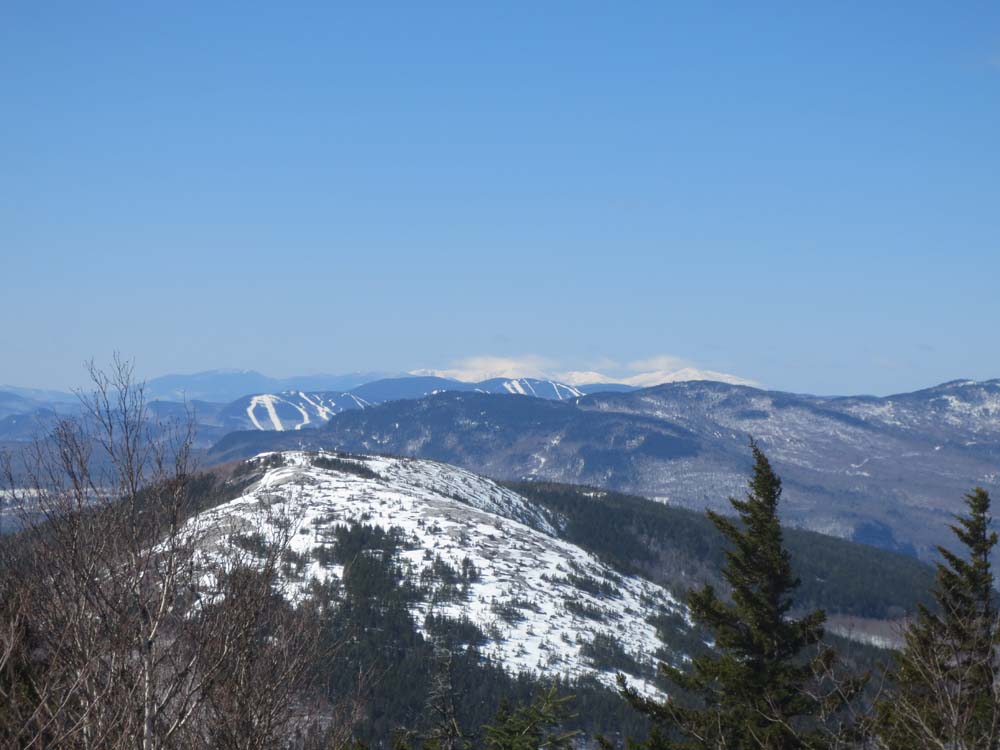
Looking at Whitecap Mountain, Sunday River, and the Presidentials from near the summit of Black Mountain

The Black and White Trail on the way to Whitecap Mountain

Looking northeast from Whitecap Mountain


Directions to trailhead: To get to the Orange Trail trailhead, take Route 5 north from Bethel. Shortly after leaving US 2, take a right onto Andover Road, crossing over Ellis River. Shortly thereafter, take a left onto East Andover Road. The Rumford Whitecap parking area will be on the left a few seconds thereafter and the Orange Trail trailhead on the right. Black Mountain of Maine ski area is located outside of Rumford
Back to Black Mountain Profile
Back to Whitecap Mountain Profile
|