Home
States
Colorado
Connecticut
Maine
Massachusetts
New Hampshire
New York
Rhode Island
Utah
Vermont
View All
Lists
NE 4,000 Footers
NE 100 Highest
NH 4,000 Footers
NH 100 Highest
NH 52 With A View
NH Belknap Range
NH Ossipee 10
Links
Trail Conditions
Trip Log
Sunrises
Sunsets
About
|
Mt. Abraham, Spaulding Mountain, Sugarloaf Mountain
Carrabassett Valley, ME, Mt. Abraham, ME
Trailheads, measurements, times, distances, and maps are all approximate and relative to the hike(s) as shown below.

Looking up the Fire Warden's Trail
Route: Fire Warden's Trail, (Mt. Abraham), Mt. Abraham Side Trail, Appalachian Trail, Spaulding Mountain Side Trail, (Spaulding Mountain), Spaulding Mountain Side Trail, Appalachian Trail, Sugarloaf Side Trail, (Sugarloaf Mountain), ski trails
The Fire Warden's Trail had been rerouted in three places - twice below the logging road crossing and also just below the recently-burned-down fire warden's cabin.
The views were excellent from Mt. Abraham. Though limited, the directional views from Spaulding were good as well. Cloudy later in the day, the views were quite as crisp from Sugarloaf.
| Hike Ratings |
|
Getting To Trailhead: |
Difficult |
| Destination: |
Mt. Abraham |
|
Length: |
Moderate |
|
Steepness: |
Difficult |
|
Navigation: |
Easy |
|
Views: |
Excellent |
|
Crowds: |
Moderate |
| Destination: |
Spaulding Mountain |
|
Length: |
Moderate |
|
Steepness: |
Difficult |
|
Navigation: |
Easy |
|
Views: |
Excellent |
|
Crowds: |
Minimal |
| Destination: |
Sugarloaf Mountain |
|
Length: |
Difficult |
|
Steepness: |
Moderate |
|
Navigation: |
Easy |
|
Views: |
Excellent |
|
Crowds: |
Minimal |
|
| Hike Stats |
|
Date Hiked: |
Sunday, July 10, 2011 |
| Time to Trailhead: |
00:14 |
| Parking Elevation: |
988' |
| Destination: |
Mt. Abraham |
| Time Elapsed: |
02:55 |
| Trailhead Elevation: |
1,163' |
| Summit Elevation: |
4,050' |
| Vertical Gain: |
3,107' |
| Destination: |
Spaulding Mountain |
| Time Elapsed: |
01:49 |
| Trailhead Elevation: |
4,050' |
| Summit Elevation: |
4,010' |
| Distance: |
3.7 miles |
| Vertical Gain: |
1,060' |
| Destination: |
Sugarloaf Mountain |
| Time Elapsed: |
01:41 |
| Trailhead Elevation: |
4,010' |
| Summit Elevation: |
4,250' |
| Distance: |
2.8 miles |
| Vertical Gain: |
585' |
|
|
| Hike Time Elapsed: |
8:38 |
| Hike Vertical Gain: |
4,927' |
|

The Appalachian Trail crossing on Caribou Valley Road

The remains of the recently burned Fire Warden's cabin

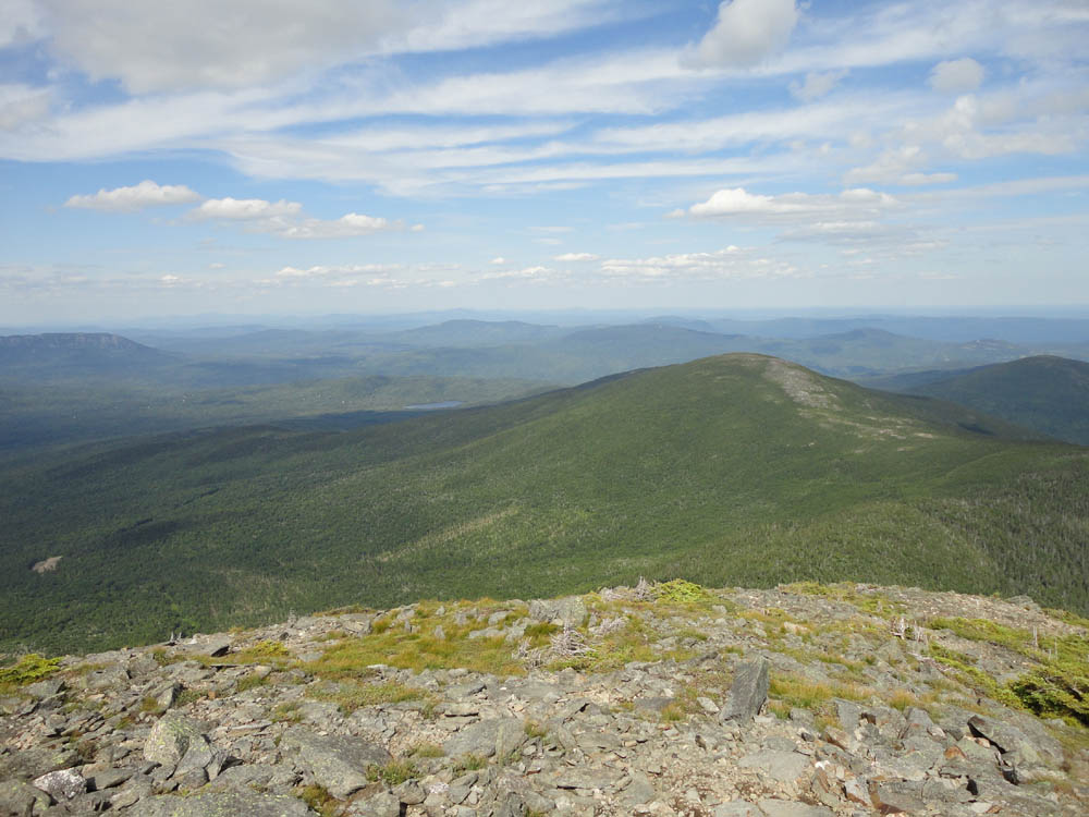
Spaulding and Sugarloaf as seen from Mt. Abraham

The Mt. Abraham Side Trail on the way to Spaulding Mountain

The Saddlebacks as seen from Spaulding Mountain

The Sugarloaf Side Trail on the way to Sugarloaf Mountain

Burnt Hill as seen from Sugarloaf Mountain


Directions to trailhead: To get to Sugarloaf ski area, take Route 16 to Carrabassett Valley, then follow the signs to the Sugarloaf access road and base area. To get to the Fire Warden's Trail, take Route 16 South toward Kingfield. Take a right onto West Kingfield Road. Continue on this road, going straight through junctions. It will soon become Rapid Stream Road, which is dirt. A few miles up the road, there will be a four way intersection. Take a left, cross two wood bridges (in early summer 2011, one of these bridges was heavily damaged, resulting in unsafe vehicular passage), then bear right at the next junction. Continue up this road, which will soon come to a crossroad, with the The Firewarden's Trail trailhead directly ahead.
Back to Mt. Abraham Profile
Back to Spaulding Mountain Profile
Back to Sugarloaf Mountain Profile
|