Home
States
Colorado
Connecticut
Maine
Massachusetts
New Hampshire
New York
Rhode Island
Utah
Vermont
View All
Lists
NE 4,000 Footers
NE 100 Highest
NH 4,000 Footers
NH 100 Highest
NH 52 With A View
NH Belknap Range
NH Ossipee 10
Links
Trail Conditions
Trip Log
Sunrises
Sunsets
About
|
Mt. Toby
Sunderland, MA
Trailheads, measurements, times, distances, and maps are all approximate and relative to the hike(s) as shown below.

Road to Mt. Toby summit
Mt. Toby is one of many nice, moderate hikes near the Amherst area. While the views from the ground at the summit aren't that great, a quick climb up the firetower reveals a panorama.
| Hike Ratings |
|
Getting To Trailhead: |
Easy |
| Destination: |
Mt. Toby |
|
Length: |
Moderate |
|
Steepness: |
Moderate |
|
Navigation: |
Easy |
|
Views: |
Excellent |
|
Crowds: |
Moderate to Heavy |
|
| Hike Stats |
|
Date Hiked: |
Sunday, May 7, 2006 |
| Parking Elevation: |
410' |
| Destination: |
Mt. Toby |
| Summit Reached: |
1:22 PM |
| Trailhead Elevation: |
405' |
| Summit Elevation: |
1269' |
| Vertical Gain: |
904' |
| Hike Vertical Gain: |
944' |
|
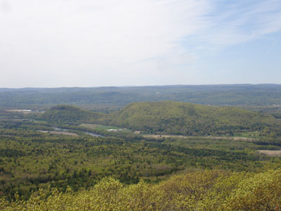
Mt. Toby summit view (looking southwest)


Directions to trailhead: Take Route 47 to Reservation Road. Parking at trail map.
Back to Mt. Toby Profile
|

