Home
States
Colorado
Connecticut
Maine
Massachusetts
New Hampshire
New York
Rhode Island
Utah
Vermont
View All
Lists
NE 4,000 Footers
NE 100 Highest
NH 4,000 Footers
NH 100 Highest
NH 52 With A View
NH Belknap Range
NH Ossipee 10
Links
Trail Conditions
Trip Log
Sunrises
Sunsets
About
|
Bald Mountain
Albany, NH
Trailheads, measurements, times, distances, and maps are all approximate and relative to the hike(s) as shown below.
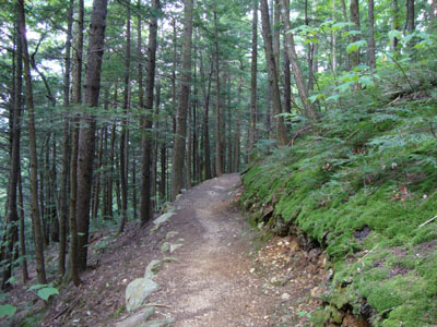
Looking up the Weetamoo Trail
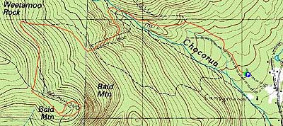
Route: Piper Trail, Weetamoo Trail, Hammond Trail, bushwhack, (Bald Mountain), bushwhack, Hammond Trail, Weetamoo Trail, Piper Trail
Though the forecast was looking good a day or two in advance, the updated morning forecast was mediocre at best - instead of mostly sunny, mostly cloud with a chance of rain. As I drove to the Piper Trail trailhead, it rained briefly - arg.
Starting on the Piper Trail, the sky seemed to be clearing a bit. After the gentle walk to the Weetamoo Trail junction, the grades stayed tame as the trail approached the water crossing. While the crossing was rock hoppable (though a bit tricky in new boots), it could be tough in high water situations.
After awhile, I thought I saw what was Weetamoo Rock on my left. I soon realized I was mistaken, as I passed a very large rock on my right - quite a sight to see, though some clearing might enhance things a bit more.
Reaching the Hammond Trail junction, I was pleased to observe that the Weetamoo Trail had never been steep or suffered from bad footing - not a bad trail.
After a short walk downhill on the Hammond Trail, I reached the height of land of Bald Mountain and bushwhacked my way to the summit. From there, I pushed over to the view ledges, where the scenery was phenomenal. Doing a bit more exploring, I dropped down maybe a dozen vertical feet and found even more impressive views. All told, I could see, from multiple ledges, Chocorua to the Ossipees and everything in between (clockwise, west to south). How this area does not have a trail to it, I do not know.
The return trip was non-eventful, other than the typical discomfort from breaking in a new pair of boots.
| Hike Ratings |
|
Getting To Trailhead: |
Easy |
| Destination: |
Bald Mountain |
|
Length: |
Moderate |
|
Steepness: |
Moderate |
|
Navigation: |
Difficult |
|
Views: |
Excellent |
|
Crowds: |
Minimal |
|
| Hike Stats |
|
Date Hiked: |
Wednesday, August 26, 2009 |
| Hike Commenced: |
3:45 PM |
| Parking Elevation: |
780' |
| Destination: |
Bald Mountain |
| Ascent Commenced: |
3:45 PM |
| Summit Reached: |
4:55 PM |
| Time Elapsed: |
01:10 |
| Trailhead Elevation: |
780' |
| Summit Elevation: |
2,140' |
| Vertical Gain: |
1,480' |
|
|
| Hike Ended: |
6:38 PM |
| Hike Time Elapsed: |
02:53 |
| Hike Vertical Gain: |
1,660' |
|
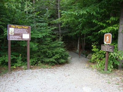
The Piper Trail trailhead
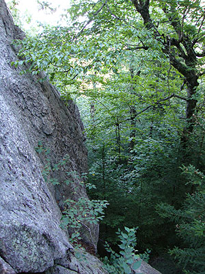
The lower half of Weetamoo Rock
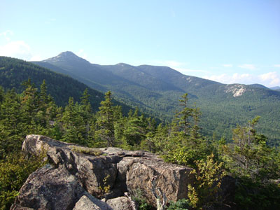
Looking at Mt. Chocorua, the Three Sisters, and Carter Ledge from the Bald Mountain ledges

Directions to trailhead: Take Route 16 North from Tamworth. The Piper Trail WMNF sign is on the left, immediately after a general store. The WMNF fee parking area is about a minute or off Route 16. The Piper Trail trailhead is at the back corner of the parking lot.
Back to Bald Mountain Profile
|


