Home
States
Colorado
Connecticut
Maine
Massachusetts
New Hampshire
New York
Rhode Island
Utah
Vermont
View All
Lists
NE 4,000 Footers
NE 100 Highest
NH 4,000 Footers
NH 100 Highest
NH 52 With A View
NH Belknap Range
NH Ossipee 10
Links
Trail Conditions
Trip Log
Sunrises
Sunsets
About
|
Bayle Mountain
Ossipee, NH
Trailheads, measurements, times, distances, and maps are all approximate and relative to the hike(s) as shown below.
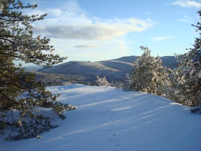
Looking down the trail to Bayle Mountain near the summit
Route: Unknown snowmobile trail, red blazed trail, (Bayle Mountain), red blazed trail, unknown snowmobile trail
Once the clouds associated with the great ice storm of 2008 started to depart, I quickly gathered up my gear and took the rest of the afternoon off from work so that I could begin the great clean up of 2008.
Since branches and trees were still falling, I was looking to do trail maintenance somewhere where I could safely park. My initial target was Bald Knob via 171. Only a few minutes into that hike, however, I discovered that the low point of the trail was submerged in a bunch of water. Not wanting to have to wade across, I decided to find something else that would fit within my window of daylight. Though I wasn't looking forward to parking under trees, Bayle Mountain was nonetheless the best fit otherwise (short enough, and no real water crossings).
The snowmobile trail from Marble Road was in rough shape - lots of branches down and trees leaning onto it. On top of that, the crust wasn't quite strong enough to support me, so I ended up lightly postholing as I made my way to the Bayle Mountain trailhead.
The trail had anywhere from an inch to perhaps 8" of snow on it, packed down pretty well with an icy crust. Due to the ice, there were plenty of obstructions.
I was a bit surprised to see how much water had accumulated in the little col just below the summit - the worst I've seen it was with about 6" of water immediately after days of rain in the summer. This time, it was a mini pond - fortunately, I was able to get around it without much trouble by bushwhacking just a bit to the right (ascending).
I was able to clean up most of the downed branches on the way up and make it to the summit, barebootedly (though just barely, as the summit area was icy), in time to see some great views. Particularly neat was the isolated fog rising to the south and east.
For the descent, I focussed on the stuff that needed to be cut with the saw. Fortunately, I was able to clear the trail of all branches and trees down (and there were plenty!) in time to arrive back at the trailhead by sunset.
| Hike Ratings |
|
Getting To Trailhead: |
Moderate |
| Destination: |
Bayle Mountain |
|
Length: |
Moderate |
|
Steepness: |
Difficult |
|
Navigation: |
Easy |
|
Views: |
Excellent |
|
Crowds: |
Minimal |
|
| Hike Stats |
|
Date Hiked: |
Friday, December 12, 2008 |
| Hike Commenced: |
2:00 PM |
| Parking Elevation: |
1,005' |
| Destination: |
Bayle Mountain |
| Ascent Commenced: |
2:20 PM |
| Summit Reached: |
3:01 PM |
| Time Elapsed: |
00:41 |
| Trailhead Elevation: |
1,100' |
| Summit Elevation: |
1,853' |
| Vertical Gain: |
763' |
|
|
| Hike Ended: |
4:15 PM |
| Hike Time Elapsed: |
02:15 |
| Hike Vertical Gain: |
1,028' |
|
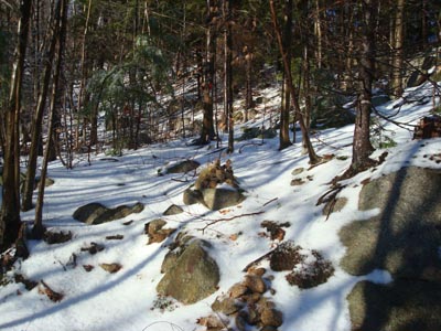
The trailhead to the trail to the Bayle Mountain summit
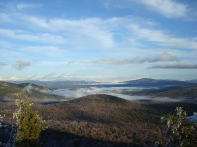
Looking at Ossipee Lake from the Bayle Mountain summit
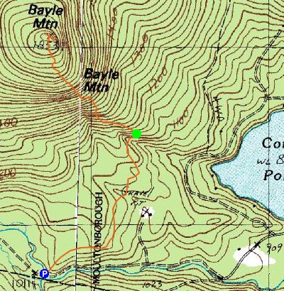

Directions to trailhead: From Route 16 South in West Ossipee, take a right onto Pine Hill Road. At the end of Pine Hill Road, take a right onto Ossipee Mountain Road. Shortly after passing Connor Pond, bear right onto Marble Road. Just before a narrow wooden bridge, the snowmobile trail enters on the right (and then leaves on the left after the bridge), marked slightly off the road with an orange gate. Park here without blocking the roads or trails, and head up the snowmobile trail on the right. The trailhead will be about 10-20 minutes up this snowmobile trail, to the left at a height of land on a curve in the road, marked with a cairn.
Back to Bayle Mountain Profile
|

