Home
States
Colorado
Connecticut
Maine
Massachusetts
New Hampshire
New York
Rhode Island
Utah
Vermont
View All
Lists
NE 4,000 Footers
NE 100 Highest
NH 4,000 Footers
NH 100 Highest
NH 52 With A View
NH Belknap Range
NH Ossipee 10
Links
Trail Conditions
Trip Log
Sunrises
Sunsets
About
|
Bean Mountain, Kennedy Hill
Lempster, NH
Trailheads, measurements, times, distances, and maps are all approximate and relative to the hike(s) as shown below.

Open woods on the way to Bean Mountain
Route: Bushwhacks, access road, logging roads
About a foot or so of snow, including an inch or two overnight. Snowshoes a must.
From the gate, we crossed the road and bushwhacked in open woods up to Bean, which had excellent views from ledges near its highpoint. Being that there is a windfarm on the same ridge, it sounded like bushwhacking around an airport runway. Some evidence of a trail on the ledges, but hard to tell with snow on the ground.
We then popped out on the windfarm access road (the southern stretch was plowed), and followed this over the ridge toward era Kennedy Hill (not plowed). It looks like the second from last turbine had a bit of an issue, as there was a blade on the ground with a gaping hole in it (turbine had already been repaired). From the top turbine, we bushwhacked to the wooded peak of era Kennedy Hill, where fortunately no Kennedys had had any drunken car, Jeep, golf, skiing, or flying accidents.
From there, we descended southeast, soon hitting less than pleasant logging regrowth, as well as a swamp. In hindsight, we probably would have doubled back south along the ridge, then dropped more directly.
| Hike Ratings |
|
Getting To Trailhead: |
Easy |
| Destination: |
Bean Mountain |
|
Length: |
Moderate |
|
Steepness: |
Moderate |
|
Navigation: |
Difficult |
|
Views: |
Excellent |
|
Crowds: |
Minimal |
| Destination: |
Kennedy Hill |
|
Length: |
Moderate |
|
Steepness: |
Moderate |
|
Navigation: |
Difficult |
|
Views: |
Minimal |
|
Crowds: |
Minimal |
|
| Hike Stats |
|
Date Hiked: |
Friday, November 28, 2010 |
| Parking Elevation: |
1,601' |
| Destination: |
Bean Mountain |
| Time Elapsed: |
01:11 |
| Trailhead Elevation: |
1,601' |
| Summit Elevation: |
2,326' |
| Vertical Gain: |
745' |
| Destination: |
Kennedy Hill |
| Time Elapsed: |
01:48 |
| Trailhead Elevation: |
2,326' |
| Summit Elevation: |
2,159' |
| Vertical Gain: |
329' |
|
|
| Hike Time Elapsed: |
04:48 |
| Hike Vertical Gain: |
1,114' |
|

Entering the woods across from the Pillsbury State Park entrance

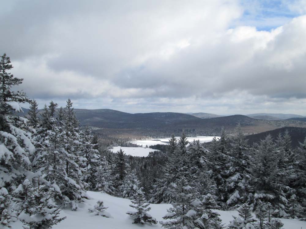
Looking east from near the Bean Mountain summit

The access road between the peaks

Looking at Okemo from near the summit of Kennedy Hill


Directions to trailhead: From Route 10 in Goshen, take Route 31 southeast to Pillsbury State Park. In winter, there is limited room to park near the closed gate.
Back to Bean Mountain Profile
Back to Kennedy Hill Profile
|