Home
States
Colorado
Connecticut
Maine
Massachusetts
New Hampshire
New York
Rhode Island
Utah
Vermont
View All
Lists
NE 4,000 Footers
NE 100 Highest
NH 4,000 Footers
NH 100 Highest
NH 52 With A View
NH Belknap Range
NH Ossipee 10
Links
Trail Conditions
Trip Log
Sunrises
Sunsets
About
|
Gap Mountain (North Peak), Gap Mountain (South Peak)
Jaffrey, NH, Troy, NH
Trailheads, measurements, times, distances, and maps are all approximate and relative to the hike(s) as shown below.

The Metacomet-Monadnock Trail near the north peak
Route: Roadwalk, Metacomet Monadnock Trail, (Gap Mountain North Peak), herd path, (Gap Mountain South Peak), herd path, Metacomet Monadnock Trail, parking lot spur trail
For the ascent, I walked back down the parking lot access road, then up Old Mill Road to the Metacomet-Monadnock Trail junction (followed the trail kosher on the return trip - I think taking the short roadwalk is a little easier).
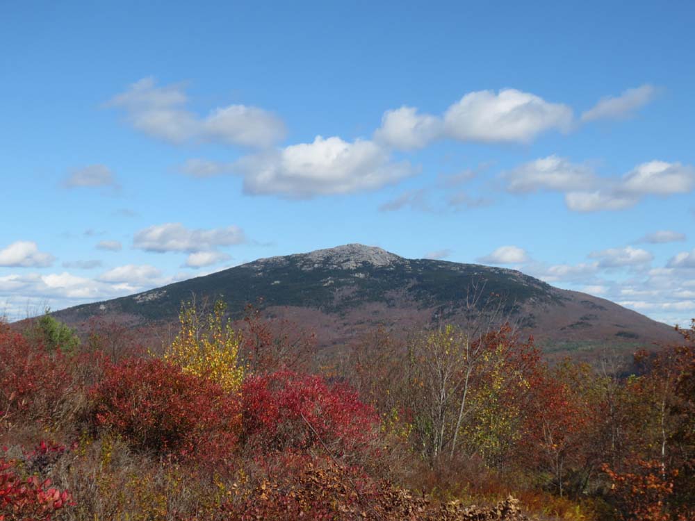
Mild to moderate grades up to the false peak and then North Peak. Fantastic views in all directions from the North Peak.
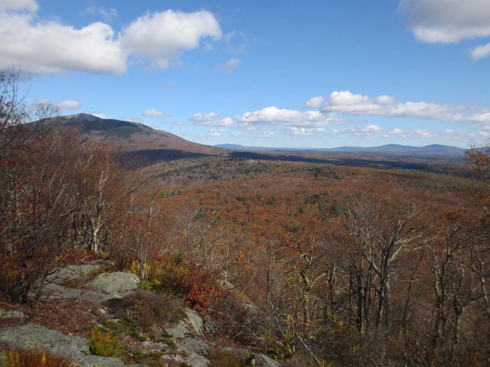
Toward the west side of the ridge, near where the M&M trail drops off, a herd path heads to the South Peak (also the highpoint). It starts near a view ledge, drops into the gap/col a little to the west, then climbs up to the cairn. It's not marked, but the footbed is generally obvious, as are the years of brushing cuts. From the big cairn, if you push maybe 50 feet east, you'll pop out onto a very nice view ledge (nowhere near as nice as the north peak, but otherwise great views ranging from Monadnock to the Pack Monadnocks).
The foliage is well past peak, but there were some nice patches of color.
| Hike Ratings |
|
Getting To Trailhead: |
Easy |
| Destination: |
Gap Mountain (North Peak) |
|
Length: |
Moderate |
|
Steepness: |
Moderate |
|
Navigation: |
Easy |
|
Views: |
Excellent |
|
Crowds: |
Moderate |
| Destination: |
Gap Mountain (South Peak) |
|
Length: |
Moderate |
|
Steepness: |
Difficult |
|
Navigation: |
Moderate |
|
Views: |
Excellent |
|
Crowds: |
Minimal |
|
| Hike Stats |
|
Date Hiked: |
Sunday, October 20, 2013 |
| Parking Elevation: |
1,220' |
| Destination: |
Gap Mountain (North Peak) |
| Time Elapsed: |
00:25 |
| Trailhead Elevation: |
1,240' |
| Summit Elevation: |
1,840' |
| Vertical Gain: |
700' |
| Destination: |
Gap Mountain (South Peak) |
| Time Elapsed: |
00:08 |
| Trailhead Elevation: |
1,840' |
| Summit Elevation: |
1,900' |
| Vertical Gain: |
160' |
|
|
| Hike Time Elapsed: |
01:33 |
| Hike Vertical Gain: |
1,050' |
|

The Metacomet-Monadnock crossing on Old Mill Road

Looking at Mt. Monadnock from the North Peak of Gap Mountain

The path between the peaks

Looking at Monadnock, Crotched, and the Pack Monadnocks from the south peak ledges


Directions to trailhead: From Marlborough, take Route 124 southeast. Take a right onto Bullard Road. The hiker parking lot access road will be on the left prior to the Old Mill Road junction. One can either take a short spur trail at the back of the lot (take a right once it reaches Metacomet-Monadnock Trail), or do a short road walk.
Back to Gap Mountain (North Peak) Profile
Back to Gap Mountain (South Peak) Profile
|