Home
States
Colorado
Connecticut
Maine
Massachusetts
New Hampshire
New York
Rhode Island
Utah
Vermont
View All
Lists
NE 4,000 Footers
NE 100 Highest
NH 4,000 Footers
NH 100 Highest
NH 52 With A View
NH Belknap Range
NH Ossipee 10
Links
Trail Conditions
Trip Log
Sunrises
Sunsets
About
|
Green Mountain
Effingham, NH
Trailheads, measurements, times, distances, and maps are all approximate and relative to the hike(s) as shown below.
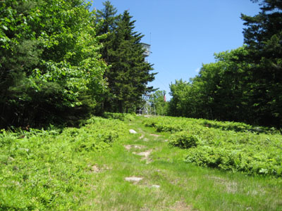
Heading up the last stretch of trail to the fire tower (near the cabins)
Route: Libby Trail
After struggling on the descent of Mt. Hale, it was time to take a step back on the rehab plan, pun intended. Knowing that I had survived an 800 or so vertical hike a week earlier, I decided to try something around 1,000 feet. On a lazy Saturday with roads filled with motorcycles, I decided to go for a local hike.
About a month and a half ago, I saw signs for the Green Mountain fire tower on Libby Road. At the time, the road was plowed in with a snowbank, so I decided to check it out some other day. Today was that day.
The trailhead was probably less than a mile up the road and was marked with a simple fire tower sign. There's no formal parking lot - just a sign saying don't block the gate.
The trail starts off as a flat dirt road, going through a logging operation. After awhile, it adds a little pitch and turns into a fourwheeler trail. There are no signs or blazes.
Shortly after the trail stopped running parallel to the brook, I noticed a fourwheeler trail branching off to the left. I decided to take this. My guess is this is just a shortcut, as a trail merges with this from the right shortly thereafter.
The trail soon enters an evergreen forest, with the Hanson Top Trail branching off to the left (another day). Shortly after this, I saw another fourwheeler trail branching off to the right. Like the previous one, I think this was another shortcut, as a trail merged from the left shortly thereafter.
Before I knew it, I was at the field below the firetower, next to the boarded up cabins. It should be noted that much of this trail and the field is surrounded by wild low bush blueberry vines - I may have to check this out again in early August.
The views from the tower were strong as usual, from Maine to Mount Washington.
On the descent, I tried on a patella strap. It's essentially a velco strap with a gel strip that pushes into the knee just below the patella. While I'm not positive, I think it made a big difference, as I was able to do the entire descent nonestop without any significant pain in my knee.
A nice day for a hike. Git 'r done.
| Hike Ratings |
|
Getting To Trailhead: |
Easy |
| Destination: |
Green Mountain |
|
Length: |
Moderate |
|
Steepness: |
Moderate |
|
Navigation: |
Moderate |
|
Views: |
Excellent |
|
Crowds: |
Minimal |
|
| Hike Stats |
|
Date Hiked: |
Saturday, June 16, 2007 |
| Hike Commenced: |
12:16 PM |
| Parking Elevation: |
725' |
| Destination: |
Green Mountain |
| Ascent Commenced: |
12:16 PM |
| Summit Reached: |
12:54 PM |
| Time Elapsed: |
00:38 |
| Trailhead Elevation: |
725' |
| Summit Elevation: |
1,907' |
| Distance: |
1.5 miles |
| Vertical Gain: |
1,192' |
|
|
| Hike Ended: |
1:43 PM |
| Hike Time Elapsed: |
01:27 |
| Distance: |
3 miles |
| Hike Vertical Gain: |
1,202' |
|
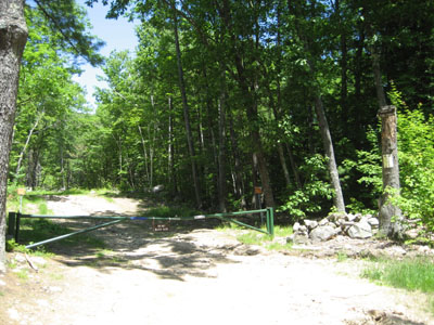
Trailhead on Libby Road
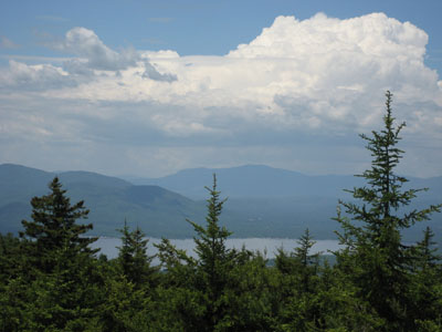
Looking northwest from the Green Mountain summit
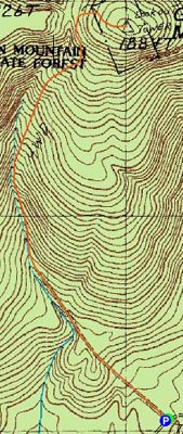

Directions to trailhead: Take Green Mountain Road from Route 25. Bear left onto Champion Road. Libby Road will be shortly thereafter on the left (dirt road, small firetower sign). The road is a bit rough (Class IV). Trailhead is at the top of the hill on the left.
Back to Green Mountain Profile
|


