Home
States
Colorado
Connecticut
Maine
Massachusetts
New Hampshire
New York
Rhode Island
Utah
Vermont
View All
Lists
NE 4,000 Footers
NE 100 Highest
NH 4,000 Footers
NH 100 Highest
NH 52 With A View
NH Belknap Range
NH Ossipee 10
Links
Trail Conditions
Trip Log
Sunrises
Sunsets
About
|
Kearsarge North Mountain
Bartlett, NH, Chatham, NH
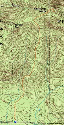
Trailheads, measurements, times, distances, and maps are all approximate and relative to the hike(s) as shown below.
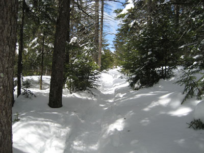
Heading up the Kearsarge North Trail
Route: Kearsarge North Trail
Originally, my intent was to ski Wildcat in the morning and hike Kearsarge North in the afternoon. I then made the mistake of laying down on my couch for a moment. Nonetheless, I was able to get my act together in time for a noon start for hiking.
Upon arriving at the trailhead, the sky was very cloudy and the parking lot was full. This is where a 4 wheel drive pick up comes in handy - you can park in a snowbank and not worry too much about it.
The trail was well packed by previous snowshoers and hikers, so I decided to hike it with just Stablicers. After snowshoeing for what seemed to be forever on Belknap Mountain the night before, I was glad to have a lighter load on my feet.
The beginning of the trail is rather flat - allowing me to do some jogging. Once the brook could be heard, things steepened up a bit - nothing too bad, however.
After just about an hour of hiking, things started to open up - isolated snow fields, lower evergreen growth, etc. In addition, the clouds moved out and it turned sunny. Near the summit, a northwestern view could be seen through the trees as the trail started to get steep in a few short bursts.
The summit fire tower is one of the nicer ones around - with the nearly bare summit, the one story high tower offers excellent views in all directions - and has a nice sized cab open to the public, as well as a wrap around deck.
Seeking my bag of trail mix, I realized my backpack was open...and gloves and winter hat were missing. Opps.
Trying to push myself to exhaustion, I decided to jog much of the way down. Near the very end of the trail, I was fortunate enough to discover my hat and gloves were hung up on trees by some hikers. A good end to a nice hike.
| Hike Ratings |
|
Getting To Trailhead: |
Easy |
| Destination: |
Kearsarge North Mountain |
|
Length: |
Moderate |
|
Steepness: |
Difficult |
|
Navigation: |
Easy |
|
Views: |
Excellent |
|
Crowds: |
Minimal |
|
| Hike Stats |
|
Date Hiked: |
Saturday, April 14, 2007 |
| Hike Commenced: |
11:59 AM |
| Parking Elevation: |
685' |
| Destination: |
Kearsarge North Mountain |
| Ascent Commenced: |
11:59 AM |
| Summit Reached: |
1:41 PM |
| Time Elapsed: |
01:42 |
| Trailhead Elevation: |
685' |
| Summit Elevation: |
3,268' |
| Distance: |
3.1 miles |
| Vertical Gain: |
2,618' |
|
|
| Hike Ended: |
3:00 PM |
| Hike Time Elapsed: |
03:01 |
| Hike Distance: |
6.2 miles |
| Hike Vertical Gain: |
2,653' |
|
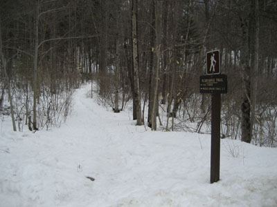
Kearsarge North Trail trailhead on Hurricane Mountain Road
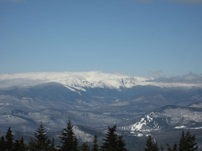
Looking northwest at Mt. Washington from Kearsarge North Mountain

Directions to trailhead: On Route 16 North, take a right after North Conway onto Hurricane Mountain Road. The trailhead and small parking lot will be up the road on the left (before the fork in the road).
Back to Kearsarge North Mountain Profile
|


