Home
States
Colorado
Connecticut
Maine
Massachusetts
New Hampshire
New York
Rhode Island
Utah
Vermont
View All
Lists
NE 4,000 Footers
NE 100 Highest
NH 4,000 Footers
NH 100 Highest
NH 52 With A View
NH Belknap Range
NH Ossipee 10
Links
Trail Conditions
Trip Log
Sunrises
Sunsets
About
|
Kearsarge North Mountain
Bartlett, NH, Chatham, NH
Trailheads, measurements, times, distances, and maps are all approximate and relative to the hike(s) as shown below.
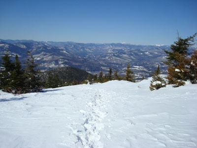
Looking down the Kearsarge North Trail near the summit
Route: Kearsarge North Trail
With an awesome weather forecast and the desire to ski for half a day, I decided to head up to Kearsarge North Mountain for a morning hike.
The trail appeared to be well packed after the recent minor snowstorm, so I decided to bareboot the hike, putting my snowshoes on my backpack.
The packed powder provided plenty of traction, allowing for a much easier ascent as compared to my last two.
The views from the summit tower were tremendous - with the white Franconia Ridge, Foss Mountain, and Saddleback Mountain all standing out. With the minimal winds and strong spring sun, the inside of the fire tower was nice and toasty.
I was surprised to pass very few people on the descent - I would have expected the trail to be a highway with crowds on such a nice day!
| Hike Ratings |
|
Getting To Trailhead: |
Easy |
| Destination: |
Kearsarge North Mountain |
|
Length: |
Moderate |
|
Steepness: |
Difficult |
|
Navigation: |
Easy |
|
Views: |
Excellent |
|
Crowds: |
Minimal |
|
| Hike Stats |
|
Date Hiked: |
Sunday, March 30, 2008 |
| Hike Commenced: |
8:12 AM |
| Parking Elevation: |
685' |
| Destination: |
Kearsarge North Mountain |
| Ascent Commenced: |
8:12 AM |
| Summit Reached: |
9:56 AM |
| Time Elapsed: |
01:44 |
| Trailhead Elevation: |
685' |
| Summit Elevation: |
3,268' |
| Distance: |
3.1 miles |
| Vertical Gain: |
2,618' |
|
|
| Hike Ended: |
11:20 AM |
| Hike Time Elapsed: |
03:08 |
| Hike Distance: |
6.2 miles |
| Hike Vertical Gain: |
2,653' |
|

Kearsarge North Trail trailhead on Hurricane Mountain Road

Looking at Mt. Washington from the Kearsarge North Mountain fire tower


Directions to trailhead: On Route 16 North, take a right after North Conway onto Hurricane Mountain Road. The trailhead and small parking lot will be up the road on the left (before the fork in the road).
Back to Kearsarge North Mountain Profile
|


