Home
States
Colorado
Connecticut
Maine
Massachusetts
New Hampshire
New York
Rhode Island
Utah
Vermont
View All
Lists
NE 4,000 Footers
NE 100 Highest
NH 4,000 Footers
NH 100 Highest
NH 52 With A View
NH Belknap Range
NH Ossipee 10
Links
Trail Conditions
Trip Log
Sunrises
Sunsets
About
|
Kearsarge North Mountain
Bartlett, NH, Chatham, NH
Trailheads, measurements, times, distances, and maps are all approximate and relative to the hike(s) as shown below.
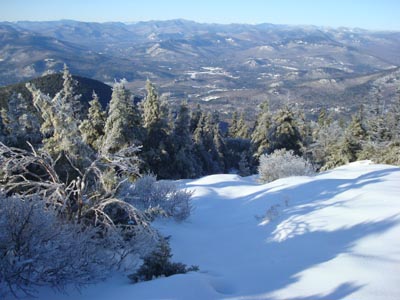
Looking down the Kearsarge North Trail near the summit
Route: Kearsarge North Trail
For my second clean up hike after the great ice storm of December 2008, I decided to head up to Kearsarge North Mountain. With a forecasted clear day, I had a feeling the views would be spectacular.
The parking area was not plowed, resulting in some loud noises as my skid plate based through the firm icebank. Down low on the trail, the damage wasn't bad at all - I even toyed with turning around and heading south where trail maintenance would be needed more. Nevertheless, I continued on.
There was a bit more ice damage up high, but once again, nothing overly bad. Ascending, I picked up was laying loose on the trail, while descending I dealt with the more tricky stuff.
While the trail was mostly barebootable up to the col, the ledges below the summit tower were mostly covered in bulletproof ice (over snow). Once at the summit, I went into the tower, signed the log book, then went out to check out the scenery.
The views from the summit were tremendous - sparkling ice covered mountains to the south and other peaks to the west, north, and northeast as far as the eye could see. The white Presidentials and Franconias were particularly striking.
After taking some view photos, I decided to go back into the tower cab and have some lunch. After getting ready for the descent, I went to open the door, only to find out it was stuck shut! Since there was only a small latch to grab onto, I couldn't get the leverage necessary to break the ice seal that must have formed. I had two options - wait for someone else to show up or find some other way out. Fortunately, the windows open enough to allow a person to climb out - with some careful balancing, I was able to get out the window, then push the door open and retrieve my pack. I then used my multi tool to carefully chip the ice off the door jam, so that hopefully no subsequent visitors would suffer the same fate.
Though I was the first one to arrive at the summit in at least a day or two, the traffic on the trail picked up dramatically by the time I was about 2/3rds of the way down. While it was a nice hike, I was back to the trailhead before lunch - plenty of time left to do more trail cleanup! Time for Mt. Roberts!
| Hike Ratings |
|
Getting To Trailhead: |
Easy |
| Destination: |
Kearsarge North Mountain |
|
Length: |
Moderate |
|
Steepness: |
Difficult |
|
Navigation: |
Easy |
|
Views: |
Excellent |
|
Crowds: |
Minimal |
|
| Hike Stats |
|
Date Hiked: |
Saturday, December 13, 2008 |
| Hike Commenced: |
8:23 AM |
| Parking Elevation: |
685' |
| Destination: |
Kearsarge North Mountain |
| Ascent Commenced: |
8:23 AM |
| Summit Reached: |
9:53 AM |
| Time Elapsed: |
01:30 |
| Trailhead Elevation: |
685' |
| Summit Elevation: |
3,268' |
| Distance: |
3.1 miles |
| Vertical Gain: |
2,618' |
|
|
| Hike Ended: |
11:47 AM |
| Hike Time Elapsed: |
03:24 |
| Hike Distance: |
6.2 miles |
| Hike Vertical Gain: |
2,653' |
|
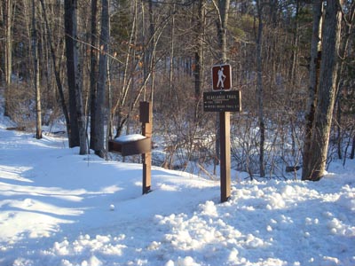
Kearsarge North Trail trailhead on Hurricane Mountain Road
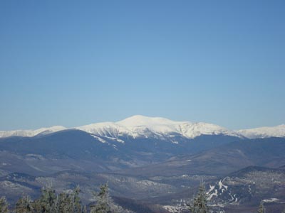
Looking at Mt. Washington from the Kearsarge North Mountain fire tower
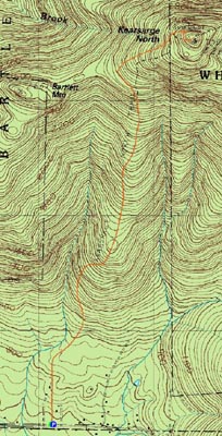

Directions to trailhead: On Route 16 North, take a right after North Conway onto Hurricane Mountain Road. The trailhead and small parking lot will be up the road on the left (before the fork in the road).
Back to Kearsarge North Mountain Profile
|


