Home
States
Colorado
Connecticut
Maine
Massachusetts
New Hampshire
New York
Rhode Island
Utah
Vermont
View All
Lists
NE 4,000 Footers
NE 100 Highest
NH 4,000 Footers
NH 100 Highest
NH 52 With A View
NH Belknap Range
NH Ossipee 10
Links
Trail Conditions
Trip Log
Sunrises
Sunsets
About
|
Little Ball Mountain, Big Ball Mountain
Tuftonboro, NH
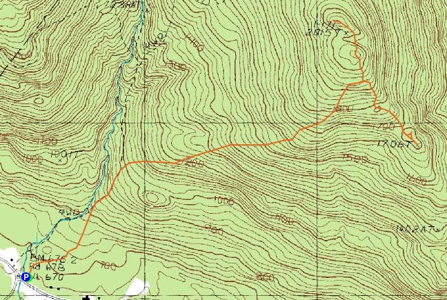
Trailheads, measurements, times, distances, and maps are all approximate and relative to the hike(s) as shown below.
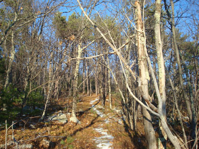
Looking up the Tate Mountain Trail
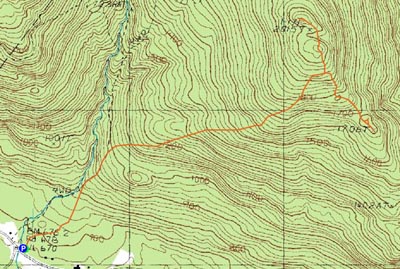
Route: Mt. Shaw Trail, Tate Mountain Trail, Banana Trail, herd path, (Little Ball Mountain), herd path, Banana Trail, (Big Ball Mountain), Banana Trail, Tate Mountain Trail, Mt. Shaw Trail
After getting a great tour of the Ossipees and surrounding area by air, I decided to head down to the Mt. Shaw Trail trailhead and head up to Big Ball Mountain for a sunset hike.
Though there were patches of snow throughout the ascent, nothing was more than an inch or two deep. Having previously ascended the Tate Mountain Trail on a cloudy day, I was surprised to see how scenic the upper portion really was on a sunny day. Reaching the Banana Trail ahead of schedule, I decided to head down to Little Ball Mountain and check it out.
With the patches of snow filling in the dips of the terrain, and with some of the old, random cairns, I found it a bit confusing descending the Banana Trail for this stretch (even though I've been on this trail a few times before). Nonetheless, Little Ball Mountain was visible, and soon I was making my way down a herd path toward it. On a steep drop, I slipped on some leaves and landed hard on my leg - fortunately I was able to continue on.
There were three unique viewpoints near the summit of Little Ball Mountain - a lake view from what seems to me to be the highpoint, a southern viewpoint from what appears to be marked with an elevation on the topographic map, and an eastern viewpoint looking at Dan Hole near the highpoint.
After checking out the views, I headed back up the spur trail and up the Banana Trail. The section of trail between the twin peaks of Big Ball Mountain was a bit tricky, as the short ledge scramble and bypass were both iced over.
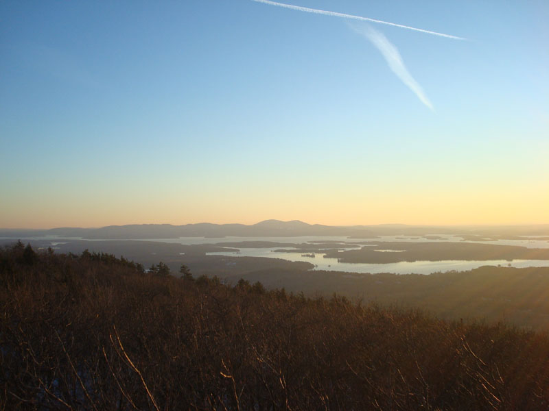
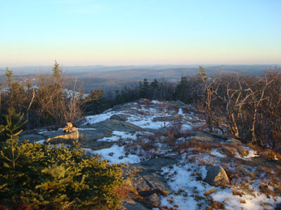
The views from the summit of Big Ball Mountain were great as usual. Though it was fairly warm when I started the hike, I quickly chilled while sitting in the wind waiting for the sunset. Despite the lack of clouds in the sky, the colors were tremendous.
After watching the horizon for about ten minutes after the actual sunset, I started my descent. Thanks in part to the continued colors coming from the horizon, as well as the patches of snow, I was able to get a decent amount of hiking in without needing to rely upon my headlamp. The Banana and Tate Mountain Trails were also quite scenic for the descent, as there were multiple nice views of the colorful horizon. For that reason, and for the summit views, I think Big Ball Mountain is one of the best Lakes Region sunset hikes.
| Hike Ratings |
|
Getting To Trailhead: |
Easy |
| Destination: |
Little Ball Mountain |
|
Length: |
Moderate |
|
Steepness: |
Difficult |
|
Navigation: |
Moderate |
|
Views: |
Excellent |
|
Crowds: |
Minimal |
| Destination: |
Big Ball Mountain |
|
Length: |
Moderate |
|
Steepness: |
Difficult |
|
Navigation: |
Moderate |
|
Views: |
Excellent |
|
Crowds: |
Minimal |
|
| Hike Stats |
|
Date Hiked: |
Wednesday, December 3, 2008 |
| Hike Commenced: |
2:35 PM |
| Parking Elevation: |
670' |
| Destination: |
Little Ball Mountain |
| Ascent Commenced: |
2:35 PM |
| Summit Reached: |
3:28 PM |
| Time Elapsed: |
00:53 |
| Trailhead Elevation: |
675' |
| Summit Elevation: |
1,710' |
| Vertical Gain: |
1,310' |
| Destination: |
Big Ball Mountain |
| Ascent Commenced: |
3:33 PM |
| Summit Reached: |
3:50 PM |
| Time Elapsed: |
00:17 |
| Trailhead Elevation: |
1,710' |
| Summit Elevation: |
2,060' |
| Vertical Gain: |
420' |
|
|
| Hike Ended: |
5:12 PM |
| Hike Time Elapsed: |
02:37 |
| Hike Vertical Gain: |
1,810' |
|
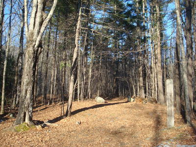
The Mt. Shaw Trail trailhead
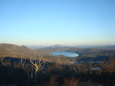
Looking at Dan Hole Pond from near the summit of Little Ball Mountain
Looking down the Banana Trail near Big Ball Mountain
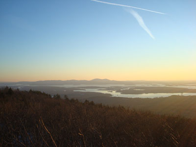
Looking at the Belknaps from the summit of Big Ball Mountain
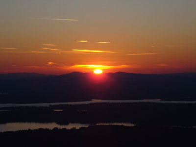
The sunset over Ragged Mountain as seen from Big Ball Mountain

Directions to trailhead: Take 171 southeast from Route 25, past Castle in the Clouds. Shortly after crossing the Tuftonboro town line, there is a bridge/brook crossing. Immediately after this, there is an informal parking lot on the left (maybe 4 cars). The unmarked trail starts at the back of this lot.
Back to Little Ball Mountain Profile
Back to Big Ball Mountain Profile
|