Home
States
Colorado
Connecticut
Maine
Massachusetts
New Hampshire
New York
Rhode Island
Utah
Vermont
View All
Lists
NE 4,000 Footers
NE 100 Highest
NH 4,000 Footers
NH 100 Highest
NH 52 With A View
NH Belknap Range
NH Ossipee 10
Links
Trail Conditions
Trip Log
Sunrises
Sunsets
About
|
Mittersill Peak, Cannon Mountain
Franconia, NH
Trailheads, measurements, times, distances, and maps are all approximate and relative to the hike(s) as shown below.

Looking up the Taft Trail on the way up to the peak of Mittersill
Route: Taft Cut Off, Taft Trail, (Mittersill Peak), Taft Trail, spur trail, (Cannon Mountain), spur trail, Taft Trail, (Mittersill Peak), Taft Trail, Taft Cut Off
Indexing my vehicle's thermometer to the bank signs, it appeared to be about 0 degrees when I arrived at the base of the old Mittersill double chairlift. Since this was a late afternoon hike, the temperature would only be plummeting.
My original intent was to sort of follow the double chairlift line like I had the previous winter. Seeing that there was very little skier traffic, however, I decided to head up the Taft Cut Off to the Taft Trail, to hopefully find something a bit packed down. After passing near the top of the Tuckerbrook quad chairlift, there was a bit more evidence of skier traffic, and thus, not much more trail breaking to do.
Rounding a corner, I was surprised to see lots of small spruce growth in the trail - I've generally found the old Mittersill trails decently maintained. Other than occasionally snagging my snowshoe, it wasn't too bad nonetheless.
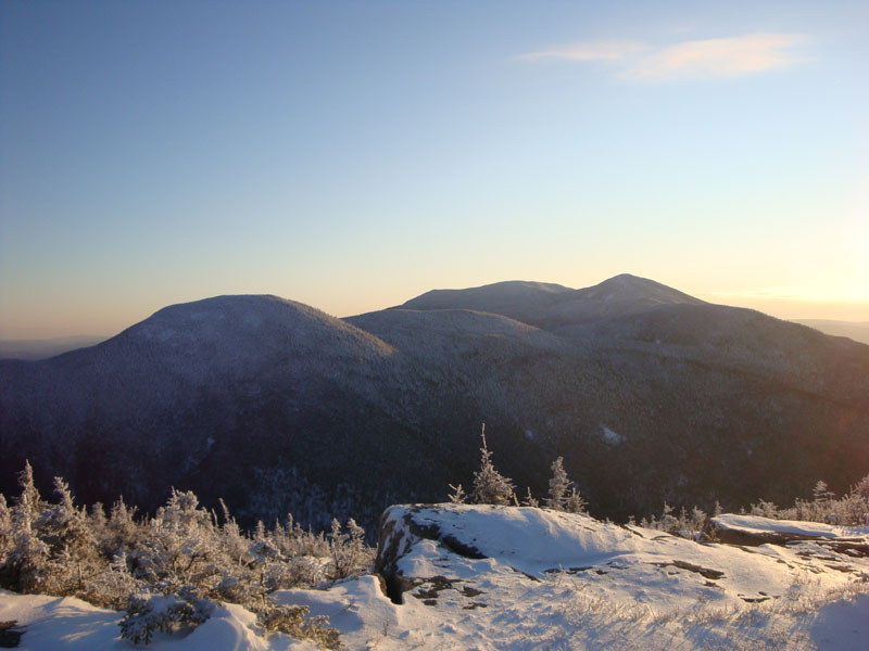
Soon, I arrived at the top of the old double chairlift. Up to this point, I had been over the shoulder of Mittersill and had thus not had much sunlight. Above here, however, things began to brighten up. As I reached the top of the peak, I was greeted with tremendous views, ranging from points in Vermont to the Franconia Ridge to Northeast Cannonball to the Kinsmans.
The next segment of trail was surprisingly quiet - even though I was snowshoeing right up an active ski trail. I only saw two skiers the entire time.
The spur trail from the top of the Cannonball Quad chairlift was drifted and not broken out. Nonetheless, it wasn't overly heard to ascend. Arriving at the base of the observation tower, I quickly swapped base layers and geared up for the rest of the hike. Other than the occasional mild gust, the winds were not bad at all.
The views from the observation tower were the best I've ever had during my four hikes to Cannon thus far. Had the weather been warmer, I would have considered waiting for the sunset. My toes were starting to get cold, however, so I headed back down the stairs and was soon on my way down the hill.
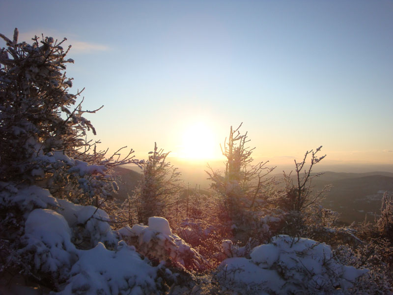
The only sizable winds I encountered during the entire hike were directly at my face as I decided the ski trail. Once I dipped into the col, things became a bit more mild. Back on the top of the Mittersill peak, a yellow glow was starting to develop behind the Kinsmans. As I descended, the horizon started to evolve into sunset colors. Unfortunately, there wasn't a good perspective to get any sunset shots (other than waiting on the top of the fairly exposed Mittersill peak, which I didn't want to do in this weather).
Reaching the bottom, there was a beautiful glow behind the base of the chairlift. According to my bank-indexed vehicle thermometer, it was 7 degrees below zero at the base at this point. Just a little bit chilly!
| Hike Ratings |
|
Getting To Trailhead: |
Easy |
| Destination: |
Mittersill Peak |
|
Length: |
Moderate |
|
Steepness: |
Difficult |
|
Navigation: |
Moderate |
|
Views: |
Excellent |
|
Crowds: |
Minimal |
| Destination: |
Cannon Mountain |
|
Length: |
Moderate |
|
Steepness: |
Difficult |
|
Navigation: |
Easy |
|
Views: |
Excellent |
|
Crowds: |
Minimal |
|
| Hike Stats |
|
Date Hiked: |
Thursday, January 15, 2009 |
| Hike Commenced: |
2:10 PM |
| Parking Elevation: |
1,860' |
| Destination: |
Mittersill Peak |
| Ascent Commenced: |
2:10 PM |
| Summit Reached: |
3:06 PM |
| Time Elapsed: |
00:56 |
| Trailhead Elevation: |
1,870' |
| Summit Elevation: |
3,617' |
| Vertical Gain: |
1,747' |
| Destination: |
Cannon Mountain |
| Ascent Commenced: |
3:07 PM |
| Summit Reached: |
3:29 PM |
| Time Elapsed: |
00:22 |
| Trailhead Elevation: |
3,617' |
| Summit Elevation: |
4,100' |
| Vertical Gain: |
605' |
|
|
| Hike Ended: |
5:00 PM |
| Hike Time Elapsed: |
02:50 |
| Hike Vertical Gain: |
2,449' |
|

Looking up the old Mittersill ski area

Looking at Northeast Cannonball and the Kinsmans from near the summit of Mittersill peak

The spur trail to the summit of Cannon Mountain

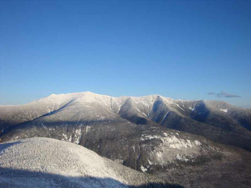
Looking at the Franconia Ridge from the Cannon Mountain observation tower

Sunset colors as seen from near the top of Mittersill


Directions to trailhead: Take I-93 North to the Cannon Mountain Peabody Slopes exit. Continue past the Cannon entrance, taking a left at the Mittersill sign. There are multiple parking areas on the left a fraction of a mile down this road. Looking uphill adjacent to the old double chairlift, the Taft Cut Off Trail is the furthest to the left.
Back to Mittersill Peak Profile
Back to Cannon Mountain Profile
|