Home
States
Colorado
Connecticut
Maine
Massachusetts
New Hampshire
New York
Rhode Island
Utah
Vermont
View All
Lists
NE 4,000 Footers
NE 100 Highest
NH 4,000 Footers
NH 100 Highest
NH 52 With A View
NH Belknap Range
NH Ossipee 10
Links
Trail Conditions
Trip Log
Sunrises
Sunsets
About
|
Mt. Chocorua
Albany, NH
Trailheads, measurements, times, distances, and maps are all approximate and relative to the hike(s) as shown below.

Looking up the Bee Line Trail
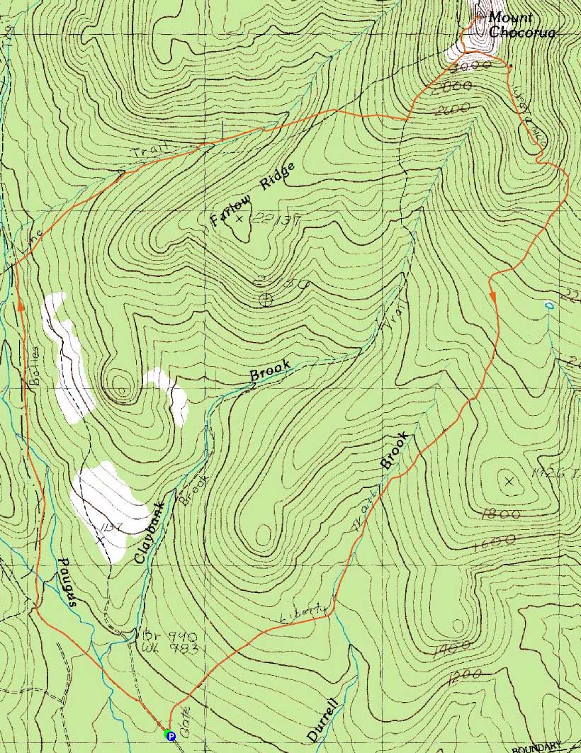
Route: Bolles Trail, Bee Line Trail, Brook Trail, Liberty Trail, (Mt. Chocorua), Liberty Trail
Fed up with monorail, I decided to stay south and try a new (to me) approach to Mt. Chocorua. Arriving at a nearly empty Paugus Mill parking lot, I quickly set foot up the Bolles Trail. Shortly after crossing the brook (easily done with the large stepping stones), my progress slowed, as I felt compelled to work on cleaning up a hoard of blowdowns.
Finally reaching the Bee Line Trail, I continued to progress slowly, as there were plenty of branches and trees down. I noted at least two reroutes of the trail - a very recent one prior to the first water crossing, and then a much older one up high (this reroute pushes the trail to the Brook Trail).
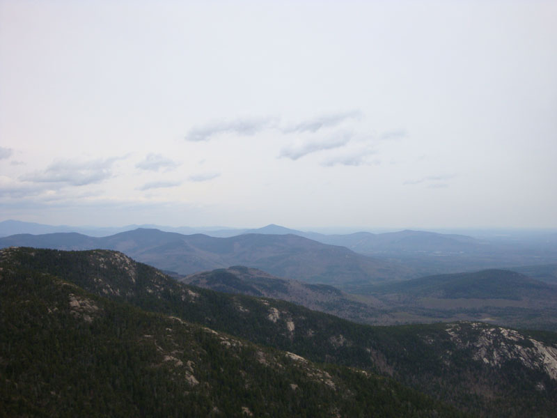
After fairly moderate grades on the Bee Line Trail (other than a short stretch near the top), things picked up on the Brook Trail with the scramble ledges. While the views were decent, the grey skies took away from the scenery.
After passing a grand total of three tiny patches of snow, I soon reached a fairly empty summit. After hanging out and taking in the views for a bit, I decided to retreat as the light but chilly wind was catching up to me.
Though not as bad, the Liberty Trail also required a lot of blowdown work, once again slowing my hike. Though there was a bit of snow along the traverse below the hut, the trail was mostly snow free. Back at the Paugus Mill parking lot, mosquitoes were starting to make an appearance.
Despite the grey skies, it was nice to get in a Chocorua loop.
| Hike Ratings |
|
Getting To Trailhead: |
Easy |
| Destination: |
Mt. Chocorua |
|
Length: |
Moderate |
|
Steepness: |
Difficult |
|
Navigation: |
Moderate |
|
Views: |
Excellent |
|
Crowds: |
Minimal |
|
| Hike Stats |
|
Date Hiked: |
Sunday, May 3, 2009 |
| Hike Commenced: |
8:16 AM |
| Parking Elevation: |
900' |
| Destination: |
Mt. Chocorua |
| Ascent Commenced: |
8:16 AM |
| Summit Reached: |
10:53 AM |
| Time Elapsed: |
02:37 |
| Trailhead Elevation: |
900' |
| Summit Elevation: |
3,474' |
| Distance: |
4.3 miles |
| Vertical Gain: |
2,704' |
|
|
| Hike Ended: |
1:53 PM |
| Hike Time Elapsed: |
05:37 |
| Hike Distance: |
8.2 miles |
| Hike Vertical Gain: |
2,844' |
|

The Bolles Trail trailhead at Paugus Mill

A trillium on the Bolles Trail

Looking toward Kearsarge North Mountain from the summit of Mt. Chocorua

A pair of frogs hanging out on the Liberty Trail


Directions to trailhead: From Route 25, take Route 113 East to Tamworth. At the four way intersection next to the village, go straight onto 113A. Continue a few minutes, taking a right onto Fowler's Mill Road. A few minutes later, take a left onto Paugus Road. The WMNF fee parking area is at the end of this road.
Back to Mt. Chocorua Profile
|