Home
States
Colorado
Connecticut
Maine
Massachusetts
New Hampshire
New York
Rhode Island
Utah
Vermont
View All
Lists
NE 4,000 Footers
NE 100 Highest
NH 4,000 Footers
NH 100 Highest
NH 52 With A View
NH Belknap Range
NH Ossipee 10
Links
Trail Conditions
Trip Log
Sunrises
Sunsets
About
|
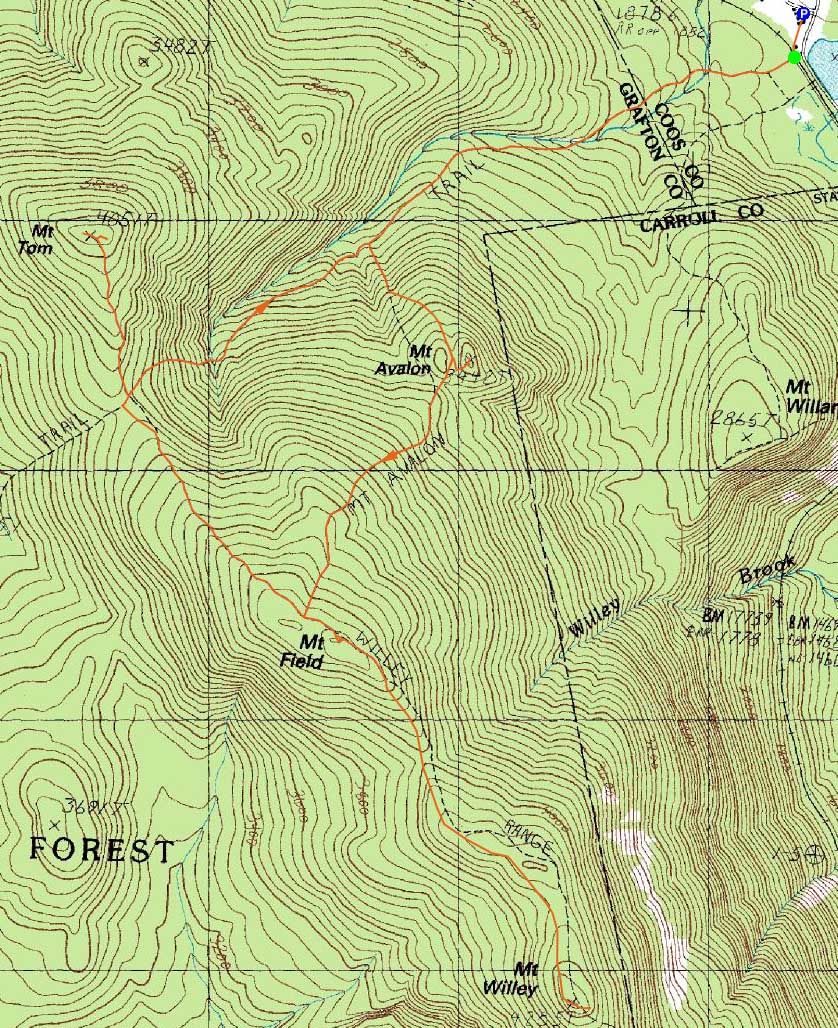
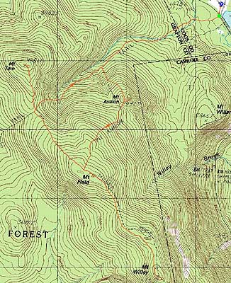
Mt. Avalon, Mt. Field, Mt. Willey, Mt. Tom
Carroll, NH, Bethlehem, NH
Trailheads, measurements, times, distances, and maps are all approximate and relative to the hike(s) as shown below.
The Avalon Trail
Route: Avalon Trail, (spur trail to summit), (Mt. Avalon), (spur trail from summit), Avalon Trail, Willey Range Trail, (Mt. Field), Willey Range Trail, (Mt. Willey), Willey Range Trail, (Mt. Field), Willey Range Trail, A-Z Trail, Mt. Tom Spur Trail, (Mt. Tom), Mt. Tom Spur Trail, A-Z Trail, Avalon Trail
On a cold, windy day, the Willey Range seemed like a good choice. With the temperature around zero for the start, it took a little while to get warmed up. Reaching the steeps on the Avalon Trail, I had a decent pace going, doing light (2-3") trailbreaking. Reaching the Avalon col, the trail was drifted over. In addition, the summit spur sign was not visible - the tree had fallen down. Fortunately I'm all too familiar with that area, so I was able to get up to the summit for some nice Presidential views without any confusion.
The next stop was Mt. Field. Things were a bit drifted here as well. In addition, the upper portions of the trail had a few blowdowns to get around. Nonetheless, after putting on my jacket at the trail junction, I soon arrived at Mt. Field, where the snow-depth-enhanced views were superb.
The trailbreaking continued as I worked my way to Mt. Willey. In addition to 1-3' drifts obscuring the footbed, a decent number of blowdowns, as well as a general lack of blazes, made navigation tricky. While I know most of the route decently, I did find myself scratching my head briefly as I neared the final short ascent (prior to the traverse to the summit). On the return trip, I realized this confusion was due to multiple blowdowns.
The views from Mt. Willey were quite strong as well - Presidentials in the clear, and the Bonds-Twins range quite striking in the other direction. While I was tempted to book it back to Field and then to Tom, as to give myself enough time to perhaps do a short hike in the afternoon, I decided to instead take my time and remove a bunch of blowdowns. While I was able to cut up around twenty or so on the Willey Range Trail, there were still quite a few remaining.
Finally reaching the (at this point) heavily travelled Mt. Tom Spur, I was surprised to see that no one had been to the actual summit (left at the height of land on the spur). From there, the views were once again strong, with Mt. Mansfield easily seen. Back at the height of land, I lightly bushwhacked over to the bench and Mt. Washington view, where I had a snack and too in the scenery.
The descent went smoothly, thanks to a fairly smooth footbed that made for great snowshoeing. Despite the temperatures and blowdowns, it was a nice day to be on the Willey Range.
| Hike Ratings |
|
Getting To Trailhead: |
Easy |
| Destination: |
Mt. Avalon |
|
Length: |
Moderate |
|
Steepness: |
Difficult |
|
Navigation: |
Difficult |
|
Views: |
Excellent |
|
Crowds: |
Moderate |
| Destination: |
Mt. Field |
|
Length: |
Moderate |
|
Steepness: |
Difficult |
|
Navigation: |
Moderate |
|
Views: |
Excellent |
|
Crowds: |
Minimal |
| Destination: |
Mt. Willey |
|
Length: |
Moderate |
|
Steepness: |
Difficult |
|
Navigation: |
Difficult |
|
Views: |
Excellent |
|
Crowds: |
Minimal |
| Destination: |
Mt. Field |
|
Length: |
Moderate |
|
Steepness: |
Difficult |
|
Navigation: |
Easy |
|
Views: |
Excellent |
|
Crowds: |
Heavy |
| Destination: |
Mt. Tom |
|
Length: |
Moderate |
|
Steepness: |
Difficult |
|
Navigation: |
Easy |
|
Views: |
Excellent |
|
Crowds: |
Heavy |
|
| Hike Stats |
|
Date Hiked: |
Saturday, January 30, 2010 |
| Hike Commenced: |
8:23 AM |
| Parking Elevation: |
1,900' |
| Destination: |
Mt. Avalon |
| Ascent Commenced: |
8:23 AM |
| Summit Reached: |
9:31 AM |
| Time Elapsed: |
01:08 |
| Trailhead Elevation: |
1,900' |
| Summit Elevation: |
3,442' |
| Distance: |
1.8 miles |
| Vertical Gain: |
1,567' |
| Destination: |
Mt. Field |
| Ascent Commenced: |
9:31 AM |
| Summit Reached: |
10:19 AM |
| Time Elapsed: |
00:48 |
| Trailhead Elevation: |
3,442' |
| Summit Elevation: |
4,340' |
| Distance: |
.9 mile |
| Vertical Gain: |
995' |
| Destination: |
Mt. Willey |
| Ascent Commenced: |
10:20 AM |
| Summit Reached: |
11:14 AM |
| Time Elapsed: |
00:54 |
| Trailhead Elevation: |
4,340' |
| Summit Elevation: |
4,285' |
| Distance: |
1.4 miles |
| Vertical Gain: |
465' |
| Destination: |
Mt. Field |
| Ascent Commenced: |
11:21 AM |
| Summit Reached: |
12:54 PM |
| Time Elapsed: |
01:33 |
| Trailhead Elevation: |
4,285' |
| Summit Elevation: |
4,340' |
| Distance: |
1.4 miles |
| Vertical Gain: |
520' |
| Destination: |
Mt. Tom |
| Ascent Commenced: |
12:54 PM |
| Summit Reached: |
1:52 PM |
| Time Elapsed: |
00:58 |
| Trailhead Elevation: |
4,340' |
| Summit Elevation: |
4,051' |
| Distance: |
1.5 miles |
| Vertical Gain: |
411' |
|
|
| Hike Ended: |
3:26 PM |
| Hike Time Elapsed: |
07:03 |
| Hike Distance: |
9.9 miles |
| Hike Vertical Gain: |
4,128' |
|
The Avalon Trail trailhead next to the train station
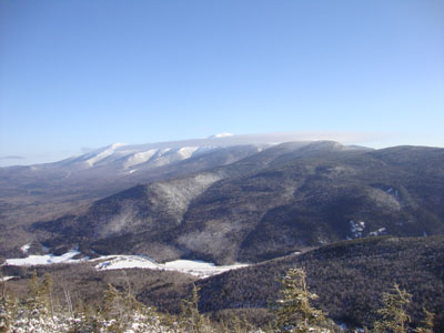
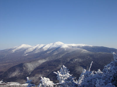
Mt. Washington as seen from Mt. Avalon
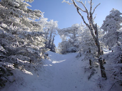
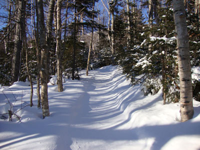
The Willey Range Trail to Mt. Field
Mt. Washington as seen from the Mt. Field view point

The Willey Range Trail between Mt. Field and Mt. Willey

Looking at the Bonds and Twins from near the summit of Mt. Willey

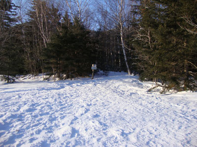
The top of the Mt. Tom Spur Trail, just around the corner from the high point

Mt. Washington as seen from near the Mt. Tom summit

Directions to trailhead: Take Route 302 west from Bartlett, NH. In the winter, there is plowed parking available at the Highland Center. Trailhead is across the tracks, next to the Crawford Depot.
Back to Mt. Avalon Profile
Back to Mt. Field Profile
Back to Mt. Willey Profile
Back to Mt. Tom Profile
|