Home
States
Colorado
Connecticut
Maine
Massachusetts
New Hampshire
New York
Rhode Island
Utah
Vermont
View All
Lists
NE 4,000 Footers
NE 100 Highest
NH 4,000 Footers
NH 100 Highest
NH 52 With A View
NH Belknap Range
NH Ossipee 10
Links
Trail Conditions
Trip Log
Sunrises
Sunsets
About
|
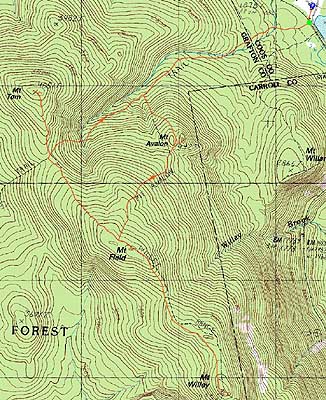
Mt. Avalon, Mt. Field, Mt. Willey, Mt. Tom
Carroll, NH, Bethlehem, NH
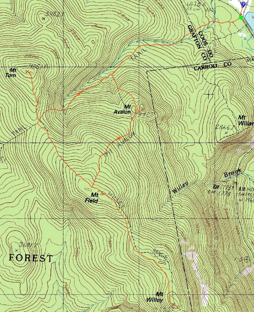
Trailheads, measurements, times, distances, and maps are all approximate and relative to the hike(s) as shown below.
The Avalon Trail
Route: Avalon Trail, (spur trail to summit), (Mt. Avalon), (spur trail from summit), Avalon Trail, Willey Range Trail, (Mt. Field), Willey Range Trail, bushwhack, Willey Range Trail, (Mt. Willey), Willey Range Trail, bushwhack, Willey Range Trail, (Mt. Field), Willey Range Trail, A-Z Trail, Mt. Tom Spur Trail, (Mt. Tom), Mt. Tom Spur Trail, A-Z Trail, Avalon Trail
While the forecast was initially for poor weather, things seemed much nicer as we started up the Avalon Trail. While first water crossing was snowbridged, the second one was open.
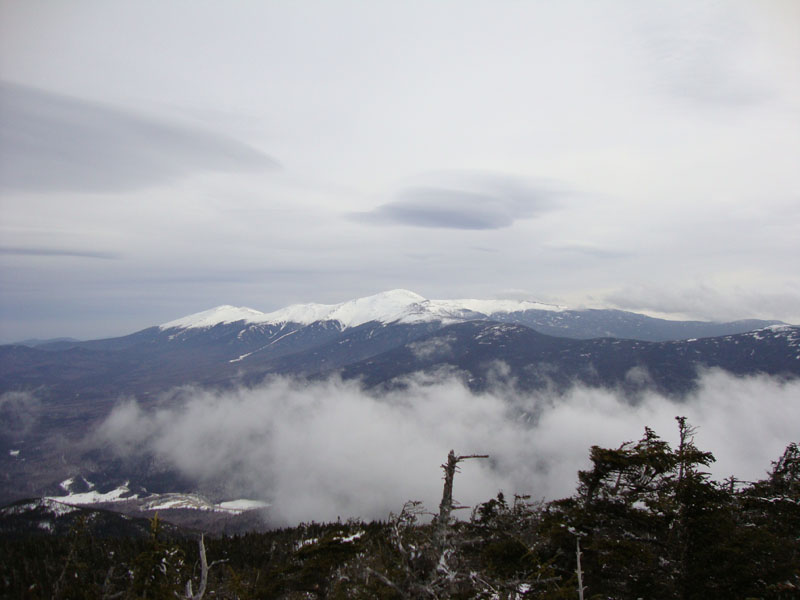
Reaching the summit of Mt. Avalon, there were nice views of the Presidentials - much nicer than the rain and clouds forecast a day or two earlier.
From Avalon to Field, there had been no recent foot traffic. As a result, along with lots of snow and blowdowns, we meandered off the trail a few minutes below the Willey Range Trail, though probably by no more than a few hundred feet. The summit area of Field was quite interesting - as the small spruce trees were mostly hidden under feet of snow. The views were quite strong.
Heading over to Willey, we found the trail to once again be vague. Nonetheless, we were able to follow it for the first half of the segment. We soon hit some postholed areas which were even more vexing due to spruce trees leaning into the trail. As a result, we opted to bushwhack a bit below the tree in open woods, rejoining the trail for the final walk to the summit of Mt. Willey. While I could see into the Pemi when I reached the highpoint, clouds moved in immediately, resulting in no further views.
Back on Field (with good views again, thanks to the clouds moving back out), we pushed on to the A-Z Trail - it appeared that we were the first ones to stay on the trail in quite a few weeks. Climbing up to Mt. Tom, we had excellent views of the Presidentials and Pemi peaks.
For the descent, we opted to go off trail in a few places, as to avoid monorail and postholes.
| Hike Ratings |
|
Getting To Trailhead: |
Easy |
| Destination: |
Mt. Avalon |
|
Length: |
Moderate |
|
Steepness: |
Difficult |
|
Navigation: |
Moderate |
|
Views: |
Excellent |
|
Crowds: |
Minimal |
| Destination: |
Mt. Field |
|
Length: |
Moderate |
|
Steepness: |
Difficult |
|
Navigation: |
Difficult |
|
Views: |
Excellent |
|
Crowds: |
Minimal |
| Destination: |
Mt. Willey |
|
Length: |
Moderate |
|
Steepness: |
Difficult |
|
Navigation: |
Difficult |
|
Views: |
Moderate (due to weather) |
|
Crowds: |
Minimal |
| Destination: |
Mt. Field |
|
Length: |
Moderate |
|
Steepness: |
Difficult |
|
Navigation: |
Moderate |
|
Views: |
Excellent |
|
Crowds: |
Minimal |
| Destination: |
Mt. Tom |
|
Length: |
Moderate |
|
Steepness: |
Difficult |
|
Navigation: |
Difficult |
|
Views: |
Excellent |
|
Crowds: |
Minimal |
|
| Hike Stats |
|
Date Hiked: |
Sunday, March 28, 2010 |
| Hike Commenced: |
7:56 AM |
| Parking Elevation: |
1,900' |
| Destination: |
Mt. Avalon |
| Ascent Commenced: |
7:59 AM |
| Summit Reached: |
8:58 AM |
| Time Elapsed: |
00:59 |
| Trailhead Elevation: |
1,900' |
| Summit Elevation: |
3,442' |
| Distance: |
1.8 miles |
| Vertical Gain: |
1,567' |
| Destination: |
Mt. Field |
| Ascent Commenced: |
8:59 AM |
| Summit Reached: |
9:45 AM |
| Time Elapsed: |
00:46 |
| Trailhead Elevation: |
3,442' |
| Summit Elevation: |
4,340' |
| Vertical Gain: |
995' |
| Destination: |
Mt. Willey |
| Ascent Commenced: |
9:48 AM |
| Summit Reached: |
10:45 AM |
| Time Elapsed: |
00:57 |
| Trailhead Elevation: |
4,340' |
| Summit Elevation: |
4,285' |
| Vertical Gain: |
465' |
| Destination: |
Mt. Field |
| Ascent Commenced: |
10:50 AM |
| Summit Reached: |
11:38 AM |
| Time Elapsed: |
00:48 |
| Trailhead Elevation: |
4,285' |
| Summit Elevation: |
4,340' |
| Vertical Gain: |
520' |
| Destination: |
Mt. Tom |
| Ascent Commenced: |
11:39 AM |
| Summit Reached: |
12:28 PM |
| Time Elapsed: |
00:49 |
| Trailhead Elevation: |
4,340' |
| Summit Elevation: |
4,051' |
| Vertical Gain: |
411' |
|
|
| Hike Ended: |
2:02 PM |
| Hike Time Elapsed: |
06:06 |
| Hike Vertical Gain: |
4,128' |
|
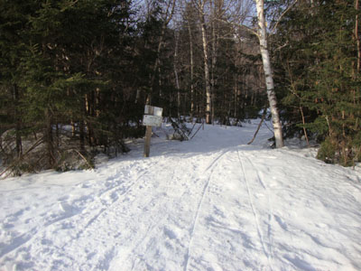
The Avalon Trail trailhead next to the train station
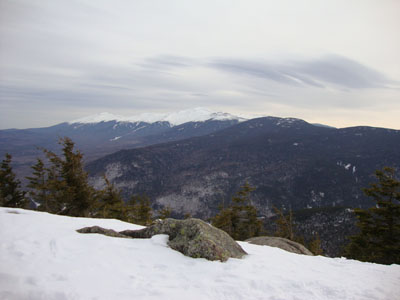
The Presidentials as seen from Mt. Avalon
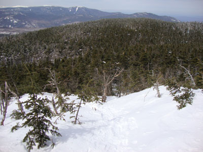
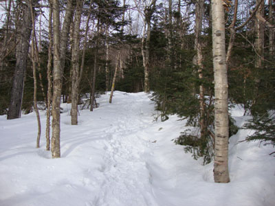
The Willey Range Trail to Mt. Field

The Presidentials as seen from Mt. Field

The Willey Range Trail between Mt. Field and Mt. Willey

Brief Pemi views as seen from Mt. Willey

The Willey Range Trail on the way to Mt. Tom

The Bonds and Twins as seen from Mt. Tom

Directions to trailhead: Take Route 302 west from Bartlett, NH. In the winter, there is plowed parking available at the Highland Center. Trailhead is across the tracks, next to the Crawford Depot.
Back to Mt. Avalon Profile
Back to Mt. Field Profile
Back to Mt. Willey Profile
Back to Mt. Tom Profile
|