Home
States
Colorado
Connecticut
Maine
Massachusetts
New Hampshire
New York
Rhode Island
Utah
Vermont
View All
Lists
NE 4,000 Footers
NE 100 Highest
NH 4,000 Footers
NH 100 Highest
NH 52 With A View
NH Belknap Range
NH Ossipee 10
Links
Trail Conditions
Trip Log
Sunrises
Sunsets
About
|
Mt. Hancock (North Peak), Mt. Hancock (South Peak)
Lincoln, NH, Livermore, NH
Trailheads, measurements, times, distances, and maps are all approximate and relative to the hike(s) as shown below.
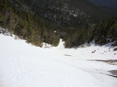
Looking down the Arrow Slide on the way to North Hancock
Route: Hancock Notch Trail, Cedar Brook Trail, bushwhack, Hancock Loop Trail, bushwhack, Arrow Slide, bushwhack, (Mt. Hancock North Peak), Hancock Loop Trail, (Mt. Hancock South Peak), Hancock Loop Trail, bushwhack, Cedar Brook Trail, Hancock Notch Trail
Instead of doing a vanilla Hancock loop, we opted to mix things up a bit. With water crossings running a bit high with recent rain and subsequent warm temperatures, we bushwhacked along the east side of Cedar Brook, eventually reaching the Hancock Loop Trail above the crossings. Once at the foot of the north branch of the loop, we pushed along the shore of a temporary pond (due to runoff) and hopped into the drainage of the Arrow Slide.
Baking in the sun, we climbed up along the eastern side of the Arrow Slide, using our axes on the second half to minimize slipping. While we were able to make it all the way up to the right finger of the slide in snowshoes, we probably would have been better suited in crampons for the upper half. Even with the soft snow, it was certainly a no fall zone. In addition, we had to stay alert to the top of the slide, as, in one instance, we witnessed a large rock fall out of the left finger and bounce down the slide.
After an extended break near the top of the right finger, we continued to the top (alongside the snowpack, as the top portion of the snowpack appeared to be very unstable and thus likely to slide) and then bushwhacked over to the trail, soon reaching the summit of North Hancock. With the deep snowpack, we had tremendous views, ranging from Carrigain to Owl's Head.
After passing a territorial grouse not too far from the summit, we continued to South Hancock, where once again the snowpack allowed for excellent views near the summit. After another snack break, we headed down the steep south branch of the loop, then back along our Cedar Brook bushwhack, then out the Hancock Notch Trail - the entire hike on snowshoes.
| Hike Ratings |
|
Getting To Trailhead: |
Easy |
| Destination: |
Mt. Hancock (North Peak) |
|
Length: |
Moderate |
|
Steepness: |
Very Difficult |
|
Navigation: |
Difficult |
|
Views: |
Excellent |
|
Crowds: |
Minimal |
| Destination: |
Mt. Hancock (South Peak) |
|
Length: |
Moderate |
|
Steepness: |
Difficult |
|
Navigation: |
Moderate |
|
Views: |
Excellent |
|
Crowds: |
Minimal |
|
| Hike Stats |
|
Date Hiked: |
Thursday, April 1, 2010 |
| Hike Commenced: |
11:19 AM |
| Parking Elevation: |
2,140' |
| Destination: |
Mt. Hancock (North Peak) |
| Ascent Commenced: |
11:19 AM |
| Summit Reached: |
2:39 PM |
| Time Elapsed: |
03:20 |
| Trailhead Elevation: |
2,140' |
| Summit Elevation: |
4,420' |
| Vertical Gain: |
2,500' |
| Destination: |
Mt. Hancock (South Peak) |
| Ascent Commenced: |
2:46 PM |
| Summit Reached: |
3:41 PM |
| Time Elapsed: |
00:55 |
| Trailhead Elevation: |
4,420' |
| Summit Elevation: |
4,319' |
| Distance: |
1.4 miles |
| Vertical Gain: |
534' |
|
|
| Hike Ended: |
5:55 PM |
| Hike Time Elapsed: |
06:36 |
| Hike Vertical Gain: |
3,184' |
|

The Hancock Notch Trail trailhead

Looking up the Arrow Slide near the top

The Tripyramids, Sandwich Dome, and the Osceolas as seen from North Hancock

The drifted Hancock Loop Trail between the peaks

Attack chicken!

Looking at Mt. Washington and Mt. Carrigain from near the summit of South Hancock


Directions to trailhead: Take Route 112 west from Route 16. After going over the pass, continue down hill a bit. The Hancock WMNF fee parking area will be on the left, just before a hairpin turn.
Back to Mt. Hancock (North Peak) Profile
Back to Mt. Hancock (South Peak) Profile
|


