Home
States
Colorado
Connecticut
Maine
Massachusetts
New Hampshire
New York
Rhode Island
Utah
Vermont
View All
Lists
NE 4,000 Footers
NE 100 Highest
NH 4,000 Footers
NH 100 Highest
NH 52 With A View
NH Belknap Range
NH Ossipee 10
Links
Trail Conditions
Trip Log
Sunrises
Sunsets
About
|
Mt. Jefferson
Thompson and Meserve's Purchase, NH
Trailheads, measurements, times, distances, and maps are all approximate and relative to the hike(s) as shown below.
The Caps Ridge Trail
Route: Caps Ridge Trail
With a nice forecast, I decided to take the morning off from work and hike Mt. Jefferson.
I started from Jefferson Notch just after 8 in the morning - only a few cars in the parking lot. The beginning of the Caps Ridge Trail is easy to moderate at best in terms of steepness - becoming much more interesting and challenging shortly after the Link Trail splits off to the left.
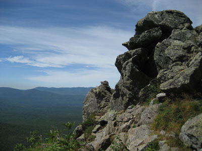
Things become rugged at the Caps - lots of rock scrambling, including the infamous ledge (that had people freaked out on my way back down - it's really not that bad, though, in dry conditions). This is also where the views opened up - with temperatures in the 50s and 60s, visibility was excellent - most of Vermont's 4,000 footers were easily spotted.
After the Cornice, things became a little bit harder to follow - the cairns blend in pretty easily with the abundance of loose rock. Nonetheless, before I knew it, I was on Mt. Jefferson.
I had the true summit to myself - there were a few people hiking on the ridge behind it, however I had the feeling I was the first one to summit Jefferson from Caps Ridge this day. The views from the summit were excellent - a bit overcast to the east, but nice in all other directions. The views from the eastern peak were also nice - the Great Gulf is quite a sight from up high!
Not having much time to kill, I quickly turned around and headed back. Crowds started the build the lower I went - by the time I reached the Caps, things were quite busy - so busy that I ended up scaling down some ledges to avoid the clogged up trail (people were having a hard time BEFORE the infamous steep ledge! Glad I wasn't around to witness them arriving there in a little while!). After the last view point (the potholes), things went pretty quickly and I was back to the parking lot just before noon. A great day for hiking!
| Hike Ratings |
|
Getting To Trailhead: |
Easy |
| Destination: |
Mt. Jefferson |
|
Length: |
Moderate |
|
Steepness: |
Very Difficult |
|
Navigation: |
Moderate |
|
Views: |
Excellent |
|
Crowds: |
Heavy |
|
| Hike Stats |
|
Date Hiked: |
Thursday, August 9, 2007 |
| Hike Commenced: |
8:18 AM |
| Parking Elevation: |
3,009' |
| Destination: |
Mt. Jefferson |
| Ascent Commenced: |
8:19 AM |
| Summit Reached: |
9:56 AM |
| Time Elapsed: |
01:37 |
| Trailhead Elevation: |
3,009' |
| Summit Elevation: |
5,712' |
| Distance: |
2.5 miles |
| Vertical Gain: |
2,768' |
|
|
| Hike Ended: |
11:54 AM |
| Hike Time Elapsed: |
03:36 |
| Hike Distance: |
5 miles |
| Hike Vertical Gain: |
2,888' |
|

Caps Ridge Trail trailhead at Jefferson Notch

Looking south at Mt. Washington over the Great Gulf from Mt. Jefferson


Directions to trailhead: Take Route 302 West from Bartlett into Carroll. Just after Saco Lake, take a right onto Mt. Clinton Road. Cross over Base Road and continue on Jefferson Notch Road. At the high point of the road, the WMNF fee parking lot will be on the right. The Caps Ridge Trail trailhead is at the back of the parking lot.
Back to Mt. Jefferson Profile
|


