Home
States
Colorado
Connecticut
Maine
Massachusetts
New Hampshire
New York
Rhode Island
Utah
Vermont
View All
Lists
NE 4,000 Footers
NE 100 Highest
NH 4,000 Footers
NH 100 Highest
NH 52 With A View
NH Belknap Range
NH Ossipee 10
Links
Trail Conditions
Trip Log
Sunrises
Sunsets
About
|
Mt. Lafayette, Mt. Truman, Mt. Lincoln, Little Haystack Mountain
Franconia, NH, Lincoln, NH
Trailheads, measurements, times, distances, and maps are all approximate and relative to the hike(s) as shown below.
Looking down the Greenleaf Trail from near the Mt. Lafayette summit
Route: Old Bridle Trail, Greenleaf Trail, Appalachian/Franconia Ridge Trail, Falling Waters Trail
My first hiked NH 4K and my first hiked 5K were both scheduled for Thursday. However, after waking up and seeing that the weather reports were botched (Wednesday was forecasted for some rain at one point, and then mostly cloudy more recently), I decided to take a half day at work a day early.
I arrived at the Lafayette Place parking lot around 12:30 and suited up. Taking the Old Bridle Path up, I was feeling pretty beat early on. Though I started wearing a sweatshirt, I quickly shedded that.
Being the highest peak I've ever climbed to date, I certainly was a bit worried, especially considering that I hadn't climbed anything significant in a few weeks (and anything at 4,000' in months). The trail was snow covered within the first mile, however the heavy traffic it recieved all winter allowed it to be barebooted without postholes. I considered putting on my Stablicers, however there were sustained stretches with only exposed ledge/rock.
Once I reached the first view points, I finally was in the groove - the Greenleaf Hut seemed to come up rather quickly at this point.
Stopping there quickly to take photos of its boarded-up glory, I continued up Mt. Lafayette, this time via the Greenleaf Trail. My pace quickly slowed due to the amazing scenery - I kept turning around and looking out at Cannon and the Green Mountains in the distance. Upon nearing the 5,000' mark, I had to stop and go into my pack (in one of the windiest parts of the hike, conveniently), to fetch out my sweatshirt again and to grab my ski poles (for navigating the small snowfield in front of me). Soon enough, I was on top of Mt. Lafayette, my first NH 4K and my first ever 5K.
The views were excellent - the Green Mountains to the west, Cannon-Kinsmans-etc. to the southwest-south, the rest of my hike due south, and Mt. Washington to the east. I spent a decent amount of time looking out this way, as two Air Force jets were putting on quite a show zipping around the Bonds.
The ascent (descent?) to Mt. Truman (labelled on the maps available at the base area, but not on TerraServer) was somewhat quick. I was a bit nervous heading over a snow headwall - knowing that if I postholed closely enough to the edge, I'd be in for quite a slide! With the exception of a small spruce trap (my first ever, do I get a medal?), the snowy portions of the trail were pretty well packed.
Mt. Truman offered similar views, with the added bonus of looking up at both Mt. Lafayette and Mt. Lincoln.
I didn't stick around long, as the wind was whipping and I wanted to git r dun.
The ascent to Mt. Lincoln was probably the trickiest of the hike, as there was some scrambling/climbing involved (not nearly as challenging as the Chin via the Long Trail on Mt. Mansfield, but certainly the steepest part of the hike), along with a little bit of black ice.
Mt. Lincoln offered better views to the south than Mt. Lafayette, despite its slightly slower summit elevation. While huddled behind a rock, eating some trail mix, I noticed a recent large mudslide off the back of Mt. Lafayette (not the rockslide on the maps). If this is indeed new, my guess is that it was within the last two weeks. If it's old, I'm an idiot.
From Mt. Lincoln, the next part of the hike was over the Gargoyles, a narrow ridge to Little Haystack Mountain. Some neat rock features about halfway between the two peaks made for an interesting hike. Due to the exposure and slightly lower elevation, there was very little snow on this stretch.
Arriving at Little Haystack Mountain, there were still nice views of Mt. Washington, Mt. Lincoln, and the peaks to the south, however Mt. Lafayette was no longer visible (Mt. Lincoln in the way).
It was finally time to head out. I took the Falling Waters Trail back to the parking lot - probably not a great idea! It was posthole city on the top part - I created a few myself too, a cold wakeup each time since I was wearing shorts. Heading toward the water crossings, the snow depths were decreasing, leading me to think the worst was over. Wrong! While walking parallel to one of the brooks, I caught my foot on a rock and went first on a buttslide, and then caught a second time, throwing me headfirst on my knees down the hill - ouch! I think there were four total water crossings - each one a bit more challenging than the previous. The last one was a bit of a doozy, as the rock crossing was pretty well submerged on one side.
Finally, though, I was back to the parking lot, and home in time for the Sox game.
| Hike Ratings |
|
Getting To Trailhead: |
Easy |
| Destination: |
Mt. Lafayette |
|
Length: |
Moderate |
|
Steepness: |
Difficult |
|
Navigation: |
Easy |
|
Views: |
Excellent |
|
Crowds: |
Minimal |
| Destination: |
Mt. Truman |
|
Length: |
Moderate |
|
Steepness: |
Moderate |
|
Navigation: |
Easy |
|
Views: |
Excellent |
|
Crowds: |
Minimal |
| Destination: |
Mt. Lincoln |
|
Length: |
Moderate |
|
Steepness: |
Very Difficult |
|
Navigation: |
Easy |
|
Views: |
Excellent |
|
Crowds: |
Minimal |
| Destination: |
Little Mt. Haystack |
|
Length: |
Difficult |
|
Steepness: |
Difficult |
|
Navigation: |
Easy |
|
Views: |
Excellent |
|
Crowds: |
Minimal |
|
| Hike Stats |
|
Date Hiked: |
Wednesday, May 2, 2007 |
| Hike Commenced: |
12:35 PM |
| Parking Elevation: |
1,770' |
| Destination: |
Mt. Lafayette |
| Ascent Commenced: |
12:37 PM |
| Summit Reached: |
3:01 PM |
| Time Elapsed: |
02:24 |
| Trailhead Elevation: |
1,785' |
| Summit Elevation: |
5,260' |
| Distance: |
4 miles |
| Vertical Gain: |
3,650' |
| Destination: |
Mt. Truman |
| Ascent Commenced: |
3:10 PM |
| Summit Reached: |
3:30 PM |
| Time Elapsed: |
00:20 |
| Trailhead Elevation: |
5,260' |
| Summit Elevation: |
5,000' |
| Vertical Gain: |
120' |
| Destination: |
Mt. Lincoln |
| Ascent Commenced: |
3:31 PM |
| Summit Reached: |
3:46 PM |
| Time Elapsed: |
00:15 |
| Trailhead Elevation: |
5,000' |
| Summit Elevation: |
5,089' |
| Vertical Gain: |
219' |
| Destination: |
Little Haystack Mountain |
| Ascent Commenced: |
3:56 PM |
| Summit Reached: |
4:22 PM |
| Time Elapsed: |
00:26 |
| Trailhead Elevation: |
5,089' |
| Summit Elevation: |
4,780' |
| Vertical Gain: |
150' |
|
|
| Hike Ended: |
5:49 PM |
| Hike Time Elapsed: |
05:14 |
| Hike Distance: |
9 miles |
| Hike Vertical Gain: |
4,354' |
|
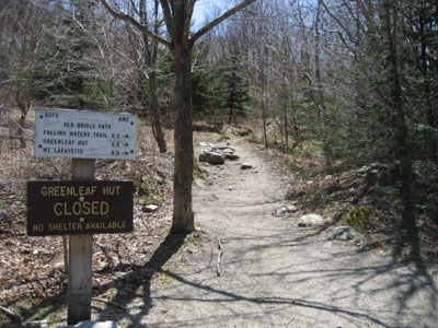
Old Bridal Path trailhead
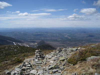
Looking northeast at Mt. Washington from the Mt. Lafayette summit

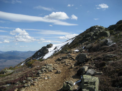
Appalachian/Franconia Ridge Trail to Mt. Truman

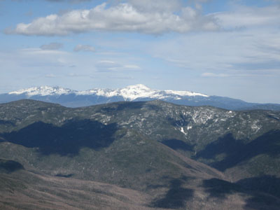
Looking southwest at Cannon Mountain from the Mt. Truman summit
Appalachian/Franconia Ridge Trail to Mt. Lincoln
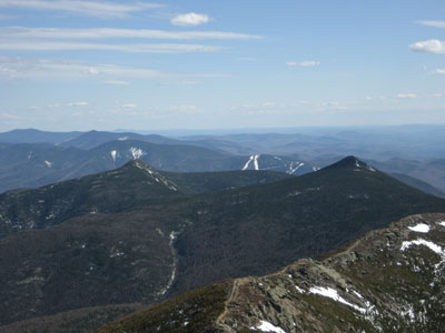
Looking south at Mt. Flume and Mt. Liberty from Mt. Lincoln
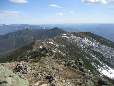
Appalachian/Franconia Ridge Trail over the Gargoyles to Little Haystack Mountain
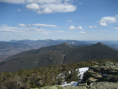
Looking south from Little Haystack Mountain
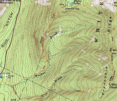

Directions to trailhead: Take Interstate 93 north from Lincoln to the Lafayette Place exit.
Back to Mt. Lafayette Profile
Back to Mt. Truman Profile
Back to Mt. Lincoln Profile
Back to Little Haystack Mountain Profile
|


