Home
States
Colorado
Connecticut
Maine
Massachusetts
New Hampshire
New York
Rhode Island
Utah
Vermont
View All
Lists
NE 4,000 Footers
NE 100 Highest
NH 4,000 Footers
NH 100 Highest
NH 52 With A View
NH Belknap Range
NH Ossipee 10
Links
Trail Conditions
Trip Log
Sunrises
Sunsets
About
|
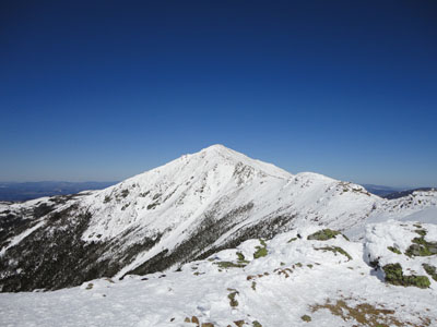
Mt. Lafayette, Mt. Truman, Mt. Lincoln, Little Haystack Mountain
Franconia, NH, Lincoln, NH
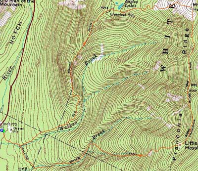
Trailheads, measurements, times, distances, and maps are all approximate and relative to the hike(s) as shown below.
Looking up the Greenleaf Trail on the way to Mt. Lafayette
Route: Old Bridle Trail, Greenleaf Trail, Appalachian/Franconia Ridge Trail, Falling Waters Trail
Though a bit windy, it seemed like a decent day for the Franconia Ridge.
We had a leisurely ascent to the hut, climbing from spring snow to packed powder. Reaching the hut, the corniced ridge was pretty impressive looking.
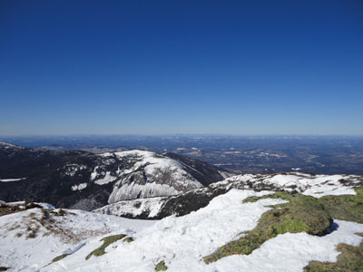
Hearing some stiffer than predicted winds, we opted to go fairly nonstop for the first portion of above treeline travel. Climbing to Lafayette resulted in walking directly into the sustained winds, slowing progress. From the summit of Lafayette, we had impressive views in all directions, including snow-covered peaks in the Green Mountains.
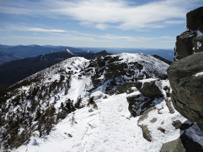
After a break from the winds in the col, we had some strong gusts as we walked over Mt. Truman. The winds were not quite as strong on Mt. Lincoln, so we opted to have some food and enjoy the views there.
Continuing to Little Haystack, we hit some strong wind gusts once again. Dropping into the trees, things were calm and spring-like.
For the descent, we broke out the short spur trail to Shining Rock, which was quite impressively covered in blue ice. Back on the Falling Waters Trail, the frozen waterfalls were also quite impressive.
| Hike Ratings |
|
Getting To Trailhead: |
Easy |
| Destination: |
Mt. Lafayette |
|
Length: |
Moderate |
|
Steepness: |
Difficult |
|
Navigation: |
Easy |
|
Views: |
Excellent |
|
Crowds: |
Heavy |
| Destination: |
Mt. Truman |
|
Length: |
Moderate |
|
Steepness: |
Moderate |
|
Navigation: |
Easy |
|
Views: |
Excellent |
|
Crowds: |
Heavy |
| Destination: |
Mt. Lincoln |
|
Length: |
Moderate |
|
Steepness: |
Very Difficult |
|
Navigation: |
Moderate |
|
Views: |
Excellent |
|
Crowds: |
Heavy |
| Destination: |
Little Haystack Mountain |
|
Length: |
Moderate |
|
Steepness: |
Difficult |
|
Navigation: |
Easy |
|
Views: |
Excellent |
|
Crowds: |
Heavy |
|
| Hike Stats |
|
Date Hiked: |
Saturday, March 6, 2010 |
| Hike Commenced: |
8:03 AM |
| Parking Elevation: |
1,770' |
| Destination: |
Mt. Lafayette |
| Ascent Commenced: |
8:04 AM |
| Summit Reached: |
11:07 AM |
| Time Elapsed: |
03:03 |
| Trailhead Elevation: |
1,785' |
| Summit Elevation: |
5,260' |
| Distance: |
4 miles |
| Vertical Gain: |
3,650' |
| Destination: |
Mt. Truman |
| Ascent Commenced: |
11:09 AM |
| Summit Reached: |
11:25 AM |
| Time Elapsed: |
00:16 |
| Trailhead Elevation: |
5,260' |
| Summit Elevation: |
5,000' |
| Vertical Gain: |
120' |
| Destination: |
Mt. Lincoln |
| Ascent Commenced: |
11:26 AM |
| Summit Reached: |
11:42 PM |
| Time Elapsed: |
00:16 |
| Trailhead Elevation: |
5,000' |
| Summit Elevation: |
5,089' |
| Vertical Gain: |
219' |
| Destination: |
Little Haystack Mountain |
| Ascent Commenced: |
11:53 AM |
| Summit Reached: |
12:18 PM |
| Time Elapsed: |
00:25 |
| Trailhead Elevation: |
5,089' |
| Summit Elevation: |
4,780' |
| Vertical Gain: |
150' |
|
|
| Hike Ended: |
1:42 PM |
| Hike Time Elapsed: |
05:39 |
| Hike Distance: |
9 miles |
| Hike Vertical Gain: |
4,424' |
|
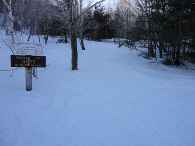
Old Bridle Path trailhead
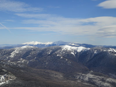
Looking northeast at Mt. Washington from the Mt. Lafayette summit

Appalachian/Franconia Ridge Trail to Mt. Truman

Looking at the Bonds from Mt. Truman
Appalachian/Franconia Ridge Trail to Mt. Lincoln
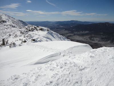
Looking south at Cannon Mountain from Mt. Lincoln
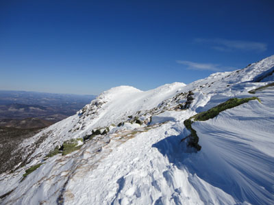
Appalachian/Franconia Ridge Trail over the Gargoyles to Little Haystack Mountain
Looking at Mt. Lincoln from Little Haystack Mountain
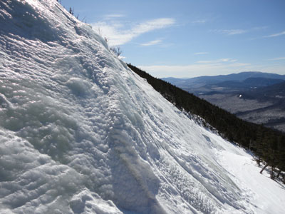
Shining Rock in winter

Directions to trailhead: Take Interstate 93 north from Lincoln to the Lafayette Place exit.
Back to Mt. Lafayette Profile
Back to Mt. Truman Profile
Back to Mt. Lincoln Profile
Back to Little Haystack Mountain Profile
|


