Home
States
Colorado
Connecticut
Maine
Massachusetts
New Hampshire
New York
Rhode Island
Utah
Vermont
View All
Lists
NE 4,000 Footers
NE 100 Highest
NH 4,000 Footers
NH 100 Highest
NH 52 With A View
NH Belknap Range
NH Ossipee 10
Links
Trail Conditions
Trip Log
Sunrises
Sunsets
About
|
Mt. Madison, Mt. Adams, Mt. Jefferson
Bean's Grant, NH, Chandler's Purchase, NH
Trailheads, measurements, times, distances, and maps are all approximate and relative to the hike(s) as shown below.
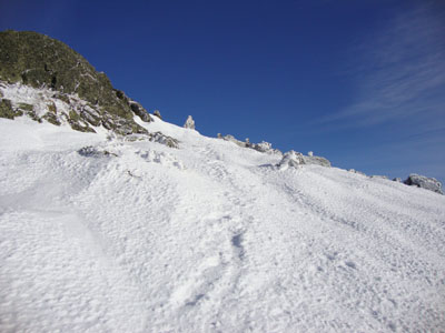
Looking up the Osgood Trail on the way to Mt. Madison
Route: Valley Way, Osgood Trail, (Mt. Madison), Osgood Trail, Gulfside Trail, Air Line Trail (with snowfield detours), (Mt. Adams), Lowe's Path, Gulfside Trail (with snowfield detours), Castle Trail, (Mt. Jefferson), Jefferson Loop, Gulfside Trail, Jewell Trail
With the forecast once again tipping in our favor, we decided to head up to the Northern Presidentials and see how far we could get. After spotting a car at the end of the slippery, but plowed Cog base station road, we were soon at Appalachia and on our way up Valley Way. Though packed, the trail was messy in places, due to postholes from barebooters.
Dropping our snowshoes at the hut, we booted up to Mt. Madison and had excellent views to the north. To the south, we could see the clouds of the winter storm that was hitting in the coastal region.
After a break next to the hut, we put on our snowshoes again and headed up to Mt. Adams, taking some snowfields rather than the lower Air Line segment. Reaching the top, we once again had great views with minimal winds. Since we had a lot more terrain to cover, we didn't linger at the summit for long.
Back on the Gulfside, we followed some trails that stayed above the trail on some snowfields. Reaching Edmands Col, we took another snack break, then followed the trails to the west of the Gulfside again, avoiding the dangerous, steep section. Reaching more snowfields, we continued to the Castle Trail, then followed it to the summit, where we once again had great views, though the southern clouds were overtaking things a bit.
After the tiring hike up to the Jewell Trail junction, we weighed our options and decided to call it a day - the clouds had overtaken the sun, the winds were increasing a bit, and we only had enough daylight to get to Washington.
The alpine zone section of the Jewell Trail was a bit tricky - one minute exposed rocks, the next snow drifts. At one point, the trail and its cairns were completely covered over with a snowfield that was leaning into the ravine - we opted to go around that portion. Once in the trees, it was a smooth hike back to the Cog base station.
| Hike Ratings |
|
Getting To Trailhead: |
Easy |
| Destination: |
Mt. Madison |
|
Length: |
Moderate |
|
Steepness: |
Difficult |
|
Navigation: |
Moderate |
|
Views: |
Excellent |
|
Crowds: |
Minimal |
| Destination: |
Mt. Adams |
|
Length: |
Moderate |
|
Steepness: |
Difficult |
|
Navigation: |
Moderate |
|
Views: |
Excellent |
|
Crowds: |
Minimal |
| Destination: |
Mt. Jefferson |
|
Length: |
Very Difficult |
|
Steepness: |
Difficult |
|
Navigation: |
Moderate |
|
Views: |
Excellent |
|
Crowds: |
Minimal |
|
| Hike Stats |
|
Date Hiked: |
Saturday, December 19, 2009 |
| Hike Commenced: |
7:49 AM |
| Parking Elevation: |
1,311' |
| Destination: |
Mt. Madison |
| Ascent Commenced: |
7:49 AM |
| Summit Reached: |
10:49 AM |
| Time Elapsed: |
03:00 |
| Trailhead Elevation: |
1,311' |
| Summit Elevation: |
5,367' |
| Vertical Gain: |
4,186' |
| Destination: |
Mt. Adams |
| Ascent Commenced: |
10:51 AM |
| Summit Reached: |
12:15 PM |
| Time Elapsed: |
01:24 |
| Trailhead Elevation: |
5,367' |
| Summit Elevation: |
5,774' |
| Vertical Gain: |
989' |
| Destination: |
Mt. Jefferson |
| Ascent Commenced: |
12:19 PM |
| Summit Reached: |
1:49 PM |
| Time Elapsed: |
01:30 |
| Trailhead Elevation: |
5,774' |
| Summit Elevation: |
5,712' |
| Vertical Gain: |
889' |
|
|
| Hike Ended: |
4:29 PM |
| Hike Time Elapsed: |
8:40 |
| Hike Vertical Gain: |
6,574' |
|
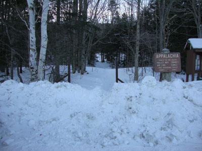
Valley Way Trail trailhead at Appalachia
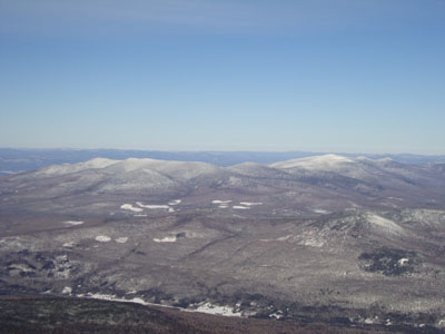
Looking at Mt. Waumbek and Mt. Cabot from Mt. Madison
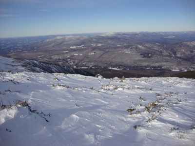
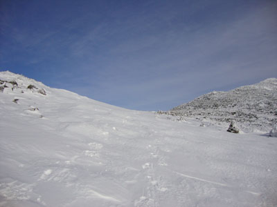
Looking down the snowfield near the Air Line on the way to Mt. Adams
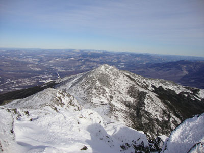
Looking at Mt. Madison from Mt. Adams
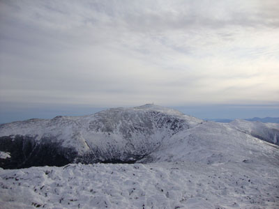
The snowfield between Mt. Adams and Mt. Jefferson
Looking at Mt. Washington from Mt. Jefferson

Directions to trailhead: To get to the Cog Base Station in winter, take 302 West from Crawford Notch, then take a right onto Base Station Road. In late fall 2009, there was plowed parking available at the Cog Base Station. To get to Appalachia from there, return to 302, then take US 3 North to 115, then US 2 East to the Appalachia parking lot and trailhead.
Back to Mt. Madison Profile
Back to Mt. Adams Profile
Back to Mt. Jefferson Profile
|


