Home
States
Colorado
Connecticut
Maine
Massachusetts
New Hampshire
New York
Rhode Island
Utah
Vermont
View All
Lists
NE 4,000 Footers
NE 100 Highest
NH 4,000 Footers
NH 100 Highest
NH 52 With A View
NH Belknap Range
NH Ossipee 10
Links
Trail Conditions
Trip Log
Sunrises
Sunsets
About
|
Mt. Shaw, Black Snoot, Big Ball Mountain
Moultonborough, NH, Tuftonboro, NH
Trailheads, measurements, times, distances, and maps are all approximate and relative to the hike(s) as shown below.

Looking up the carriage road near the Mt. Shaw summit
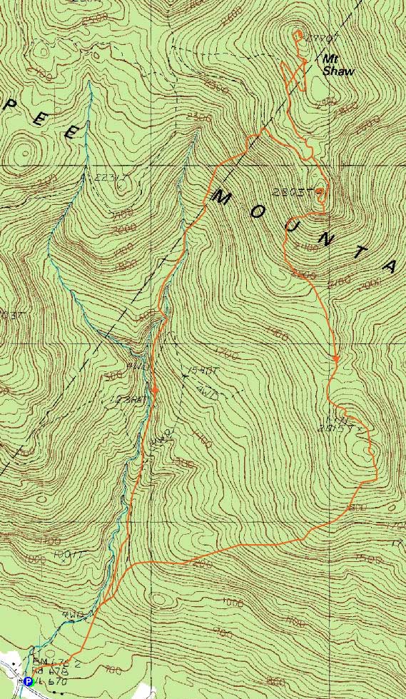
Route: Mt. Shaw Trail, Black Snout Trail, (Mt. Shaw), Black Snout Trail, Black Snout Spur Trail, (Black Snout), Black Snout Spur Trail, Banana Trail, (Big Ball Mountain), Banana Trail, Tate Mountain Trail, Mt. Shaw Trail
Next up on the trail clean up list was the Mt. Shaw loop.
The lower part of the Mt. Shaw Trail was fairly icy in places, but the damage from the storm wasn't too bad. The upper water crossings, on the other hand, were a little tricky, due to higher water levels and ice covered rocks.
Just as the steeps started, so did the blowdowns. While I was quickly losing energy, I decided to push on without stopping for a break. Arriving at the carriage road, I paused briefly to add layers (higher winds) and have a few pieces of chocolate, before diving into the absolute mess of branches and trees down. While there hadn't been much snow on the Mt. Shaw Trail, there was upwards of a foot or so of snow under a bulletproof crust of ice at this point.
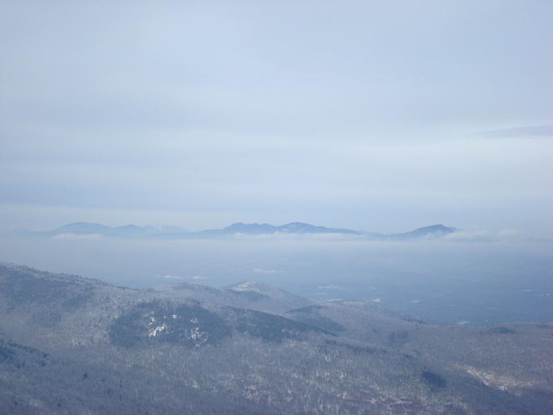
Finally reaching the Mt. Shaw summit, the views were quite neat - though my opportunity for blue sky had passed while I was clearing blowdowns on the Mt. Shaw Trail, I was nonetheless rewarded by a neat undercast in front of the Sandwich Range.
On the way over to Black Snoot, I stopped to remove one last set of blowdowns I had left during the ascent - a particularly bad bunch, it took me quite awhile to clear these.
Black Snoot was rather icy, but featured some neat views of the lake, with some quasi-sunset colors showing through. Beyond Black Snoot, however, was some very challenging trail. The runoff from the rain had frozen solid on the Banana Trail - I quickly learned that my Microspikes were not invincible like I had once hoped. Instead, I was holding onto trees and looking for alternate ways down (lots of ledge, so not an easy bushwhack per se with the amount of ice).
Finally at Big Ball Mountain, I could see a potentially good sunset in the making. Still having another 1.7 miles of trail to clean up, I chose to continue on and wait until I was at the Tate Mountain Trail before I had lunch.
The steep dip between the peaks of Big Ball Mountain was particularly challenging - the main trail scramble and the bypass were both covered in thick ice. I'm still not quite sure how I made it up that - perhaps I'll have to find a non-ledge bushwhack route to get around this until spring. Beyond this, the ledges were quite icy - a few times my Microspikes gave way, changing from traction to skates, thus depositing me on the ground.
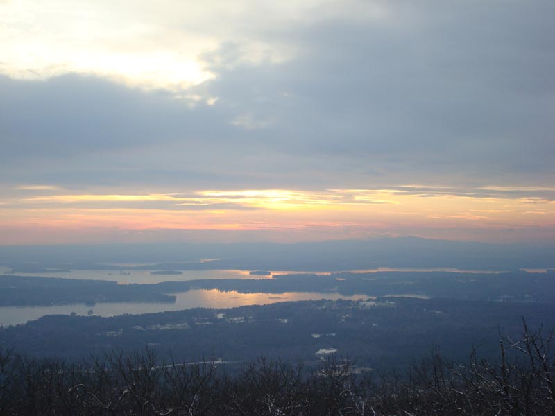
After having my lunch (early dinner, really), I made my way down the Tate Mountain Trail, with the backdrop of some beautiful sunset colors.
| Hike Ratings |
|
Getting To Trailhead: |
Moderate |
| Destination: |
Mt. Shaw |
|
Length: |
Moderate |
|
Steepness: |
Difficult |
|
Navigation: |
Moderate |
|
Views: |
Excellent |
|
Crowds: |
Minimal |
| Destination: |
Black Snoot |
|
Length: |
Moderate |
|
Steepness: |
Easy |
|
Navigation: |
Easy |
|
Views: |
Excellent |
|
Crowds: |
Minimal |
| Destination: |
Big Ball Mountain |
|
Length: |
Moderate |
|
Steepness: |
Difficult |
|
Navigation: |
Easy |
|
Views: |
Excellent |
|
Crowds: |
Minimal |
|
| Hike Stats |
|
Date Hiked: |
Sunday, December 14, 2008 |
| Hike Commenced: |
9:01 AM |
| Parking Elevation: |
670' |
| Destination: |
Mt. Shaw |
| Ascent Commenced: |
9:01 AM |
| Summit Reached: |
1:16 PM |
| Time Elapsed: |
04:15 |
| Trailhead Elevation: |
675' |
| Summit Elevation: |
2,990' |
| Distance: |
3.6 miles |
| Vertical Gain: |
2,395' |
| Destination: |
Black Snoot |
| Ascent Commenced: |
1:17 PM |
| Summit Reached: |
2:16 PM |
| Time Elapsed: |
00:59 |
| Trailhead Elevation: |
2,990' |
| Summit Elevation: |
2,803' |
| Vertical Gain: |
98' |
| Destination: |
Big Ball Mountain |
| Ascent Commenced: |
2:17 PM |
| Summit Reached: |
3:31 PM |
| Time Elapsed: |
01:14 |
| Trailhead Elevation: |
2,990' |
| Summit Elevation: |
2,803' |
| Vertical Gain: |
160' |
|
|
| Hike Ended: |
4:45 PM |
| Hike Time Elapsed: |
07:44 |
| Hike Vertical Gain: |
2,728' |
|

Mt. Shaw Trail trailhead just off Route 171

Looking at the Sandwich Range from the Mt. Shaw summit

Looking up the Black Snout Spur Trail

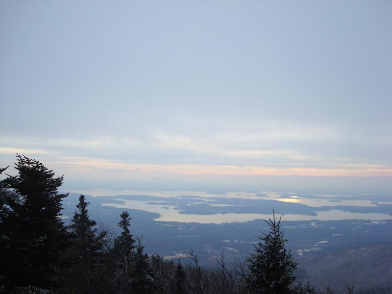
Looking at Lake Winnipesaukee from the Black Snoot summit

Looking down the icy Banana Trail below Black Snoot

Looking at Lake Winnipesaukee from the Big Ball Mountain summit

The sunset as seen from the Tate Mountain Trail on the shoulder of Big Ball Mountain


Directions to trailhead: Take 171 southeast from Route 25, past Castle in the Clouds. Shortly after crossing the Tuftonboro town line, there is a bridge/brook crossing. Immediately after this, there is an informal parking lot on the left (maybe 4 cars). The unmarked trail starts at the back of this lot.
Back to Mt. Shaw Profile
Back to Black Snoot Profile
Back to Big Ball Mountain Profile
|