Home
States
Colorado
Connecticut
Maine
Massachusetts
New Hampshire
New York
Rhode Island
Utah
Vermont
View All
Lists
NE 4,000 Footers
NE 100 Highest
NH 4,000 Footers
NH 100 Highest
NH 52 With A View
NH Belknap Range
NH Ossipee 10
Links
Trail Conditions
Trip Log
Sunrises
Sunsets
About
|
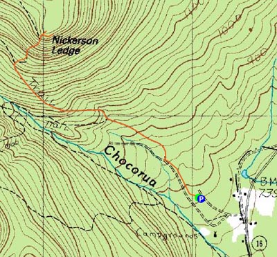
Nickerson Ledge
Albany, NH
Trailheads, measurements, times, distances, and maps are all approximate and relative to the hike(s) as shown below.
Looking up the Nickerson Ledge Trail near the vista
Route: Piper Trail, Nickerson Ledge Trail, bushwack, (Nickerson Ledge), bushwack, Nickerson Ledge Trail, Piper Trail
On the one year anniversary of my knee injury, I decided to take it easy. Nickerson Ledge looked to be a somewhat short, local hike.
Arriving at a nearly empty Piper parking lot, I quickly set off on the Piper Trail, hopping around the initial muddy section before making decent time on the dry flats.
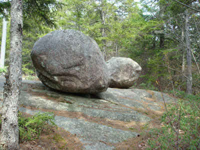
The Nickerson Ledge Trail splits off after about 1.2 miles and ascends rather steeply, prior to arriving at two large boulders. The high point is a bit beyond the boulders and the actual ledge view is a bit below those.
I was hoping for really good views and was somewhat let down, as it's basically a directional view to the south. Nonetheless, it's still nice. Destination for a hike? Probably not. Worthwhile stopping at while in route to a larger hike (perhaps the Three Sisters)? Certainly.
| Hike Ratings |
|
Getting To Trailhead: |
Easy |
| Destination: |
Nickerson Ledge |
|
Length: |
Moderate |
|
Steepness: |
Difficult |
|
Navigation: |
Easy |
|
Views: |
Excellent |
|
Crowds: |
Minimal |
|
| Hike Stats |
|
Date Hiked: |
Wednesday, May 7, 2008 |
| Hike Commenced: |
3:25 PM |
| Parking Elevation: |
780' |
| Destination: |
Nickerson Ledge |
| Ascent Commenced: |
3:26 PM |
| Summit Reached: |
3:58 PM |
| Time Elapsed: |
00:32 |
| Trailhead Elevation: |
780' |
| Summit Elevation: |
1,670' |
| Distance: |
1.4 miles |
| Vertical Gain: |
910' |
|
|
| Hike Ended: |
4:40 PM |
| Hike Time Elapsed: |
01:15 |
| Hike Vertical Gain: |
930' |
|
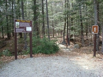
Piper Trail trailhead
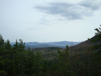
Looking south at the Mt. Whittier ski area (Nickerson Mountain) and the real Mt. Whittier from Nickerson Ledge

Directions to trailhead: Take Route 16 North from Tamworth. The Piper Trail WMNF sign is on the left, immediately after a general store. The WMNF fee parking area is about a minute or off Route 16. The Piper Trail trailhead is at the back corner of the parking lot.
Back to Nickerson Ledge Profile
|

