Home
States
Colorado
Connecticut
Maine
Massachusetts
New Hampshire
New York
Rhode Island
Utah
Vermont
View All
Lists
NE 4,000 Footers
NE 100 Highest
NH 4,000 Footers
NH 100 Highest
NH 52 With A View
NH Belknap Range
NH Ossipee 10
Links
Trail Conditions
Trip Log
Sunrises
Sunsets
About
|
Nickerson Mountain
West Ossipee, NH
Trailheads, measurements, times, distances, and maps are all approximate and relative to the hike(s) as shown below.
Looking down the access road
I've been wanting to check out Nickerson Mountain for almost a decade. After browsing around a Geocaching site, I found some data about a cache somewhere on Nickerson.
Parking at the end of the plowed section of Gilman Valley Road (just before where the snowmobile trail crosses), I put on my snowshoes and headed a bit further toward the gated access road. Though there were no snowmobiling signs, it appeared that someone had illegally gone right over the gate and headed up the mountain.
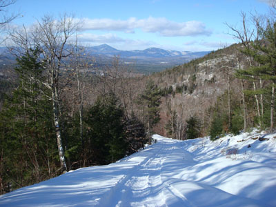
After heading through the open area, the access road steepens up a bit - and features great views of the Sandwich Range. Though it traverses across the back of the mountain, there are still some pitches that will work up a sweat.
Arriving at the summit, I was amazed how much the gondola terminal had fallen apart. I was also glad that there was a decent amount of snow on the ground, as I could see there was a lot of junk laying around that I wouldn't want to step on.
Though there is no superb viewpoint, there were decent views from a ledge near the building, a point down the liftline a bit, and a somewhat open field on the other side of the communications tower.
After snapping some photos of ski history, I decided to call it a day and head back.
| Hike Ratings |
|
Getting To Trailhead: |
Difficult |
| Destination: |
Nickerson Mountain |
|
Length: |
Moderate |
|
Steepness: |
Difficult |
|
Navigation: |
Moderate |
|
Views: |
Excellent |
|
Crowds: |
Minimal |
|
| Hike Stats |
|
Date Hiked: |
Friday, January 25, 2008 |
| Hike Commenced: |
1:31 PM |
| Parking Elevation: |
540' |
| Destination: |
Nickerson Mountain |
| Ascent Commenced: |
1:37 PM |
| Summit Reached: |
2:17 PM |
| Time Elapsed: |
00:40 |
| Trailhead Elevation: |
580' |
| Summit Elevation: |
1,700' |
| Vertical Gain: |
1,135' |
|
|
| Hike Ended: |
3:20 PM |
| Hike Time Elapsed: |
01:49 |
| Hike Vertical Gain: |
1,250' |
|

The access road on Gilman Valley Road

Looking northwest at Mt. Whiteface and Mt. Passaconaway from near the top of Nickerson Mountain


Directions to trailhead: Take Route 25 West from Route 16, then take a left onto Gilman Valley Road.
Back to Nickerson Mountain Profile
|

