Home
States
Colorado
Connecticut
Maine
Massachusetts
New Hampshire
New York
Rhode Island
Utah
Vermont
View All
Lists
NE 4,000 Footers
NE 100 Highest
NH 4,000 Footers
NH 100 Highest
NH 52 With A View
NH Belknap Range
NH Ossipee 10
Links
Trail Conditions
Trip Log
Sunrises
Sunsets
About
|
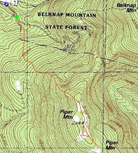
Piper Mountain
Gilford, NH
Trailheads, measurements, times, distances, and maps are all approximate and relative to the hike(s) as shown below.

Looking up the Piper Mountain Trail
Route: Piper Mountain Trail, green blazed trail, bushwhack, green blazed trail, Piper Mountain Trail
While my original intention had been to hike Mt. Tecumseh, the mostly sunny weather forecast had resulted in a mostly cloudy day. Thinking my best chance for any sort of sunset color would be at the lower elevations, I headed down to the Belknaps.
Parking near the gate on the carriage road, I donned my snowshoes - while the frozen granular and ice surfaces would have otherwise warranted Microspikes, I planned to do some light bushwhacking in the higher elevations and had no interest in lugging my snowshoes on my pack.
The water crossing at the beginning of the trail was a bit tricky due to the recent rain. Beyond there, it was fairly smooth sailing up to the ridge. While the skies were still mostly cloudy, I could see blue sky appearing in places. Views were fairly strong in all directions, though the clouds obscured the distance western horizon a bit.
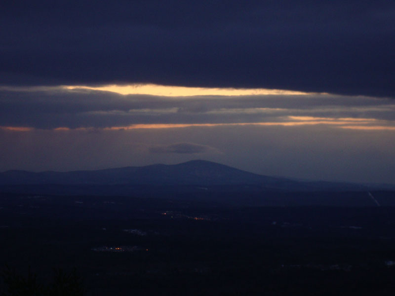
After passing over the summit, I continued south in hopes of finding a good sunset perspective. While I found a few halfway decent places, I found none of them satisfactory (nor did I find the impending display, or lack thereof, too promising). Heading back toward the summit, I lightly bushwhacked westward and found myself on some very nice ledges with a perfect view of the bland sunset display. While there were some nice colors to the south, they were too dim for the camera to capture.
With cold winds blowing, I decided to not linger overly long after the sunset. The waning moon almost full, I was able to walk down without needing a headlamp.
| Hike Ratings |
|
Getting To Trailhead: |
Easy |
| Destination: |
Piper Mountain |
|
Length: |
Moderate |
|
Steepness: |
Moderate |
|
Navigation: |
Easy |
|
Views: |
Excellent |
|
Crowds: |
Minimal |
|
| Hike Stats |
|
Date Hiked: |
Wednesday, January 27, 2010 |
| Hike Commenced: |
3:51 PM |
| Parking Elevation: |
1,030' |
| Destination: |
Piper Mountain |
| Ascent Commenced: |
3:53 PM |
| Summit Reached: |
4:27 PM |
| Time Elapsed: |
00:34 |
| Trailhead Elevation: |
1,010' |
| Summit Elevation: |
2,044' |
| Vertical Gain: |
1,064' |
|
|
| Hike Ended: |
5:40 PM |
| Hike Time Elapsed: |
01:49 |
| Hike Vertical Gain: |
1,264' |
|

The Piper Mountain Trail trailhead on the Carriage Road

Looking at Lake Winnipesaukee from near the Piper Mountain summit

Slight sunset colors around Kearsarge Mountain as seen from near the summit of Piper Mountain


Directions to trailhead: From Route 11A East (from Route 3), take a right on Hoyt Road. Continue down this road as it becomes Belknap Mountain Road. Look for Carriage Road on your left. There is a small parking lot just before the gate. Trailhead is down the road a bit, on the right after a small bridge.
Back to Piper Mountain Profile
|