Home
States
Colorado
Connecticut
Maine
Massachusetts
New Hampshire
New York
Rhode Island
Utah
Vermont
View All
Lists
NE 4,000 Footers
NE 100 Highest
NH 4,000 Footers
NH 100 Highest
NH 52 With A View
NH Belknap Range
NH Ossipee 10
Links
Trail Conditions
Trip Log
Sunrises
Sunsets
About
|
Red Hill
Moultonborough, NH
Trailheads, measurements, times, distances, and maps are all approximate and relative to the hike(s) as shown below.

Heading up the Red Hill Trail to the Red Hill summit
Route: Red Hill Trail
Despite the overcast skies, I decided to hike Red Hill after work. Upon reaching the trailhead, the clouds moved away, making for a mostly sunny hike.
The trail was well packed from foot traffic, so I hiked with just Stablicers.
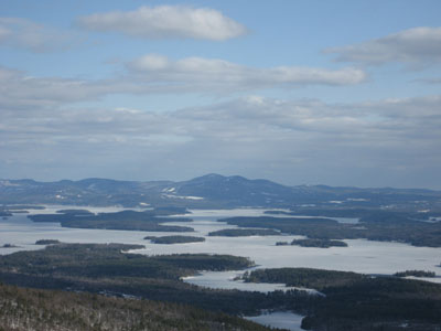
The steepest part of the hike was near the beginning - thereafter its an easy to moderate ascent. The woods are filled with small growth, making for somewhat of an ugly hike in the winter - that is, until about halfway up. From there, the lakes and mountains become visible.
The summit fire tower has a closed cab, however there is a nice platform just below it with views of the southern Whites, Mt. Cardigan, Mt. Kearsarge (South), and Belknap Mountain.
| Hike Ratings |
|
Getting To Trailhead: |
Easy |
| Destination: |
Red Hill |
|
Length: |
Moderate |
|
Steepness: |
Moderate |
|
Navigation: |
Easy |
|
Views: |
Excellent |
|
Crowds: |
Minimal |
|
| Hike Stats |
|
Date Hiked: |
Tuesday, April 10, 2007 |
| Hike Commenced: |
4:18 PM |
| Parking Elevation: |
635' |
| Destination: |
Red Hill |
| Ascent Commenced: |
4:19 PM |
| Summit Reached: |
5:01 PM |
| Time Elapsed: |
00:42 |
| Trailhead Elevation: |
640' |
| Summit Elevation: |
2,033' |
| Distance: |
1.7 miles |
| Vertical Gain: |
1,398' |
|
|
| Hike Ended: |
5:55 PM |
| Hike Time Elapsed: |
01:37 |
| Hike Distance: |
3.4 miles |
| Hike Vertical Gain: |
1,408' |
|

Red Hill Trail trailhead
Looking southeast at Mt. Rowe and Belknap Mountain


Directions to trailhead: Take Red Hill Road north from Route 25 near Center Harbor. Parking area and trailhead are on the right shortly after passing Sibley Road on the left.
Back to Red Hill Profile
|

