Home
States
Colorado
Connecticut
Maine
Massachusetts
New Hampshire
New York
Rhode Island
Utah
Vermont
View All
Lists
NE 4,000 Footers
NE 100 Highest
NH 4,000 Footers
NH 100 Highest
NH 52 With A View
NH Belknap Range
NH Ossipee 10
Links
Trail Conditions
Trip Log
Sunrises
Sunsets
About
|
Sentinel Mountain, Canaan Mountain, Mt. Flag, Mt. Shaw, Black Snoot
Ossipee, NH, Tuftonboro, NH
Trailheads, measurements, times, distances, and maps are all approximate and relative to the hike(s) as shown below.

Looking up Mountain Trail
Route: Mountain Trail, (Sentinel Mountain), unknown trail, Dave Green Trail, Canaan Mountain Trail, bushwack, (Canaan Mountain), bushwack, Mt. Flagg Trail, (Mt. Flagg), Gorilla Trail, (Mt. Shaw), High Ridge Trail, herd path, Black Snout Trail, Black Snout Spur, (Black Snoot), Black Snout Spur, Thunderbird Trail, McDuffee Road
A rarity for me, today's hike was a traverse. While our planned route could have been done as a loop with a somewhat reasonable roadwalk, I thought it was a decent idea to do a carspot, as some earlier weather forecasts (which would prove to be incorrect, surprise?) had predicted afternoon thunderstorms.
After spotting vehicles at the beginning of McDuffee Road, we parked at the Mountain Trail (Sentinel) trailhead - only a mile plus by air, but a good 20 or so minutes by open road.
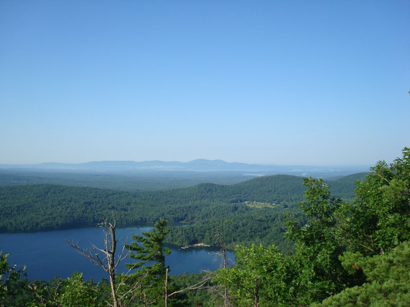
The Mountain Trail segment went by fairly quickly, as we ascended to the Sentinel Ledges in nice, sunny weather. Though a little bit hazy, the lake views were nonetheless great.
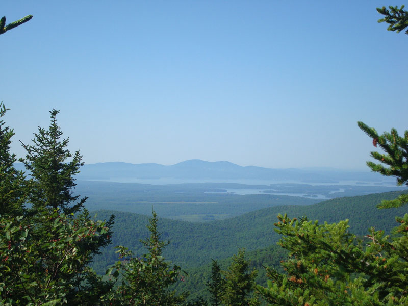
After spending some time at that summit, we took a seldom used (though well blazed) trail from Sentinel Mountain over another set of ledges, then continued up the Canaan Mountain Trail. Near a height of land on this trail, we did a bushwack up to the summit of Canaan Mountain - other than the final part of the ascent, the bushwack was fairly straightforward. Though wooded, the summit of Canaan Mountain provided some nice lake views.
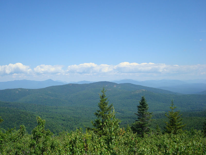
Rather than backtrack, we did a thicker bushwack over to the Mt. Flagg Trail. From the trail, it was a short walk up to the ledges and then to the summit - excellent views from both.
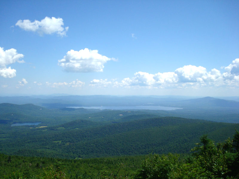
The next stop was Mt. Shaw. While well blazed, the Gorilla Trail doesn't appear to get much traffic, as ferns and grass are growing tall. The views from the summit of Mt. Shaw were excellent - a great place for a quick lunch.
After Mt. Shaw, we decided to head over to Black Snoot for some lake views. From there, we backtracked to the Black Snout Spur Trail junction and headed down the Thunderbird Trail. The Thunderbird Trail was well blazed, though a bit wet up high due to the recent rainy stretch. The upper portions of the trail were rather steep, though down low the trail became a more gradual woods road.
Near the bottom of the trail/woods road, we checked out a neat waterfall - certainly a bit impressive with the increased waterflow of late.
After reaching a gate at the end of the trail, we did the roadwalk down McDuffee Road, back to our spotted cars. A great hike with, despite the forecasters best attempts in previous days to deter us, great weather.
| Hike Ratings |
|
Getting To Trailhead: |
Easy |
| Destination: |
Sentinel Mountain |
|
Length: |
Moderate |
|
Steepness: |
Difficult |
|
Navigation: |
Easy |
|
Views: |
Excellent |
|
Crowds: |
Minimal |
| Destination: |
Canaan Mountain |
|
Length: |
Moderate |
|
Steepness: |
Difficult |
|
Navigation: |
Difficult |
|
Views: |
Moderate |
|
Crowds: |
Minimal |
| Destination: |
Mt. Flagg |
|
Length: |
Moderate |
|
Steepness: |
Difficult |
|
Navigation: |
Difficult |
|
Views: |
Excellent |
|
Crowds: |
Minimal |
| Destination: |
Mt. Shaw |
|
Length: |
Moderate |
|
Steepness: |
Difficult |
|
Navigation: |
Easy |
|
Views: |
Excellent |
|
Crowds: |
Minimal |
| Destination: |
Black Snoot |
|
Length: |
Moderate |
|
Steepness: |
Easy |
|
Navigation: |
Easy |
|
Views: |
Excellent |
|
Crowds: |
Moderate |
|
| Hike Stats |
|
Date Hiked: |
Saturday, July 26, 2008 |
| Hike Commenced: |
7:36 AM |
| Parking Elevation: |
885' |
| Destination: |
Sentinel Mountain |
| Ascent Commenced: |
7:37 AM |
| Summit Reached: |
8:03 AM |
| Time Elapsed: |
00:26 |
| Trailhead Elevation: |
890' |
| Summit Elevation: |
1,680' |
| Vertical Gain: |
805' |
| Destination: |
Canaan Mountain |
| Ascent Commenced: |
8:14 AM |
| Summit Reached: |
9:25 AM |
| Time Elapsed: |
01:11 |
| Trailhead Elevation: |
1,680' |
| Summit Elevation: |
2,072' |
| Vertical Gain: |
632' |
| Destination: |
Mt. Flagg |
| Ascent Commenced: |
9:28 AM |
| Summit Reached: |
10:42 AM |
| Time Elapsed: |
01:14 |
| Trailhead Elevation: |
2,072' |
| Summit Elevation: |
2,390' |
| Vertical Gain: |
490' |
| Destination: |
Mt. Shaw |
| Ascent Commenced: |
10:50 AM |
| Summit Reached: |
11:48 AM |
| Time Elapsed: |
00:29 |
| Trailhead Elevation: |
2,390' |
| Summit Elevation: |
2,990' |
| Vertical Gain: |
800' |
| Destination: |
Black Snout |
| Ascent Commenced: |
12:11 PM |
| Summit Reached: |
12:30 PM |
| Time Elapsed: |
00:19 |
| Trailhead Elevation: |
2,990' |
| Summit Elevation: |
2,803' |
| Vertical Gain: |
98' |
|
|
| Hike Ended: |
2:09 PM |
| Hike Time Elapsed: |
06:33 |
| Hike Vertical Gain: |
2,880 |
|

The Mountain Trail trailhead

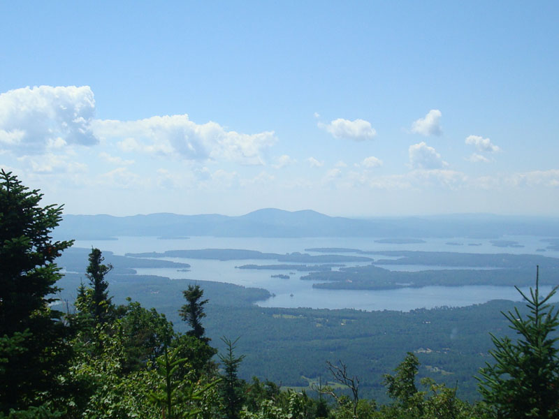
Looking southwest at the Belknap Range from the ledges of Sentinel Mountain

Looking down the trail between the Merrowvista Ledges and Sentinel Mountain

Looking southwest at the Belknap Range from Canaan Mountain

Looking up the Mt. Flagg Trail at the Mt. Flagg ledges

Looking north at the northern Ossipees and the eastern Sandwich Range from the Mt. Flagg summit

Looking up the Gorilla Trail on the way to Mt. Shaw

Looking at Ossipee Lake from the Mt. Shaw summit

Looking up the High Ridge Trail near the summit of Mt. Shaw

Looking southwest at the Belknap Range from Black Snoot


Directions to trailhead: From Route 16 South in West Ossipee, take a left onto Old NH 16. After crossing under Route 16, take a right onto Folsom Road. Once in Center Ossipee, take a right onto Moultonville Road. A few minutes later, take a right onto Valley Road. Look for the entrance to Terrace Pines Campground, which will be on the right when Valley Road forks. Shortly down this road, take a right (immediately before a sign for the office). There is limited room for parking in front of the gate - do not block the gate. The Mountain Trail starts a few dozen feet beyond the gate, on the left. To get to the Thunderbird Trail, take 171 southeast from Route 25, past Castle in the Clouds. Take a left onto Canaan Road. There is some room to park at the junction of Canaan Road and McDuffee Road. The Thunderbird Trail ends on a logging road, which then ends at a gate on a curve on the McDuffee Trail.
Back to Sentinel Mountain Profile
Back to Canaan Mountain Profile
Back to Mt. Flagg Profile
Back to Mt. Shaw Profile
Back to Black Snoot Profile
|