Home
States
Colorado
Connecticut
Maine
Massachusetts
New Hampshire
New York
Rhode Island
Utah
Vermont
View All
Lists
NE 4,000 Footers
NE 100 Highest
NH 4,000 Footers
NH 100 Highest
NH 52 With A View
NH Belknap Range
NH Ossipee 10
Links
Trail Conditions
Trip Log
Sunrises
Sunsets
About
|
South Twin Mountain, North Twin Mountain, Galehead Mountain
Bethlehem, NH, Franconia, NH
Trailheads, measurements, times, distances, and maps are all approximate and relative to the hike(s) as shown below.

Looking down the Twinway near South Twin
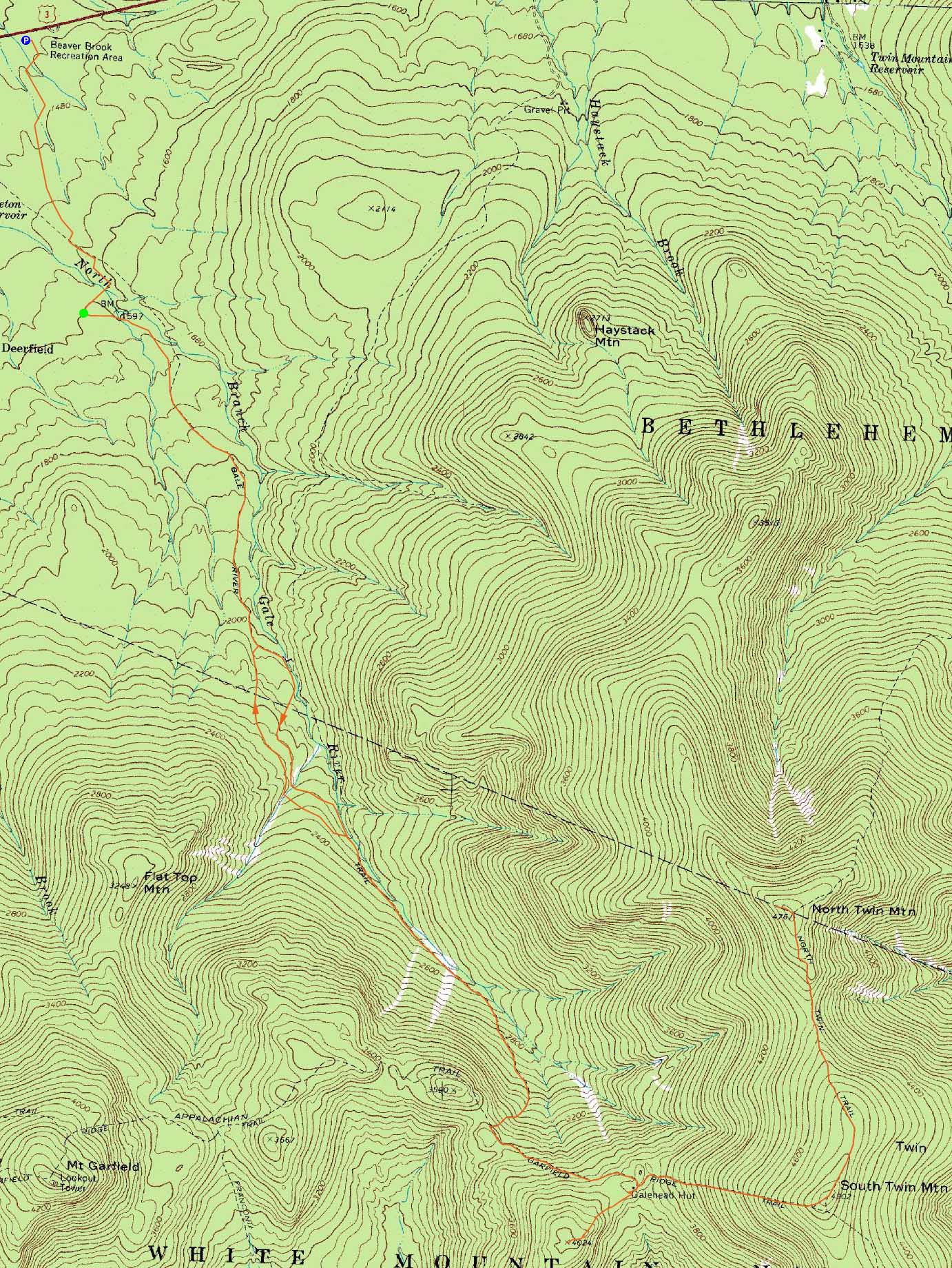
Route: Beaver Brook XC Ski Trail, connector trail, Gale River Road, Gale River Trail, bushwhack, Gale River Trail, Garfield Ridge Trail, (Galehead Hut), Twinway, (South Twin), North Twin Spur, (North Twin Mountain), North Twin Spur, (South Twin Mountain), Twinway, Frost Trail, (Galehead Mountain), Frost Trail, Garfield Ridge Trail, Gale River Trail, bushwhack, Gale River Trail, Gale River Road, connector trail, Beaver Brook XC Ski Trail
With extremely warm temperatures forecasted, it wasn't a great day to be hiking anything with water crossings. While it can be much easier to hike the Twins and Galehead via a traverse, we opted to do an out-and-back and perhaps bushwhack around tough water crossings.
With Gale River Road closed (despite being snow free and dry), we hiked in from Beaver Brook. Shortly after starting up the Gale River Trail, we were presented with our first crossing - often a simple rockhop, it was running quite high and required some fancy footwork.
Eventually reaching the first Gale River crossing (still snow-free conditions), it was pretty clear we wouldn't be able to get across, due to the high and fast current. Moving to plan B, we bushwhacked along the shore for awhile, before climbing up the embankment into more open woods (and crossing what appeared to be the proposed reroute of the Gale River Trail). It was fairly smooth (though wet) sailing up here, until we neared Garfield Stream. At that point, we had to push through extremely thick spruce while dropping down the steep northern side of the gully. Though high, the crossing was doable with care.
Dropping back down a bit too quickly, we soon donned snowshoes and eventually reached the Gale River Trail. Due to the terrain, snowshoe swaps, and crossing, what would be a .8 mile trailwalk turned into a 1.5 hour bushwhack.
Reaching the hut, we opted to split up our group - some of us stayed to eat lunch while others went direct to South Twin. After a warm lunch stop (temperatures perhaps around 80 degrees), we headed up to South Twin (fortunately, no ice patches had formed on the trail yet), where we were greeted with excellent (though hazy) views.
After an extended stay, we headed to North Twin. The North Twin Spur was quite difficult to follow from below the South Twin scrub to the col. Reaching the summit, we had views in all directions, thanks to the snowpack. After another short break, we headed back to South Twin, and then down to the hut.
Beyond the hut, the route to Galehead was tough to follow, due to various snow monorails weaving through sprucetraps. Eventually reaching the summit, we had some slight views of the Franconia Ridge from the highpoint, and additional views from near it. For the descent back to the hut, we opted to follow the trail proper, rather than the tracks of previous visitors.
For the descent, we took a look at the second Gale River crossing and decided to bushwhack once again. This time, we opted to climb a bit higher up and avoid the spruce and bad footing along the riverside. The Garfield Stream had climbed during the day, resulting in knee deep wading. Nonetheless, we made it back to the trail and summer parking lot in daylight.
| Hike Ratings |
|
Getting To Trailhead: |
Difficult |
| Destination: |
South Twin Mountain |
|
Length: |
Difficult |
|
Steepness: |
Difficult |
|
Navigation: |
Difficult |
|
Views: |
Excellent |
|
Crowds: |
Minimal |
| Destination: |
North Twin Mountain |
|
Length: |
Difficult |
|
Steepness: |
Difficult |
|
Navigation: |
Difficult |
|
Views: |
Excellent |
|
Crowds: |
Minimal |
| Destination: |
South Twin Mountain |
|
Length: |
Difficult |
|
Steepness: |
Difficult |
|
Navigation: |
Difficult |
|
Views: |
Excellent |
|
Crowds: |
Minimal |
| Destination: |
Galehead Mountain |
|
Length: |
Very Difficult |
|
Steepness: |
Difficult |
|
Navigation: |
Difficult |
|
Views: |
Excellent |
|
Crowds: |
Minimal |
|
| Hike Stats |
|
Date Hiked: |
Saturday, April 3, 2010 |
| Hike Commenced: |
7:34 AM |
| Parking Elevation: |
1,420' |
| Destination: |
South Twin Mountain |
| Ascent Commenced: |
7:59 AM |
| Summit Reached: |
1:02 PM |
| Time Elapsed: |
05:03 |
| Trailhead Elevation: |
1,610' |
| Summit Elevation: |
4,902' |
| Vertical Gain: |
3,692' |
| Destination: |
North Twin Mountain |
| Ascent Commenced: |
1:27 PM |
| Summit Reached: |
2:14 PM |
| Time Elapsed: |
00:47 |
| Trailhead Elevation: |
4,902' |
| Summit Elevation: |
4,761' |
| Vertical Gain: |
321' |
| Destination: |
South Twin Mountain |
| Ascent Commenced: |
2:24 PM |
| Summit Reached: |
3:10 PM |
| Time Elapsed: |
00:46 |
| Trailhead Elevation: |
4,761' |
| Summit Elevation: |
4,902' |
| Vertical Gain: |
461' |
| Destination: |
Galehead Mountain |
| Ascent Commenced: |
3:20 PM |
| Summit Reached: |
3:59 PM |
| Time Elapsed: |
00:39 |
| Trailhead Elevation: |
4,902' |
| Summit Elevation: |
4,024' |
| Vertical Gain: |
309' |
|
|
| Hike Ended: |
8:03 PM |
| Hike Time Elapsed: |
12:29 |
| Hike Vertical Gain: |
5,433' |
|

The Gale River Trail trailhead

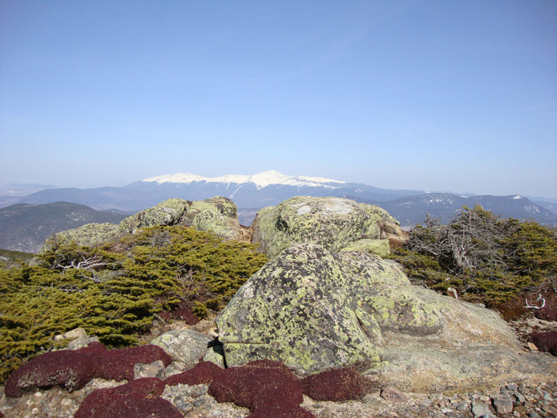
Looking at Mt. Washington from South Twin

Looking down the North Twin Spur on the way to North Twin Mountain

Looking at South Twin and into the Pemi from near the summit of North Twin

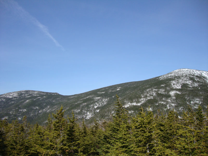
Looking up the Frost Trail to Galehead Mountain

Looking at the Twins from Galehead Mountain


Directions to trailhead: Take Route 3 South from US 302. In the winter, take a left into the Beaver Brook WMNF fee parking area, just before the five corners. Follow the Beaver Brook cross country ski trail counterclockwise (some signs directing hikers to Gale River Road). A short path will lead from the cross country ski trail to an open field and to Gale River Road (go left onto it). Take a right shortly thereafter onto the loop road. The Gale River Trail trailhead will be on the left .3 miles thereafter.
Back to South Twin Mountain Profile
Back to North Twin Mountain Profile
Back to Galehead Mountain Profile
|