Downes Brook Slide Trail
State: NH |
Also known as the Passaconaway Slide Trail, the Downes Brook Slide Trail climbed up from the Downes Brook Trail to the present day view spur on Mt. Passaconaway. The trail was illegally recleared in recent decades and now carries a fine and possible jail time if further maintenance is performed.
|
|
| Downes Brook Slide Trail Details |
|
| Also Known As: |
Passaconaway Slide Trail |
|
| Location: |
White Mountains - Sandwich |
|
| Peak: |
Mt. Passaconaway |
|
| Opened: |
1906 |
|
| Closed: |
1950s |
|
| Reason Closed: |
|
|
| Guidebook Descriptions: |
|
1931 AMC White Mountain Guide
Downes Brook Slide Trail. (P.M.C.)
This trail, ascending the mountain from the N., follows the U.S.F.S. Downes Brook Trail (see below) as far as the foot of the slide. This is the first of two roads which leave the Albany Intervale or Swift River Road about ¼ m. W. of the Swift River Inn, the first L. beyond the cottage called “Camp Paugus.” Upon reaching the foot of the slide the latter may be followed to its apex, or a logging road just beyond (S.W.) may be used as far as a sharp bend to the R. which is opposite a similar bend about halfway up the slide. Above this point the slide is steeper. This trail is not marked on the slide itself, but the way is unmistakenable. The L. side (in ascending) offers the easiest and driest footing. Care should be taken not to start rocks rolling. At the top of the slide the trail will be found again. It climbs steeply through thick woods and joins the short trail between the two outlooks on the summit.
Distances. Swift River Inn to the foot of slide 2 m. (1 hr. 15 min.); to summit 4 m. (4 hrs.).
1934 AMC White Mountain Guide
Downes Brook Slide Trail. (P.M.C.)
This trail, ascending the mountain from the N., follows the U.S.F.S. Downes Brook Trail (see below) as far as the foot of the slide. This trail leaves the Albany Intervale Road on the S., 150 yds. E. of its W. end, a short distance W. of Swift River Inn. Crossing Downes Brook four times, the trail reaches the slide on its L., 2 m. from the highway. Painted arrows now indicate the driest and easiest route up the slide. About half-way up, the slide turns sharply R. and continues more steeply to its top. Care should be taken not to start rocks rolling. From the top of the slide the trail climbs steeply through thick woods, passing a series of outlooks to the N., and joins the short trail between the two outlooks on the summit.
Distances. Swift River Inn to foot of slide 2 m. (1 hr. 15 min.) to summit 4 m. (4 hrs.).
1940 AMC White Mountain Guide
Downes Brook Slide Trail (WMNF)
This trail, ascending the mountain from the N, coincides with Downes Brook Trail (see below) as far as the foot of the slide. It leaves Albany Intervale Road on the S a short distance W of the U. of N. H. Forestry School. Crossing Downes Brook four times, the trail reaches the slide on its L, 2 m. from the road. Painted arrows now indicate the driest and easiest routes up the slide. About halfway up, the slide turns sharply R and continues more steeply to its top. Care should be taken not to start rocks rolling. From the top of the slide the trail climbs steeply through thick woods, passing a series of outlooks to the N and joins the short trail between the two outlooks on the summit.
As there is no sign where the Downes Brook Trail diverges at foot of slide, note that this slide is the first slide to be met, and is the only rock ledge slide. This trail is dangerous, especially after a rain, and is not recommended to amateur climbers. It is not signed for this reason.
Distances. U. of N.H. Forestry School to foot of slide 2 m. (1 hr. 15 min.); to summit 4 m. (4 hrs.).
1948 AMC White Mountain Guide
Downes Brook Slide Trail (WMNF)
This trail, ascending the mountain from the N, coincides with Downes Brook Trail (see below) as far as the foot of the slide. It leaves the Albany Intervale Road on the S a short distance W of the U. of N. H. Forestry School. Crossing Downes Brook four times, the trail reaches the slide on its L, 2 m. from the road. Painted arrows now indicate the driest and easiest routes up the slide. About halfway up, the slide turns sharply R and continues more steeply to its top. Care should be taken not to start rocks rolling. From the top of the slide the trail climbs steeply through thick woods, passing a series of outlooks to the N and joins the short trail between the two outlooks on the summit.
As there is no sign where the Downes Brook Trail diverges at the foot of the slide, note that this slide is the first slide to be met, and is the only rock ledge slide. This trail is dangerous, especially after a rain, and is not recommended to amateur climbers. For this reason it is not signed.
Distances. U. of N. H. Forestry School to foot of slide 2 m. (1 hr. 15 min.); summit 4 m. (4 hrs.). |
|
| Images: |
|
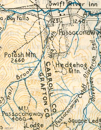
1934 AMC map of Mt. Passaconaway
|
|
| Links: |
|
| Bootleg Trails - WODC |
|
| Last updated 2011-08-20 |
| Disclaimer: Data provided for academic and historical purposes only. Respect all signs. |
|
|
