Currier Brook Trail
State: NH |
The Currier Brook Trail briefly offered a northern route to Mt. Paugus.
|
|
| Currier Brook Trail Details |
|
| Also Known As: |
|
|
| Location: |
White Mountains - Sandwich |
|
| Peak: |
Mt. Paugus |
|
| Opened: |
1930s? |
|
| Closed: |
1940s? |
|
| Reason Closed: |
|
|
| Guidebook Descriptions: |
|
1934 AMC White Mountain Guide
Currier Brook Trail. (W.M.N.F.)
Mt. Paugus may be reached from Albany Intervale by this Class 3 trail or “manway,” which leaves the S. side of the Albany Road at a sign W. of Currier Brook. It follows logging-roads nearly to the summit, crossing and recrossing the stream. At about 2 m. it passes an abandoned lumber camp and, shortly beyond, ascends the W. side of the ravine, avoiding the precipitous face of Mt. Paugus in favor of a spur. It follows this spur to the wooded summit, crosses the latter and continues S. to the open ledges and the Old Paugus Trail. Distance. 3 ½ m. (3 hrs.).
1940 AMC White Mountain Guide
Currier Brook Trail (WMNF)
Mt. Paugus may be reached from Albany Intervale by this trail which leaves the S side of the Albany Road at a sign W of Currier Brook. It follows logging-roads nearly to the summit, crossing and recrossing the stream. At about 2 m. it passes an abandoned lumber camp and, shortly beyond, ascends the W side of the ravine, avoiding the precipitous face of Mt. Paugus in favor of a spur. It follows this spur to the wooded summit, crosses it and continues S to the open ledges and the Old Paugus Trail.
Distance. 3 ½ m. (3 hrs.). |
|
| Images: |
|
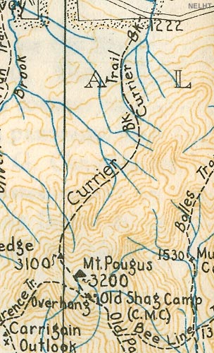
1934 AMC map of Mt. Paugus
|
|
| Links: |
|
|
|
| Last updated 2011-08-19 |
| Disclaimer: Data provided for academic and historical purposes only. Respect all signs. |
|
|
