Mexico Ridge Trail
State: NH |
|
|
| Mexico Ridge Trail Details |
|
| Also Known As: |
Ridge Trail |
|
| Location: |
White Mountains - Sandwich |
|
| Peak: |
Mt. Mexico |
|
| Opened: |
1914 |
|
| Closed: |
|
|
| Reason Closed: |
|
|
| Guidebook Descriptions: |
|
1931 AMC White Mountain Guide
Ridge Loop. (W.O.D.C.)
This trail was built in 1914 and extended in 1920. It runs from a point on the Wonalancet highway a few rods W. of the abandoned E. end of “Locke Road,” and ¼ m. W. of the Mt. Mexico Farm by-road (sign), joins the Bickford Trail to Paugus Mill for a few yards at the “Birches,” then ascends a knoll with a good view and continues up a spur of Mt. Mexico to its flat summit, where the path from Wonalancet to Big Rock Cave crosses it at ½ m. S.W. of the cave. Thence the Ridge Loop runs along the ridge to a junction with the Cabin Trail (L.) and the new Whitin Brook Trail (R.) (see above). Thence the Cabin Trail leads to the Lawrence Trail at Carrigain Outlook. There is no view of particular interest on this ridge, but the trail links up others of greater importance. There is no water after leaving the highway.
Distances. Highway to Mt. Mexico 1 3/8 m. (1 hr.); to Carrigain Outlook 3 1/8 m. (2 hrs.).
1934 AMC White Mountain Guide
Mexico Ridge Trail. (W.O.D.C.)
This trail runs from C.E. Walker’s Trail Cottage on the Chinook Highway a few roads E. of Chinook Kennels, joins the Bickford Trail to Paugus Mill for a few yds. at “The Birches,” then ascends a knoll with a good view and continues up a spur of Mt. Mexico to its flat summit. Here the Big Rock Cave Trail crosses it ½ m. S.W. of the Cave. Thence the Mexico Ridge Trail runs along the ridge to a junction with the Cabin Trail (L.) and the new Whitin Brook Trail (R.) (see above). Thence the Cabin Trail leads to the Lawrence Trail at Carrigain Outlook. There is no view of particular interest on this ridge, but the trail links up others of greater importance. There is no water after leaving the highway.
Distances. Highway to Mt. Mexico 1 3/8 m. (1 hr.); to Carrigain Outlook 3 1/8 m. (2 hrs.).
1940 AMC White Mountain Guide
Mexico Ridge Trail (WODC)
This trail runs from C.E. Walker’s Trail Cottage on the Chinook Highway a few roads E of Chinook Kennels, joins the Bickford Trail to Paugus Mill for a few yards at “The Birches,” then ascends a knoll with a good view and continues up a spur of Mt. Mexico to its flat summit. Here the Big Rock Cave Trail crosses it ½ m. SW of the Cave. Thence the Mexico Ridge Trail follows the ridge to a junction with Cabin Trail (L) and Whitin Brook Trail (R) (see above). Thence the Cabin Trail leads to the Lawrence Trail at Carrigain Outlook. There is no view of particular interest on this ridge, but the trail links others of greater importance. There is no water.
Distances. Highway to Mt. Mexico 1 3/8 m. (1 hr.); to Carrigain Outlook 3 1/8 m. (2 hrs.).
1948 AMC White Mountain Guide
Mexico Ridge Trail (WODC)
This trail runs from C. E. Walker’s Trail Cottage on the Chinook Highway a few rods E of Chinook Kennels, joins the Bickford Trail to Paugus Mill for a few yards at “The Birches,” then ascends a knoll with a good view and continues up a spur of Mt. Mexico to its flat summit. Here the Big Rock Cave Trail crosses it ½ m. SW of the Cave. Thence the Mexico Ridge Trail follows the ridge to a junction with the Cabin Trail (L) and Whitin Brook Trail (R) (see above). Thence the Cabin Trail leads to the Lawrence Trail at Carrigain Outlook. There is no view of particular interest on this ridge, but the trail links others of greater importance. There is no water.
Distances. Highway to Mt. Mexico 1 3/8 m. (1 hr.); Carrigain Outlook 3 1/8 m. (2 hrs.). |
|
| Images: |
|
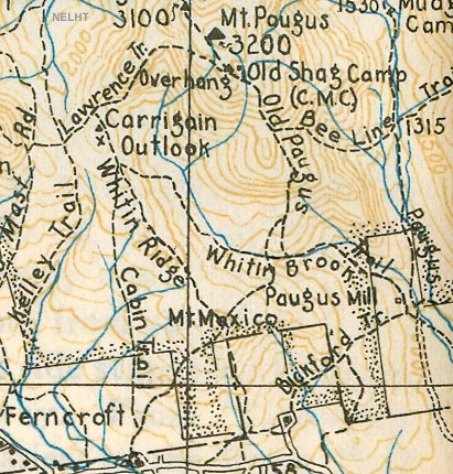
1934 AMC map of Mt. Mexico
|
|
| Links: |
|
|
|
| Last updated 2011-08-20 |
| Disclaimer: Data provided for academic and historical purposes only. Respect all signs. |
|
|
