Mount Eastman Trail (south section)
State: NH |
The present day Mount Eastman Trail roughly follows the northern portion of the former Mount Eastman Trail. The entire trail was likely abandoned in the 1940s, with only the northern portion reopening in the early 1960s.
|
|
| Mount Eastman Trail (south section) Details |
|
| Also Known As: |
|
|
| Location: |
White Mountains - Evans Notch |
|
| Peak: |
Eastman Mountain |
|
| Opened: |
1930s? |
|
| Closed: |
1940s |
|
| Reason Closed: |
|
|
| Guidebook Descriptions: |
|
1931 AMC White Mountain Guide
South Baldface and Mt. Eastman may be reached by this trail [Slippery Brook Trail] as it passes through the col between then, and this is doubtless the easiest approach to either from the S.E. But the col is full of “jackstraws” and small growth, and there is no trail to either peak. Hence, though the distances without trail are insignificant, the tramper should be provided with a vocabulary equal to the occasion.
1934 AMC White Mountain Guide
Mount Eastman Trail leaves the Mountain Pond Trail ½ m. E. of the pond, follows up McDonough Brook, crosses the Bradley Brook Trail ¼ m. E. of its junction with the Slippery Brook Trail, continues N. over Mt. Eastman and ends at the Slippery Brook Trail in the col between Eastman and S. Baldface. The Baldface Knob Trail continues N. from this same point. Distance 4.3 m.
1940 AMC White Mountain Guide
Mount Eastman Trail (WMNF)
This trail leaves the Mountain Pond Trail ½ m. E of the pond, follows up McDonough Brook, crosses the Bradley Brook Trail, continues N over Eastman and ends at the Slippery Brook Trail in the col between Eastman and South Baldface. The Baldface Knob Trail continues N from this point. 4.3 m.
1960 AMC White Mountain Guide
Mounts Sable (3,540.), Chandler (3,330 ft.) and Eastman (2,936 ft.)
The former trails over the summits of these three mountains have been abandoned. Mt. Eastman summit may be approached by the Slippery Brook and Bradley Brook Trails.
1963 AMC White Mountain Guide
For experienced trampers, a bushwhack of about 15 min., in a generally S direction, will take one to the lower (southern) summit along the old abandoned section of the former trail which ascended the mountain from the S side. This secondary summit is partially wooded, but has good outlooks in several directions.
|
|
| Images: |
|
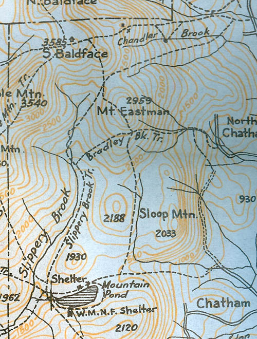
1940 AMC map of Eastman Mountain
|
|
| Links: |
|
|
|
| Last updated 2011-08-28 |
| Disclaimer: Data provided for academic and historical purposes only. Respect all signs. |
|
|
