Firewardens Trail
State: ME |
The Old Speck Firewardens Trail ascended directly from Grafton Notch to the summit of Old Speck, making it one of the steepest trails in New England. Due to the danger posed, and being part of the Appalachian Trail, it was closed and traffic rerouted to the Old Speck Trail.
|
|
| Firewardens Trail Details |
|
| Also Known As: |
|
|
| Location: |
Grafton Notch |
|
| Peak: |
Old Speck Mountain |
|
| Opened: |
1914? |
|
| Closed: |
1973 |
|
| Reason Closed: |
Steepness |
|
| Guidebook Descriptions: |
|
1931 AMC White Mountain Guide
Old Speck (Speckled Mountain). Fire-Warden’s Trail (M.F.D.)
Old Speck in Grafton, commonly so called to distinguish it from the “Speckled Mountains” in Stoneham, Maine, and in Woodstock and Reading, Maine, is one of the highest peaks in the State, with an altitude of 4,250 feet according to a recent State survey.
The trail to Old Speck leaves the W. side of the Grafton Notch Road about 6 ¾ m. N. of Poplar Tavern in North Newry and about 100 yds. N. of the fire-warden’s cabin on the W. side of the road, at a point where the road is level and a culvert bridges a small water-course (sign). Old Speck is a lookout station for M. F. D. and is connected by telephone.
The trail is almost uniformly one of the steepest in the mountains except for the first hundred yards after leaving the highway. It follows up the N.E. shoulder in a S.W. direction just N. of a brook which it crosses at the fire-warden’s cabin (last sure water). The path then bears somewhat more to the S. and attacks the main mass of the mountain. Water is usually found under a rock at the R. of the path about 1/3 m. above the brook (marked by a sign cut into a tree). The path soon crosses open rock slopes with views toward the Rangeley Lakes. The summit is flat and wooded but has vistas cut across it toward the E. and W. There is a high steel observation-tower of the fire-warden (which may be locked).
Distances. Road to Cabin ¾ m. (1 hr. 30 min.); to summit 1 1/2 m. (2 hrs. 30 min.).
In descending the tramper may leave the easterly end of the summit where a vista has been cut through the trees and follow down over the ledgey spur S. of the trail, passing through short patches of scrub and keeping near the S. edge of the spur, down which an obscure trail will be found. At the lower end of the spur, where the cliffs fall off to Grafton Notch, the main trail can be reached without difficulty by passing N. and N.W., slabbing the side of the mountain. The view from the spur toward the E. and S. is particularly good.
Old Speck is also the N. terminus of the Mahoosuc Range Trail.
1934 AMC White Mountain Guide
Old Speck. (Fire-Warden’s Trail, M.F.D.)
Old Speck in Grafton, Maine, commonly so called to distinguish it from the “Speckled Mountains” in Stoneham, Maine, and in Woodstock and Reading, Maine, is one of the highest peaks in the State, with an altitude of 4,250 feet according to a recent State survey. It is a lookout station for the M. F. D. and is connected by telephone.
The trail leaves the W. side of the Grafton Notch Road near the height-of-land about 6 ¾ m. N. of Poplar Tavern at a point where the road is level and a culvert bridges a small water-course (sign).
The trail is almost uniformly one of the steepest in the mountains except for the first hundred yards after leaving the highway. It follows up the N.E. shoulder in a S.W. direction just N. of a brook which it crosses at the fire-warden’s cabin (last sure water). The path then bears somewhat more to the S. and attacks the main mass of the mountain. Water is usually found under a rock at the R. of the path about 1/3 m. above the brook (marked by a sign cut into a tree). The path soon crosses open rock slopes with views toward the Rangeley Lakes. The summit is flat and wooded but has vistas cut across it toward the E. and W. There is a high steel observation-tower of the fire warden (which may be locked).
In 1933 the Brown Co. was lumbering on this side of the mountain and at certain times the trail was closed to trampers because of danger from logs flying from a sluice-way near the trail. This condition may continue until the lumbering stops.
Distances. Road to Cabin ¾ m. (1 hr. 30 min.); to summit 1 ½ m. (2 hrs. 30 min.).
In descending the tramper may leave the easterly end of the summit where a vista has been cut through the trees and follow down over the ledgy spur S. of the trail, passing through short patches of scrub and keeping near the S. edge of the spur, down which an obscure trail will be found. At the lower end of the spur, where the cliffs fall off to Grafton Notch, the main trail can be reached without difficulty by passing N. and N.W., slabbing the side of the mountain. The view from the spur toward the E. and S. is particularly good.
Old Speck is also the N. terminus of the Mahoosuc Trail.
1940 AMC White Mountain Guide
Old Speck (4,250 ft.) Fire-Warden’s Trail (MFS)
Old Speck in Grafton, Me., commonly so called to distinguish it from the “Speckled Mountains” in Stoneham, Me., and in Woodstock and Reading, Me., is one of the highest peaks in the State. It is a lookout station for the MFS and is connected by telephone.
The trail leaves the W side of the Grafton Notch Road near the height-of-land about 6 ¾ m. N of Poplar Tavern at a point where the road is level and a culvert bridges a small water-course (sign). It is almost uniformly one of the steepest in the mountains except for the 100 yards after leaving the highway. It follows up the NE shoulder in a SW direction just N of a brook which it crosses at the fire-warden’s cabin (last sure water). The trail then bears somewhat more to the S and attacks the main mass of the mountain. Water is usually found under a rock at the R of the path about 1/3 m. above the brook (marked by a sign cut into a tree). The trail soon crosses open rock slopes with views toward the Rangeley Lakes. The summit is flat and wooded but has vistas cut across it toward the E. and W. There is a high steel observation-tower of the fire warden (which may be locked).
Distances. Road to Cabin 1 m. (1 hr. 30 min.); to summit 1.6 m. (2 hrs. 30 min.).
In descending the tramper may leave the easterly end of the summit where a vista has been cut through the trees and follow down over the ledgy spur S of the trail, passing through short patches of scrub and keeping near the S edge of the spur, down which an obscure trail will be found. At the lower end of the spur, where the cliffs fall off to Grafton Notch, the main trail can be reached without difficulty by passing N and NW, slabbing the mountain. The view from the spur toward the E and S is particularly good.
Old Speck is also the N terminus of the Mahoosuc Trail.
1948 AMC White Mountain Guide
Old Speck (4,250 ft.) Fire-Warden’s Trail (MFS)
Old Speck in Grafton, Me., commonly so called to distinguish it from the “Speckled Mountains” in Stoneham, Me., and in Woodstock and Reading, Me., is the third highest peak in the State. It is a lookout station for the MFS and is connected by telephone.
The trail (part of the AT) leaves the W side of the Grafton Notch Road near the height-of-land about 6 ¾ m. N of Appalachian House at a point where the road is level and a culvert bridges a small water-course (sign). It is almost uniformly one of the steepest in the mountains except for the 100 yards after leaving the highway. It follows up the NE shoulder in a SW direction just N of a brook which it crosses at the fire-warden’s cabin (last sure water). The trail then bears somewhat more to the S and attacks the main mass of the mountain. Water is usually found under a rock at the R of the path about 1/3 m. above the brook (marked by a sign cut into a tree). The trail soon crosses open rock slopes with views toward the Rangeley Lakes. The summit is flat and wooded but has vistas cut across it toward the E. and W. There is a high steel observation-tower of the fire warden (which may be locked).
Distances. Road to Cabin 1 m. (1 hr. 30 min.); to summit 1.6 m. (2 hrs. 30 min.).
In descending the tramper may leave the easterly end of the summit where a vista has been cut through the trees and follow down over the ledgy spur S of the trail, passing through short patches of scrub and keeping near the S edge of the spur, down which an obscure trail will be found. At the lower end of the spur, where the cliffs fall off to Grafton Notch, the main trail can be reached without difficulty by passing N and NW, slabbing the mountain. The view from the spur toward the E and S is particularly good.
Old Speck is also the N terminus of the Mahoosuc Trail.
1961 AMC Maine Mountain Guide
Old Speck (4,180 ft.)
Old Speck, commonly so called to distinguish it from the “Speckled Mountains” in Stoneham and Peru, dominates the W side of Grafton Notch. Long thought to be the second highest peak in the State, Old Speck has now yielded this honor to Sugarloaf Mtn. and ranks third. The former MFS firetower has been abandoned and the tower partially dismantled.
Firewarden’s Trail
This trail (part of the A.T.) leaves the W side of the Grafton Notch Highway (Me. 26) near the height of land, about 2.6 NW of Screw Auger Falls at a point where the road is level and a culvert bridges a small watercourse (sign). It is almost uniformly one of the steepest in the mountains of New England except for the 100 yds. after leaving the highway. It follows up the NE shoulder in a SW direction, just N of a brook which it crosses at the warden’s cabin (last sure water). After leaving the cabin, the trail turns sharply R uphill, then swings more to the S and follows a ridge. Water is usually found under a rock at the R of the path about 1/3 m. above the brook (marked by a sign cut into a tree). The trail soon crosses open rock slopes with views toward the Rangeley Lakes. The summit itself is flat and wooded and the best views are from the trail on East Spur (see below).
Distances. Road to cabin 1 m. (1 hr. 30 min.); summit 1.6 m. (2 hrs. 30 min.).
In descending, the tramper may leave the easterly end of the summit through scrub to reach open ledges on East Spur, and follow down over the ledgy spur, passing through short patches of scrub and keeping near the S edge. About halfway down is Tri-Boulder Cave (the largest boulder is white and can be seen from above). At the lower end of the spur, where the cliffs fall off to Grafton Notch, the trail turns sharp L (NW) and slabs the mountain and rejoins the Firewarden’s Trail near the cabin. The view from the East Spur towards the E and S is particularly good. |
|
| Images: |
|
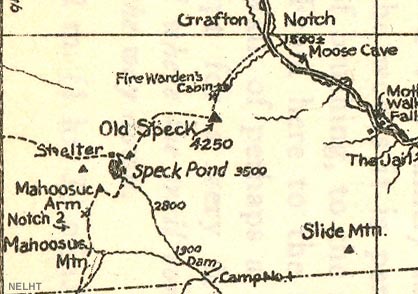
1931 AMC map of Old Speck
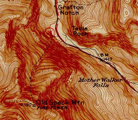
1945 USGS map of Old Speck
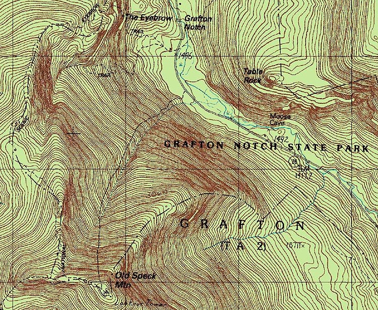
1984 USGS map of Old Speck
|
|
| Links: |
|
|
|
| Last updated 2011-08-25 |
| Disclaimer: Data provided for academic and historical purposes only. Respect all signs. |
|
|
