Jericho Trail
State: NH |
The Jericho Trail ascended Iron Mountain from the south. The upper portion of this trail became the present day view and mine spur.
|
|
| Jericho Trail Details |
|
| Also Known As: |
|
|
| Location: |
White Mountains |
|
| Peak: |
Iron Mountain |
|
| Opened: |
|
|
| Closed: |
1920s? |
|
| Reason Closed: |
|
|
| Guidebook Descriptions: |
|
1931 AMC White Mountain Guide
The Cliffs and Iron Mines
The old Jericho Trail, from Jinks Hill Road (Rocky Branch Trail) to the summit of Iron Mountain, has been abandoned, but its upper end, between the Cliff’s and Duck’s Head Trail, has been maintained by the J.T.C. as branch of the latter, giving access to the Cliffs from above. The view from the Cliffs is the finest thing on the mountain, and well repays the effort of reaching them. From the junction described under Duck’s Head Trail the old path is followed S. for about 10 min. to a branch (sign) which leads W. in a few rods to the Cliffs. Water will sometimes be found in a marshy place shortly before reaching the viewpoint.
The iron mines may be reached by following the old Jericho Trail past the branch to the Cliffs and down over the ledges to a point about ½ m. below Duck’s Head Trail. Thus far the old cairns can be picked up without much difficulty, but below the mines the trail is practically obliterated. |
|
| Images: |
|
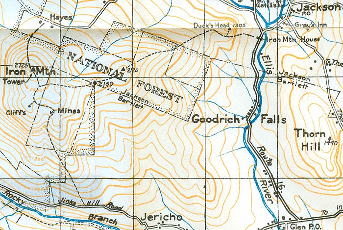
1940 AMC map of Iron Mountain
|
|
| Links: |
|
|
|
| Last updated 2011-09-06 |
| Disclaimer: Data provided for academic and historical purposes only. Respect all signs. |
|
|
