Tuttle Brook Trail
State: NH |
In conjunction with the upper Mt. Hale Trail, the Tuttle Brook Trail provided a route to Mt. Hale from the Twin Mountain area.
|
|
| Tuttle Brook Trail Details |
|
| Also Known As: |
|
|
| Location: |
White Mountains - Franconia |
|
| Peak: |
Mt. Hale |
|
| Opened: |
1930s? |
|
| Closed: |
Early 1960s |
|
| Reason Closed: |
|
|
| Guidebook Descriptions: |
|
1940 AMC White Mountain Guide
Tuttle Brook Trail (WMNF)
This trail follows to its end the road which passes the freight house of the now abandoned B. & M. RR station at Twin Mountain. Here the Baby Twins Trail diverges L, to the L (N) of the farm house. The Tuttle Brook Trail passes to the R (W) of the house. It crosses the Bethlehem pipe line 1 m. from the station and climbs by easy grades to the Hale Brook Trail ½ m. below the summit of Mt. Hale.
Distance. Station to Baby Twins Trail 0.6 m; to Mt. Hale 4 ½ m. (3 hrs.).
1948 AMC White Mountain Guide
Tuttle Brook Trail (WMNF)
This trail begins at the end of the road which passes the freight house of the now abandoned B. & M. RR station at Twin Mountain. Here the Sugarloaf Trail diverges L, to the L (N) of the Old Mill House (Burbank Place). The Tuttle Brook Trail passes to the R (W) of the house. It follows an old logging road and in a wet season is likely to be wet. It crosses the Bethlehem pipe line in 1 m. from the station and climbs by easy grades to the Mt. Hale Trail ½ m. below the summit of Mt. Hale.
Distance. Station to Sugarloaf Trail 0.6 m.; Mt. Hale 4.3 m. (3 hrs.).
1960 AMC White Mountain Guide
Tuttle Brook Trail (WMNF)
The Tuttle Brook Trail and the W end of the Sugarloaf Trail both begin at the picnic area at the end of a road (0.6 m.), which leaves US 3 at the former B&M RR station, now a barber shop, in Twin Mountain. The Sugarloaf Trail goes L along a cart road and in about 200 yds. bears R across the deeply gullied brook. The Tuttle Brook Trail heads S from the picnic area across the brook and up over the hill on an old logging road which is likely to be wet in a wet season. It crosses the Bethlehem pipe line at about 0.4 m. and climbs by easy grades until about 1 m. from the summit when it becomes somewhat steeper as it ascends a small NW shoulder. In a slight col 0.2 m. below the summit water may be obtained in a spring on a side trail L (E). In descending, at a point about 0.5 m. below the summit, bear R away from the abandoned Mt. Hale Trail.
Distance. Picnic area to summit of Mt. Hale 3.7 m. (2 hrs. 45 min.). |
|
| Images: |
|
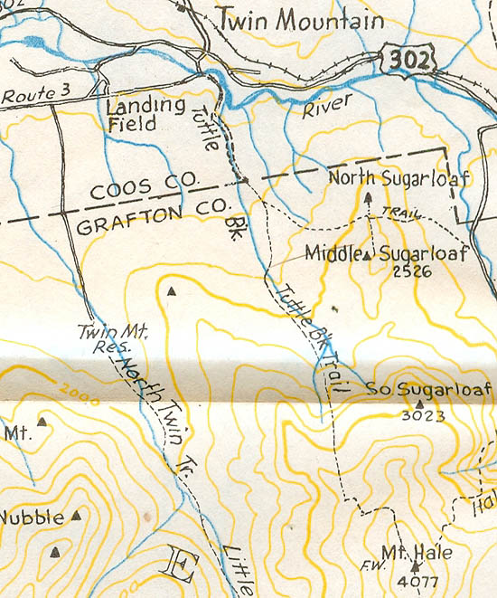
1960 AMC map of the Tuttle Brook Trail
|
|
| Links: |
|
|
|
| Last updated 2011-09-08 |
| Disclaimer: Data provided for academic and historical purposes only. Respect all signs. |
