Paugus Falls Path
State: NH |
A path to a long stretch of seasonal cascades once ran from the WODC path to Mt. Paugus.
|
|
| Paugus Falls Path Details |
|
| Also Known As: |
|
|
| Location: |
White Mountains - Sandwich |
|
| Peak: |
Mt. Paugus |
|
| Opened: |
Late 1890s? |
|
| Closed: |
Early 1900s? |
|
| Reason Closed: |
Logging, lack of use? |
|
| Guidebook Descriptions: |
|
1901 Guide to Wonalancet and the Sandwich Range of New Hampshire
Paugus Falls.
Paugus Falls, flowing over great, smooth ledges, but often dry in summer, may be reached by a trail – very indistinct in 1901 – which leaves the path right at the foot of the second steep ascent. From the falls a way out was “spotted” by Frank Bowles down the brook to the Bolles Trail about three miles from Nat. Berry’s on the Chocorua Mountain Road. The falls and trail are described in his book, “At the North of Bearcamp Water.”
|
|
| Images: |
|
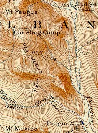
1931 USGS map of Mt. Paugus
|
|
| Links: |
|
| Paugus Brook Valley - Mountain Wandering |
|
| Last updated 2011-09-27 |
| Disclaimer: Data provided for academic and historical purposes only. Respect all signs. |
