Blue Trail
State: NH |
|
|
| Blue Trail Details |
|
| Also Known As: |
|
|
| Location: |
Lakes Region |
|
| Peak: |
Mt. Prospect |
|
| Opened: |
|
|
| Closed: |
|
|
| Reason Closed: |
|
|
| Guidebook Descriptions: |
|
1931 AMC White Mountain Guide
From North Holderness via Blue Trail
The first part of the Blue Trail is on Owl Brook Farm. It leaves the highway at a sign 200 ft. W. of the old Buzzel Huckins farm, now occupied by W.W. Colby, and follows an old range road through a young orchard and woods for ½ m. It then turns L. at the top of a sharp pitch, where the blue marks begin. ¼ m. beyond here the White Trail from Squam Lake enters from the R. The trail can be easily followed to the summit, and extends ¼ m. beyond to the Miser’s Cave. Water is found a short distance W. of the trail, midway between the summit and cave.
Distances. Highway to trail from Squam Lake ¾ m.; to summit 2 ¾ m.
1934 AMC White Mountain Guide
From North Holderness via Blue Trail
The first part of the Blue Trail is on Owl Brook Farm. It leaves the highway at a sign 200 ft. W. of the old Buzzel Huckins farm, now occupied by W.W. Colby, and follows an old range road through an orchard and woods for ½ m. It then turns L. at the top of a sharp pitch, where the blue marks begin. The trail can be easily followed to the summit, and extends ¼ m. beyond to Misers’ Cave. Water is found a short distance W. of the trail, midway between the summit and the cave. Distance. 2 ¾ m.
1948 AMC White Mountain Guide
From North Holderness via Blue Trail
This path is reached from the Holderness town meeting house-Plymouth road by turning R at the Carr School and continuing about 1 ¾ m. on the Perch Pond Road. The trail leaves the branch road, coming in on the L, near the top of the hill and follows an old range road through an orchard and woods for ½ m. It then bears L at the top of a sharp pitch, where the blue blazes commence, then through the woods to the open pasture just below the summit. Water is found a short distance W of the trail, midway between the summit and the Miser’s Cave ¼ m. beyond.
Distance 2 ¾ m. |
|
| Images: |
|
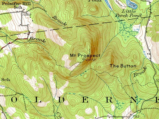
1928 USGS map of Mt. Prospect
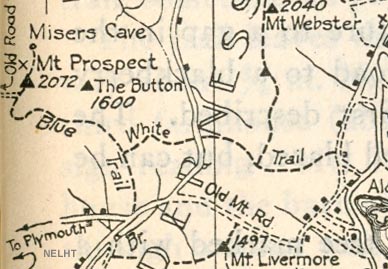
1931 AMC map of Mt. Prospect
|
|
| Links: |
|
|
|
| Last updated 2011-08-19 |
| Disclaimer: Data provided for academic and historical purposes only. Respect all signs. |
|
|
