Tecumseh Trail
State: NH |
The original hiking trail to Mt. Tecumseh from Waterville Valley follow the ridge north of Tecumseh Brook.
|
|
| Tecumseh Trail Details |
|
| Also Known As: |
|
|
| Location: |
White Mountains - Waterville |
|
| Peak: |
Mt. Tecumseh |
|
| Opened: |
1879 |
|
| Closed: |
|
|
| Reason Closed: |
|
|
| Guidebook Descriptions: |
|
1881 The White Mountains: A Handbook for Travelers
Mt. Tecumseh – A new and by far the best path to the summit, has been made by Appalachians sojourning at Waterville in 1879. It leaves the Osceola Path (see page 323) at the crossing of the W. Branch, 7/8 M. from Greeley’s, and makes nearly a straight line to the top, with a very steep grade on the upper part. 1 3/8 M. from Greeley’s a path diverges in 1/8 M. to a pretty cascade; and at 2 ¼ M. from Greeley’s is a delicious spring. The path is overshadowed by trees, except at a point 1/8 M. from the summit, whence a fine view is enjoyed. The entire length of the path is 3 1/16 M. It forms the easiest mountain excursion from Waterville, and the round trip has been made in half a day by ladies.
1892 Goodrich's The Waterville Valley
Tecumseh, N. 66° W. from House. 4008 ft.
Hotel to Osceola Bridge 4-5 M.; to Tecumseh Rapids, 1 ¼; to Spring, 2; to summit, 3 1-16.
This path is same as the Osceola path (p. 17) till Osceola Bridge is passed. Here we turn to left up the ridge. The climbing begins at once. The grade is quite heavy and increases steadily, the last mile being the hardest. The spring is a poor one. Tecumseh Rapids, on Tecumseh Brook, are reached by a short side path.
1931 AMC White Mountain Guide
Tecumseh Trail. (W.A.I.A.)
The trail leaves the Osceola Trail soon after the latter has crossed the West Branch, and follows a L. fork of the logging road to a camp. Here a R. fork of the road is taken, leading between the buildings and crossing Tecumseh Brook. The road makes a L. turn and the route follows the crest of the ridge. Arrows and cairns somewhat obscurely indicate the correct forks until the old trail is regained, at virgin forest, ¼ m. below summit. Water, not permanent, is found at about 2 m.
Distances. Waterville Inn to Tecumseh Trail, .9 m.; to summit about 3.1 m. (2 hrs. 30 min.).
1934 AMC White Mountain Guide
Tecumseh Trail. (W.A.I.A.)
The beginning of this trail is reached by taking either the Osceola Trail or the alternative route described above to the junction of trail and road here mentioned. From this junction follow the L. logging road across the West Branch to the new Waterville Gap Road (see below) and follow this to the R. The Tecumseh Trail diverges L. from this in a few yards (sign). It follows a logging road to an abandoned logging camp. Here the Mt. Tecumseh Ski Trail follows the logging road straight ahead, while the Tecumseh Trail takes the R. fork leading between the buildings, descends to and crosses Tecumseh Brook; then it makes a L. turn and follows the crest of the ridge until the old trail is regained at virgin forest, ¼ m. below the summit. Water, not permanent, is found at about 2 m.
Distances. Inn to Tecumseh Trail 0.9 m.; to summit 3.1 m. (2 hrs. 30 min.). |
|
| Images: |
|
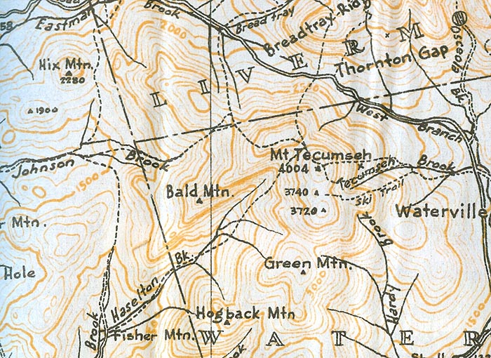
1940 AMC map of Mt. Tecumseh
|
|
| Links: |
|
|
|
| Last updated 2012-10-23 |
| Disclaimer: Data provided for academic and historical purposes only. Respect all signs. |
|
|
