Tunnel Ravine Trail
State: NH |
The Tunnel Ravine Trail provided a steep loop option in conjunction with the Benton Trail.
|
|
| Tunnel Ravine Trail Details |
|
| Also Known As: |
Tunnel Trail |
|
| Location: |
White Mountains - Moosilauke |
|
| Peak: |
Mt. Moosilauke |
|
| Opened: |
1930 |
|
| Closed: |
|
|
| Reason Closed: |
|
|
| Guidebook Descriptions: |
|
1931 AMC White Mountain Guide
Tunnel Ravine Trail. (D.O.C.)
This rough trail leaves the Benton Trail less than ¼ m. from the summit hut and descends rapidly by way of landslides and a brook ed to Tunnel Brook Road. There is a public shelter on the trail, near its lower end, accommodating 6.
1934 AMC White Mountain Guide
Tunnel Trail. (D.O.C.)
This picturesque, though steep and rough trail, also called Tunnel Ravine Trail, lies in a ravine S. of the ridge which bears the Benton Trail. As it is most used as a descent it will be so described. It leaves the Benton Trail 0.4 m. below the summit of Moosilauke. It soon reaches and descends a slide and then the brook at its foot, passing N. of a D.O.C. shelter. Shortly below the shelter it turns S. from the brook and follows a logging road to the abandoned Tunnel Brook Road. Following the latter N., Bungay Corner on the Kinsman Notch Road is reached in 4 ¼ m., or, turning S., Glencliff will be reached in about 7 m., the first 5 m. being rough and in places obstructed and obscure.
Distances. Summit to Tunnel Trail 0.4 m. (12 min.); to shelter 2 ¼ m. (2 hrs. 15 min.); to Tunnel Brook Road 3 m. (3 hrs.).
1940 AMC White Mountain Guide
Tunnel Ravine Trail (DOC)
[This trail has not been reopened since the hurricane, but is not considered “abandoned”, May 1, 1940.]
This picturesque, though steep and rough, trail lies in a ravine S of the ridge which bears the Benton Trail. As it is most used for descent it will be so described. It leaves the Benton Trail 0.4 m. below the summit of Moosilauke, soon reaches and descends bare ledges, marked with white paint, a slide, then the brook at its foot, passing N of a DOC shelter. Shortly below the shelter it turns S from the brook and follows a logging-road to the Tunnel Brook Trail. Following the latter N, Bungay Corner on the Kinsman Notch Road is reached in 4 ¼ m., or, turning S, Glencliff will be reached in about 5 ½ m.
Distances. Summit to Tunnel Trail 0.4 m. (12 min.); to shelter 2 ¼ m. (2 hrs. 15 min.); to Tunnel Brook Road 3 m. (3 hrs.).
1948 AMC White Mountain Guide
Tunnel Ravine Trail (DOC)
This picturesque, though steep and rough, trail lies in a ravine S. of the ridge which bears the Benton Trail. As it is most used for descent it will be so described. It leaves the Benton Trail 0.4 m. below the summit of Moosilauke, soon reaches and descends bare ledges marked with white paint, a slide, then the brook at its foot. Shortly it turns S from the brook and follows a logging-road to the Tunnel Brook Trail. Following the latter N, Bungay Corner on the Kinsman Notch Road is reached in 4 ¼ m., or, turning S, Glencliff will be reached in about 5 ½ m.
Distances. Summit to Tunnel Ravine Trail 0.4 m. (12 min.); Tunnel Brook Trail 3 m. (3 hrs.). |
|
| Images: |
|
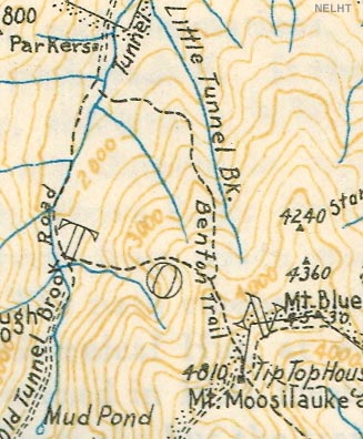
1934 AMC map of Mt. Moosilauke
|
|
| Links: |
|
|
|
| Last updated 2011-08-23 |
| Disclaimer: Data provided for academic and historical purposes only. Respect all signs. |
|
|
