Gale River Trail (southwest section)
State: NH |
The original Gale River Trail climbed the Garfield Ridge alongside Garfield Stream, passing by Hawthorne Fall on its way to the Garfield Ridge - Mt. Garfield col.
|
|
| Gale River Trail (southwest section) Details |
|
| Also Known As: |
|
|
| Location: |
White Mountains - Franconia |
|
| Peak: |
Mt. Garfield |
|
| Opened: |
1897? |
|
| Closed: |
|
|
| Reason Closed: |
Possibly due to land slide. The then-Galehead Trail would later be renamed Gale River Trail. |
|
| Guidebook Descriptions: |
|
1931 AMC White Mountain Guide
Gale River Trail. (W.M.N.F.)
This trail leaves the Daniel Webster Highway opposite the point where the road from Bethlehem Station enters from the N. This junction is known as “Five Corners” and is a few hundred yds. N.E. of Gale River Forest Camp. Lack of bridges makes the trail difficult in times of high water. At 7/10 m. the trail diverges L., leaving the telephone wires, at a sign marked “White Birch Camp.” Some distance further on the trail to White Birch Camp forks L.., whereas the F. S. trail keeps R. and soon crosses the North Branch of Gale River (no bridge). About 3 m. from the highway it recrosses the stream on a single stringer and, 200 yds. beyond, the Galehead Trail (see Section XIV) diverges L. (signs). The Gale River Trail again crosses the North Branch, bears uphill, and immediately crosses Garfield Stream diagonally. Beyond this point the road grows somewhat steeper and, after 1 m., passes near Hawthorne Fall, a beautiful cascade, reached by a short path to the R. (sign). The main trail soon crosses the stream twice and at length strikes the Garfield Ridge Trail in a clearing in the first col E. of Mt. Garfield and ¾ m. from the summit.
The watershed of the N. branch of Gale River, in which this trail lies, is part of the water supply of Littleton. Camping is forbidden, and trampers are cautioned not to pollute the streams.
Distances. From Daniel Webster Highway to the first crossing of Gale River 1 ¾ m. (50 min.); to Galehead Trail 3 m. (1 hr. 30 min.) to Hawthorne Fall 4 m. (2 hrs. 15 min.); to Garfield Ridge Trail 4.6 m. (2 hrs. 45 min.); to summit 5 3/8 m. (3 hrs. 30 min.). Returning, 2 ½ hrs.
1934 AMC White Mountain Guide
Gale River Trail. (W.M.N.F.)
This trail leaves the Daniel Webster Highway opposite the point where the road from Bethlehem Station enters from the N. This junction is known as “Five Corners” and is a few hundred yds. N.E. of Gale River Forest Camp. At 0.7 mi. the trail diverges L., leaving the telephone wires, at a sign “White Birch Camp.” Some distance further on a trail to this camp forks L., whereas the Gale River Trail keeps R. and soon crosses the N. Branch of Gale River (no bridge). About 3 m. from the highway it recrosses the stream and, 0.2 m. beyond, the Galehead Trail (see Section XIV) diverges L. (signs). The Gale River Trail again crosses the North Branch, bears up-hill, and immediately crosses diagonally. Beyond this point the road grows somewhat steeper and, after 1 m., passes near Hawthorne Fall, a beautiful cascade, reached by a short path to the R. (sign). The main trail soon crosses the stream twice and at length strikes the Garfield Ridge Trail in a clearing in the first col E. of Mt. Garfield and 0.9 m. from the summit.
While the route of the Gale River Trail is as described above, an alternate route is possible for about 1 m. of its lower part. At 0.7 m., instead of diverging L., keep R.; this route rejoins the Gale River Trail just after the latter crosses the N. branch for the first time.
The watershed of the N. branch of Gale River, in which this trail lies, is part of the water supply of Littleton. Camping is forbidden, and trampers are cautioned not to pollute the streams.
Distances. From Daniel Webster Highway to the first crossing of Gale River 1 ¾ m. (50 min.); to Galehead Trail 3 m. (1 hr. 30 min.) to Hawthorne Fall 4 m. (2 hrs. 15 min.); to Garfield Ridge Trail 4.6 m. (2 hrs. 45 min.); to summit 5 ½ m. (3 hrs. 50 min.). Returning, 2 ½ hrs.
1940 AMC White Mountain Guide
Gale River Trail (WMNF)
This trail leaves the Daniel Webster Highway (US 3) opposite the junction with the road from Bethlehem Junction. This locality, known as “Five Corners,” is a few hundred yds. NE of Gale River Forest Camp. At 0.7 m. the trail diverges L from the road leading to the Littleton Water Works (sign). At 1.5 m. the Nubble Mountain Trail diverges L, the Gale River Trail keeping R and soon crossing the N Branch of Gale River. About 3 m. from the highway it recrosses the stream and, 0.2 m. beyond, the Galehead Trail (see Sect. XIV) diverges L (signs). The Gale River Trail again crosses the North Branch, bears up-hill, and immediately crosses Garfield Stream diagonally. Beyond, the path grows somewhat steeper and, after about 1 m., passes near Hawthorne Fall, a beautiful cascade, reached by a short path to the R (sign). The main trail soon crosses the stream twice and at length strikes the Garfield Ridge Trail in a clearing in the first col E of Mt. Garfield, 0.9 m. from the summit.
The watershed of the N branch of Gale River, in which this trail lies, is part of the water supply of Littleton. Camping is forbidden, and tampers are cautioned not to pollute the streams.
Distances. From Highway to: first crossing of Gale River 1.7 m. (50 min.); Galehead Trail 3.3 m. (1 hr. 55 min.); Hawthorne Fall 4.6 m. (3 hrs.); Garfield Ridge Trail 5.2 m. (3 hrs. 35 min.); summit 6.1 m. (4 hrs. 30 min.).
1948 AMC White Mountain Guide
Gale River Trail (WMNF)
This trail leaves US 3 opposite the junction with the road from Bethlehem Junction. This locality, known as “Five Corners,” is a few hundred yds. NE of Gale River Forest Camp. At 0.7 m. the trail diverges L from the road leading to the Littleton Water Works (sign). At 1.5 m. the Nubble Mountain Trail diverges L, the Gale River Trail keeping R and soon crossing the N Branch of Gale River. About 3 m. from the highway it recrosses the stream and, 0.2 m. beyond, the Galehead Trail (see Sect. XIV) diverges L (signs). The Gale River Trail again crosses the North Branch, bears up-hill, and immediately crosses Garfield Stream diagonally. Beyond, the path grows somewhat steeper and, after about 1 m., passes near Hawthorne Fall, a beautiful cascade, reached by a short path to the R (sign). The main trail soon crosses the stream twice and at length strikes the Garfield Ridge Trail in a clearing in the first col E of Mt. Garfield, 0.9 m. from the summit.
The watershed of the N branch of Gale River, in which this trail lies, is part of the water supply of Littleton. Camping is forbidden, and tampers are cautioned not to pollute the streams.
Distances. From Highway to: first crossing of Gale River 1.7 m. (50 min.); Galehead Trail 3.3 m. (1 hr. 55 min.); Hawthorne Fall 4.6 m. (3 hrs.); Garfield Ridge Trail 5.2 m. (3 hrs. 35 min.); summit 6.1 m. (4 hrs. 30 min.). |
|
| Images: |
|
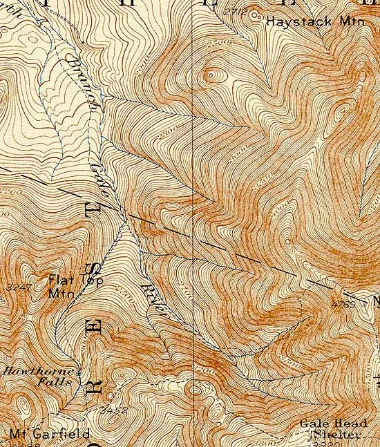
1932 USGS map of the Gale River Trail
|
|
| Links: |
|
|
|
| Last updated 2011-08-23 |
| Disclaimer: Data provided for academic and historical purposes only. Respect all signs. |
|
|
