Beech Hill Trail
State: NH |
|
|
| Beech Hill Trail Details |
|
| Also Known As: |
|
|
| Location: |
White Mountains - Kinsman |
|
| Peak: |
Beech Hill |
|
| Opened: |
|
|
| Closed: |
|
|
| Reason Closed: |
|
|
| Guidebook Descriptions: |
|
1934 AMC White Mountain Guide
Beech Hill Trail (W.M.N.F.), a Class 3 trail or “man-way,” is well cleared and, except for lack of signs at intermediate junctions, easy to follow. It leaves the Kinsman Notch Road (N.H. 112) 100 yds. W. of Clay Brook and 200 yds. E. of Wildwood Inn (sign). It runs N.E. across an overgrown pasture, follows an old wood-road to Black Brook and up the brook, which it crosses three times. The third crossing, 1 ½ m. from the highway, is marked only with blazes. Here the trail leaves the wood-road, turns generally N.W. and soon ascends Beech Hill steeply through a dense growth of small spruce, and, on a more level grade, by an old wood-road. About 1 m. from the brook it turns more to the N. and passes through the ruins of a camp. It then descends in a straight line on the N.W. slope of Beech Hill to the Eastman-Kinsman Ridge Trail, which it meets (sign) 100 yds. S.E. of a house on the L. bank of Reel Brook and about 7/8 m. from the highway (N.H. 112).
Distance. 3 ½ m. (2 hrs.).
1948 AMC White Mountain Guide
Beech Hill Trail (WMNF)
This trail leaves NH 112 100 yds. W of Clay Brook and about midway between Wildwood Inn and Wildwood Forest Camp. It runs NE across an overgrown pasture, follows an old wood-road to Black Brook and up the brook, which it crosses about 1 ½ m. from the highway. Here the trail leaves the wood-road, turns generally NW and soon ascends Beech Hill steeply through a dense growth of small spruce, and levels out on an old wood-road. About 1 m. from the brook it turns more N and passes through the ruins of a camp. It then descends in a straight line on the NW slope of Beech Hill to the Bog Pond Trail, which it meets 0.8 m. E of Schoolhouse No. 3 on NH 116. Distance 4.1 m. (2hrs. 15 mins.).
1976 AMC White Mountain Guide
Beech Hill Trail (WMNF)
This trail leaves NH 112 100 yds. W of Clay Brook and about midway between Wildwood Inn and Wildwood Campground. It runs NE across an overgrown pasture, follows an old wood-road to Black Brook and up to the brook, which it crosses about 1 ½ m. from the highway. Here the trail leaves the wood-road, turns generally NW and soon ascends Beech Hill steeply through a dense growth of small spruce, and levels out on an old wood-road. About 1 m. from the brook it turns more N and passes through the ruins of a camp. It then descends in a straight line on the NW slope of Beech Hill and ends at the Reel Brook Trail at a point 0.8 m. from NH 116.
Distance: 4.1 M. (2 hrs 15 min.). |
|
| Images: |
|
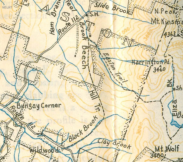
1934 AMC map of the Beech Hill Trail
|
|
| Links: |
|
|
|
| Last updated 2011-08-19 |
| Disclaimer: Data provided for academic and historical purposes only. Respect all signs. |
|
|
