Maskoma Trail
State: NH |
The Maskoma Trail, running about 20 miles from Mt. Cardigan to Smarts Mountain, was opened in 1937 by Clyde Smith Sr. and the AMC. By 1960, only segments of the trail existed. The last portion of the trail, up Smarts Mountain, likely closed sometime between the late 1980s and early 1990s.
|
|
| Maskoma Trail Details |
|
| Also Known As: |
Mascoma Trail |
|
| Location: |
Western New Hampshire |
|
| Peak: |
Mt. Cardigan |
|
| Opened: |
1937 |
|
| Closed: |
1980s or 1990s |
|
| Reason Closed: |
Lack of use and maintenance |
|
| Guidebook Descriptions: |
|
1940 AMC White Mountain Guide
Maskoma Trail
This 20 m. route, opened in 1937, connects Mt. Cardigan with Cummins Pond and Smarts Mtn., linking the Cardigan area with the DOC trails and the through Appalachian Trail.
From the Mowglis Trail and junction of Orange Cove Trail the Maskoma trail climbs the S side of Cataloochee Mtn. (2,564 ft.) then makes a long gradual descent NW through forest and across pasture and open field to the tumble-down buildings of the Farr place. This point, about 1 m. E of Mt. Tug, may be reached from Orange by car to the Eastman farm, and thence by old road about 1 ¼ m. Beyond the Farr place, the trail continues on gently descending old road, past a deserted house, crosses the S Branch of Baker River, then rises steeply through beautiful forest to the abandoned Keyes mica mine. Here are the old engine and buildings, one of which is usable as a camp. From the nearby dump is a fine view toward Cardigan.
Bearing L at the mine, the plainly marked trail leads through forest to Derby, then Bryant Pond (1 ½ m.), two wilderness beauty spots. (A shelter will be built at Derby Pond in 1940). The trail then crosses Kimball Peak (2,340 ft.) and Grassy Knob beyond which it descends to the Canaan-Dorchester highway to Elkins Hill.
It follows the highway N ¼ m., enters a woods road near an abandoned school house and passes near Paul Smith’s. Take R fork up the grade, through open fields, bearing L over Thompson Hill (2,380 ft.) from which are good views, then descending through logged section past shelter (water) to the 4-corners. The trail soon crosses Parker Young tractor road, and leads to the Lime-Dorchester highway near Cummins Pond which is followed W around the S end to Mascoma Lodge, a girl’s summer camp.
Smarts (or Mascoma) Mtn. is in fully view from the Lodge. Alternative routes, plainly marked, soon merge with the main trail which rises steadily through forest 5 m. to the higher (W) summit, where it joins the Appalachian Trail, beneath the 40 ft. steel fire lookout tower.
Distances. Mowglis Trail, to Maskoma Trail Jct., 2.1 m., to Farr Place, 3.7 m., Derby Pond, 5 m., Dorchester Road, 7.6 m. Section W of road to be measured in 1940.
1948 AMC White Mountain Guide
Maskoma Trail
This long route, also called Smarts Trail no. 3 (supra), connects Mt. Cardigan with Cummins Pond and Smarts Mt., linking the Cardigan area with the DOC trails and the Appalachian Trail.
From the junction of the Mowglis Trail and the Orange Cove Trail the Maskoma Trail climbs the S side of Cataloochue Mt. (2,564 ft.) then makes a long gradual descent NW through forest and across pasture and open field to the tumble-down buildings of the Farr place. Lumbering operations between Cataloochee Mt. and the Farr place were being conducted in 1945. This point, about 1 m. E of Mt. Tug, may be reached from Orange by car to the Eastman farm, and thence by old road about 1 ¼ m. Beyond the Farr place, the trail continues gently descending old road, past a deserted house, crosses the S Branch of Baker River, then rises steeply through beautiful forest to the abandoned Keyes mica mine. Here are the old engine and buildings, one of which is usable as a camp. From the nearby dump is a fine view toward Cardigan.
Bearing L at the mine, the plainly marked trail leads through forest to a shelter at Derby Pond, and then Bryant Pond (1 ½ m.), two wilderness beauty spots. The trail then crosses Kimball peak (2,340 ft.) and Grassy Knob beyond which it descends to the Canaan-Dorchester highway at Elkins Hill.
It follows the highway N ¼ m., enters a woods road near an abandoned school house for ¼ m., and passes near Paul Smith’s. Take R fork up the grade, through open fields, bearing L over Thompson Hill (2,380 ft.) from which are good views, then descending through logged section past log shelter (water) 4 m. from Paul Smith’s to the 4-corners. The trail soon crosses the Parker Young tractor road, and leads to the Lyme-Dorchester highway near Cummins Pond which is followed W around the S end of Maskoma Lodge, a grils’ summer camp.
Smarts (or Maskoma) Mt. is in full view from the Lodge. Alternative routes, plainly marked, over 1 ½ m. of old country road to Clough Place where trails merge with the main trail which rises steadily through forest 2 ½ m. to the higher (W) summit, where it joins the Appalachian Trail, beneath the 40 ft. steel fire lookout tower.
Distances. Cardigan via Mowglis Trail to Maskoma Trail Jct. 2.1 m.; Farr Place 3.7 m.; Derby Pond 5 m.; Dorchester Road 7.6 m.; Smarts Mt. 11.75 m.
1960 AMC White Mountain Guide
[Mowglis Trail]
Thence the route follows the old road S following Atwell Brook about 3 ½ m. mostly steady upgrade to the height-of-land. Here is the junction with the Maskoma Trail (R) and the Orange Cove Trail.
1963 AMC White Mountain Guide
[Mowglis Trail]
Thence the route follows the old road S following Atwell Brook about 3 ½ m. mostly steady upgrade to the height-of-land. Here is the junction with the old Maskoma Trail (R) to Smarts Mtn. (now passable only to Cataloochee Mt.) and the Orange Cove Trail.
1966 AMC White Mountain Guide
[Mowglis Trail]
Thence the route follows the old road S following Atwell Brook about 3 ½ m. mostly steady upgrade to the height-of-land. Here is the junction with the Orange Cove Trail (the old Mascoma Trail, which formerly left (R) this point, going over Cataloochee Motn., and continuing NW to Smarts Mtn, on the Appalachian Trail, was abandoned, and was impassable in 1965).
|
|
| Images: |
|
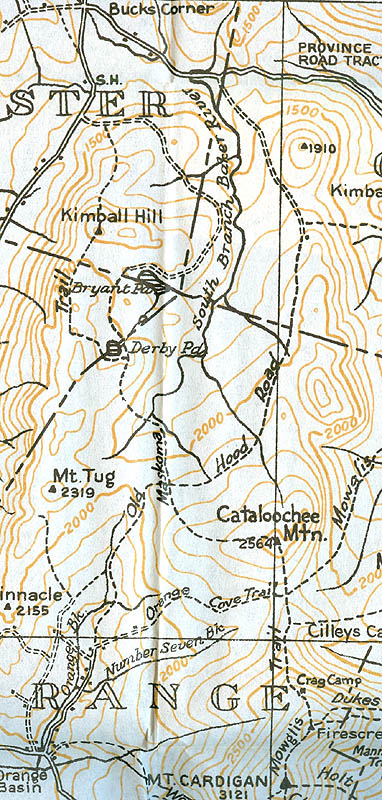
1940 AMC map of Mt. Cardigan
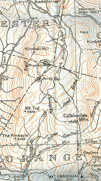
1948 AMC map of Mt. Cardigan
|
|
| Links: |
|
|
|
| Last updated 2011-08-24 |
| Disclaimer: Data provided for academic and historical purposes only. Respect all signs. |
|
|
