Gorge Brook Slide Trail
State: NH |
The Gorge Brook Slide Trail climbed from near the "last known water" on the Gorge Brook Trail to the Moosilauke Carriage Road.
|
|
| Gorge Brook Slide Trail Details |
|
| Also Known As: |
Moosilauke Slide Trail |
|
| Location: |
White Mountains - Moosilauke |
|
| Peak: |
Mt. Moosilauke |
|
| Opened: |
Late 1960s |
|
| Closed: |
Late 1970s |
|
| Reason Closed: |
|
|
| Guidebook Descriptions: |
|
1976 AMC White Mountain Guide
Gorge Brook Slide Trail (DOC)
This is a link between the Gorge Brook Trail and the Carriage Road.
This trail follows a recent slide, which affords more of a challenge than most trails in the area, because of its steep and rocky terrain.
It leaves the Gorge Brook Trail at 1.3 m. from the Ravine Lodge, and immediately begins its steep ascent up the slide reaching the top of slide at 0.3 m., then passing through an area of stunted pines to the Carriage Rd. at 0.7 m. turn R on Carriage Rd. passing junction of Glencliff Trail in 0.3 m. and main summit 0.9 m. beyond.
Distances: Ravine Lodge (now closed) to junction of Gorge Brook Slide Trail 1.3m.; Carriage Road 2 m.; summit 3.2 m. (2 ¼ hrs.). |
|
| Images: |
|
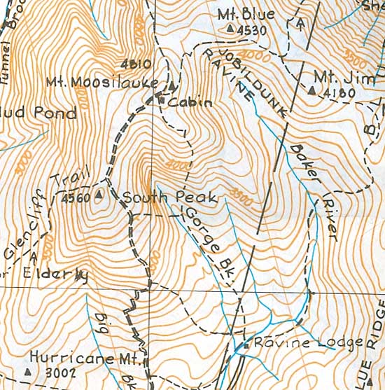
1976 AMC map of Mt. Moosilauke
|
|
| Links: |
|
|
|
| Last updated 2011-08-26 |
| Disclaimer: Data provided for academic and historical purposes only. Respect all signs. |
