Doublehead Trail
State: NH |
The Doublehead Trail ascended South Doublehead from the southeast.
|
|
| Doublehead Trail Details |
|
| Also Known As: |
|
|
| Location: |
White Mountains - East |
|
| Peak: |
South Doublehead |
|
| Opened: |
|
|
| Closed: |
1950s? |
|
| Reason Closed: |
|
|
| Guidebook Descriptions: |
|
1931 AMC White Mountain Guide
Doublehead Trail. (U.S.F.S.)
This path ascends the S. peak from the East Branch on the S.E. It is an excellent trail in its lower portion, but near its upper end it lies for a considerable distance over loose rocks, with treacherous footing. It leaves the East Branch trail 1 m. from Panno’s on relocation about the first crossing, some 100 yds. upstream from the ruined trestle. It follows the marshy W. bank of the river 1/8 m. and then bears N.W. following a small brook for about 10 min. (last water). It slabs up the S. peak, through a fine growth of hardwood, and finally comes into the Old Trail a few steps below its terminus on the W. ledges. The U.S.F.S. sign at the junction is poorly placed and does not accurately indicate the trail. Persons descending will find its beginning on the E. side of the Old Trail, a few steps above the U.S.F.S. sign.
Distances. Panno’s to Doublehead Trail, 1 m. (30 min.); to S. peak 2 ¾ m. (2 hrs. 15 min.).
1934 AMC White Mountain Guide
Doublehead Trail. (W.M.N.F.)
This path ascends the S. peak from the East Branch, on the S.E. It is an excellent trail in its lower portion, but near its upper end it lies for a considerable distance over loose rocks, with treacherous footing. It diverges L. from the East Branch Trail just before it crosses the foot-bridge over the East Branch River and ascends the steep W. bank. At the top of the bank it turns R. into an old logging-road, which it follows N. for 0.4 m. It then leaves the road and bears N.W., following a small brook for about 10 min. (last water), slabs up the S. peak, through a fine growth of hardwood, and finally comes into the Old Trail a few steps below its terminus on the W. ledges. Persons descending will find its beginning on the E. side of the Old Trail, a few steps below the summit ledges.
Distances. Panno’s to Doublehead Trail, 0.9 m. (30 min.); to S. peak 2.6 m. (2 hrs. 15 min.).
1940 AMC White Mountain Guide
Doublehead Trail (WMNF)
This path ascends the S peak from the East Branch, on the SE. Excellent in its lower portion, near its upper end it lies over loose rocks, with treacherous footing. It diverges L from the East Branch Trail just before it crosses the foot-bridge over the East Branch and ascends the steep W bank. At the top it turns R into an old logging-road, which it follows N for 0.4 m. It leaves the road and bears NW, following a small brook for about 10 min. (last water), slabs up the S peak through a fine growth of hardwood, and comes into the trail cross the S peak humps just as it begins to descend the col. Descending, its beginning is on the E side of the trail across the S peak a few steps below the ledge nearest the col.
Distances. Panno’s to Doublehead Trail, 0.9 m. (30 min.); to S peak 2.6 m. (2 hrs. 15 min.).
1948 AMC White Mountain Guide
Doublehead Trail (WMNF)
This trail ascends the easterly side of the S peak. It diverges L from the East Branch Trail just before the latter crosses the East Branch. It climbs the steep W bank, turns R and follows an old logging road N for 0.4 m. Bearing L (NW) away from the road it follows a small brook bed for a short distance (last water), continues on through a fine growth of hardwood, slabs up the S peak, becomes steeper in its upper portion, and comes into the trail across the summit just before it descends into the col. Turn L for the ledges. Descending, its beginning is on the E side of the trail across the S peak a few steps from the ledge nearest the col.
Distances. Panno’s to Doublehead Trail, 0.9 m. (30 min.); S peak 2.6 m. (2 hrs. 15 min.). |
|
| Images: |
|
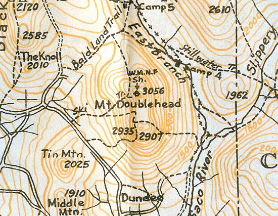
1940 AMC map of Doublehead
|
|
| Links: |
|
|
|
| Last updated 2011-09-13 |
| Disclaimer: Data provided for academic and historical purposes only. Respect all signs. |
|
|
