Russell Crag Trail
State: NH |
The Russell Crag Trail once provided a short view-based hike near Lincoln.
|
|
| Russell Crag Trail Details |
|
| Also Known As: |
|
|
| Location: |
White Mountains |
|
| Peak: |
Russell Crag |
|
| Opened: |
|
|
| Closed: |
1950s? |
|
| Reason Closed: |
|
|
| Guidebook Descriptions: |
|
1931 AMC White Mountain Guide
Russell Crag. (N.W.I.A. Trail)
The summit of Russell Mountain (2,445 ft.), S. of Loon Pond, is much overgrown and has few outlooks, but Russell Crag (1,640 ft.), a shoulder to the S., offers fine views.
The path leaves the highway down the E. side of the Pemigewasset River just beyond the fork before descending the hill to the Mountain Park Hotel. Take the L. branch of the road through a gate and across a small bridge. Turn L. into the field, and follow its N. edge near a brook until it reaches an old logging road at a small hemlock tree (sign). It ascends this road through the woods in an E. and then S. direction to the top of the ridge. From there a line of blazes will be seen on the R., which leads to the summit and then continues S. along the ledges to the best view-points. The southernmost ledge gives an outlook into Thornton Gore.
Distance. From highway to summit ¾ m. (30 min.).
1934 AMC White Mountain Guide
Russell Crag
This crag (1,640 ft.), a S shoulder of Russell Mt., offers fine views. A trail (N.W.I.A.) leaves the highway on the E. side of the Pemigewasset River at the top of the hill N. of the Mountain Park Hotel. Take the E. branch of the road through a gate and across a small bridge. Turn L. into the field, and follow its N. edge near a brook until it reaches an old logging road at a small hemlock tree (sign). It ascends this road through the woods in an E. and then S. direction to the top of the ridge. From there a line of blazes will be seen on the R., which leads to the summit and then continues S. along the ledges to the best viewpoints.
Distance. From highway to summit ¾ m. (30 min.).
1940 AMC White Mountain Guide
Russell Crag (1,640 ft.) (NWIA)
This is a S shoulder of Russell Mt., and offers fine views. The trail leaves the highway on the E. side of the Pemigewasset River at the top of the hill N of the Mountain Park Hotel. Take the E branch of the road through a gate and across a small bridge. Turn L. beside a flower garden into the field, and follow its N edge near a brook until it reaches an old logging road at a small hemlock tree (sign). It ascends this road through the woods E and then S nearly to the top of the ridge, whence a line of blazes on the R leads to the summit; then continues S along the ledges to the best view-points. The S ledge gives an outlook into Thornton Gore.
Distance. From highway to summit ¾ m. (30 min.).
1948 AMC White Mountain Guide
Russell Crag (1,640 ft.) (NWIA)
This is a S shoulder of Russell Mt., and offers fine views. The trail leaves the East Side Road at the top of the hill N of the Mountain Park Hotel. Take the E branch of the road across a small bridge. Turn L. beside a flower garden into the field, and follow its N edge near a brook until it reaches an old logging road at a small hemlock tree (sign). It ascends this road through the woods E and then S nearly to the top of the ridge, whence a line of blazes on the R leads to the summit; then continues S along the ledges to the best view-points. The S ledge gives an outlook into Thornton Gore.
Distance. From highway to summit ¾ m. (30 min.). |
|
| Images: |
|

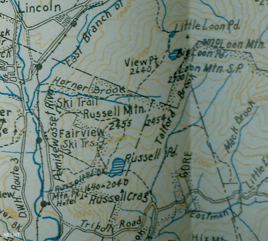
1934 AMC map of Russell Crag
|
|
| Links: |
|
|
|
| Last updated 2011-08-30 |
| Disclaimer: Data provided for academic and historical purposes only. Respect all signs. |
|
|

