Duck's Head Trail
State: NH |
The Duck's Head Trail ascended Duck's Head from Jackson, then continued over Green Hill to Iron Mountain.
|
|
| Duck's Head Trail Details |
|
| Also Known As: |
|
|
| Location: |
White Mountains - Montalban |
|
| Peak: |
Iron Mountain |
|
| Opened: |
1905 |
|
| Closed: |
1950s? |
|
| Reason Closed: |
|
|
| Guidebook Descriptions: |
|
1931 AMC White Mountain Guide
Duck’s Head Trail. (J.T.C.)
This trail was built in 1905 by W.A. Meserve of Jackson. It starts at the automobile sheds of the Iron Mountain House and is clearly marked by signs and cairns to the upper L. corner of the pasture, where it crosses a little ferny dell and enters the woods, winding about under the ledges to within about 150 yds. of the top of Duck’s Head. Here it divides, the L. branch going to Iron Mountain and the R. to the top of Duck’s Head. The latter affords a fine view of the valleys to the S. and E. Continuing toward Iron Mountain, the path passes alternately through wooded gullies and over ledgy ridges, affording extensive views to the N., S. and E., and finally ascends the rocky shoulder which leads W. and then N. to the summit. On the ridge, considerably below the top, the path to the Cliffs leaves on the L., marked by a sign. Water is sometimes found in a ravine about 10 min. beyond Duck’s Head, but it will fail in dry seasons. In wet seasons water can usually be found in pools on the ledges.
Distances. Iron Mountain House to Duck’s Head branch ½ m. (30 min.); to water (unreliable) 3/4 m.; to first summit 2 m. (1 hr. 45 min.); to Jericho Path 3 m. (2 hrs. 30 min.); to main summit 3 1/3 m. (3 hrs.).
1934 AMC White Mountain Guide
Duck’s Head Trail. (J.T.C.)
This trail starts at the automobile sheds of the Iron Mountain House and is clearly marked by signs and cairns to the upper L. corner of the pasture, where it crosses a little ferny dell and enters the woods, winding about under the ledges to within about 150 yds. of the top of Duck’s Head. The latter is reached in about 1/8 m. by a branch trail leading to the R. and offers good views to the S. and E. Continuing toward Iron Mountain, the path passes alternately through wooded gullies and over ledgy ridges, affording extensive views to the N., S. and E., and finally ascends the rocky shoulder which leads W. and then N. to the summit. On the ridge, considerably below the top, the path to the Cliffs and Jericho leaves on the L., marked by a sign. There is no reliable water on this trail.
Distances. Iron Mountain House to Duck’s Head branch ½ m. (30 min.); to first summit 2 m. (1 hr. 30 min.); to Jericho path 3 m. (2 hrs. 15 min.); to main summit 3 1/8 m. (2 hrs. 40 min.).
1940 AMC White Mountain Guide
Duck’s Head Trail (JSOC)
This trail starts at the automobile sheds of the Iron Mountain House and is marked by signs and cairns to the upper L corner of the pasture, where it crosses a little ferny dell and enters the woods, winding about under the ledges to within 150 yds. of the top of Duck’s Head, reached in about 1/8 m. by a branch trail leading R. It offers good views to the S and E. The main path then passes alternately through wooded gullies and over ledgy ridges, affording extensive views to the N, S and E, and finally ascends the rocky shoulder which leads W and then N to the summit. On the ridge, below the top, the path to the Cliffs and Jericho leaves on the L, marked by a sign. There is no reliable water on this trail.
Distances. Iron Mtn. House to: Duck’s Head branch ½ m. (30 min.); first summit 2 m. (1 hr. 30 min.); Jericho Path 3 m. (2 hrs. 15 min.); main summit 3 1/3 m. (2 hrs. 40 min.).
1948 AMC White Mountain Guide
Duck’s Head Trail (JSOC)
This trail starts at the south end of the Iron Mountain House and is marked by signs and cairns to the upper L corner of the pasture, where it crosses a little ferny dell and enters the woods, winding about under the ledges until about 150 yds. from the top of Duck’s Head, reached in about 1/8 m. by a branch trail leading R. This point offers good views to the S and E. The main path then passes alternately through wooded gullies and overly ledgy ridges, affording extensive views to the N, S and E, and finally ascends to the rocky shoulder which leads W and then N to the summit and the tower. On the ridge, below the top, the path to the Cliffs and Jericho leaves on the L, marked by a sign. There is no reliable water on this trail.
Distances. Iron Mtn. House to Duck’s Head branch ½ m. (30 min.); first summit 2 m. (1 hr. 30 min.); Jericho Path 3 m. (2 hrs. 15 min.); main summit 3 1/3 m. (2 hrs. 40 min.). |
|
| Images: |
|
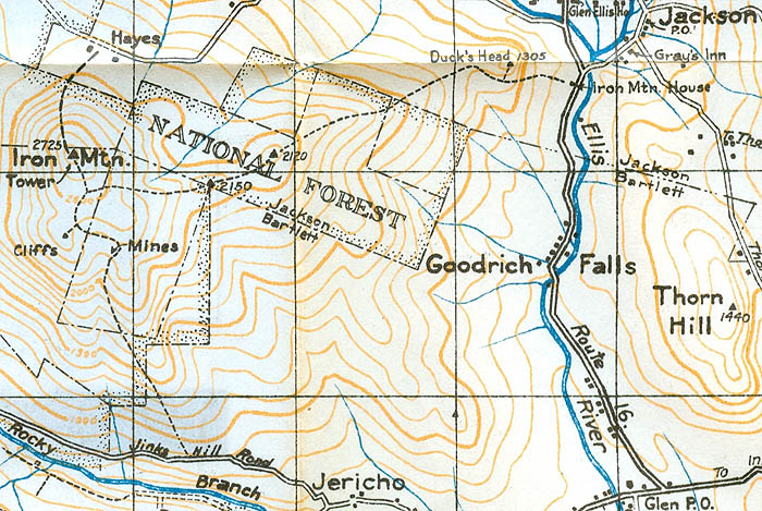
1940 AMC map of Iron Mountain
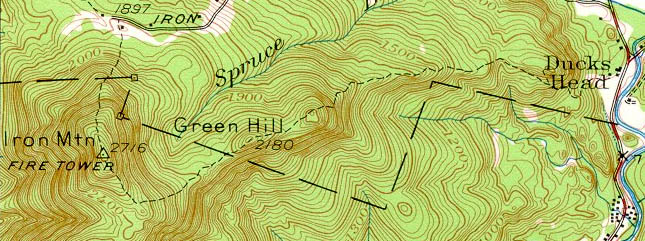
1942 USGS map of Iron Mountain
|
|
| Links: |
|
|
|
| Last updated 2011-09-06 |
| Disclaimer: Data provided for academic and historical purposes only. Respect all signs. |
|
|
