Nubble Mountain Trail
State: NH |
The Nubble Mountain Trail looped over Nubble Mountain/Haystack Mountain, from Gale River Road to US 3.
|
|
| Nubble Mountain Trail Details |
|
| Also Known As: |
|
|
| Location: |
White Mountains - Franconia |
|
| Peak: |
Nubble Mountain |
|
| Opened: |
Late 1930s |
|
| Closed: |
Early 1960s |
|
| Reason Closed: |
|
|
| Guidebook Descriptions: |
|
1940 AMC White Mountain Guide
Nubble Mountain Trail (WMNF)
This trail runs SE from the Daniel Webster Highway 0.3 m. SW of the WMNF boundary at Seymour’s “Last Chance” cabins and runs to the Gale River Trail 1 ½ m. from Five Corners. At 2.05 m. a side trail L leads in ¼ m. to the ledgy summit of the Nubble.
Distance. Highway to Nubble 2.3 m. (2 hrs. 45 min.); to Gale River Trail 4.15 m. (4 hrs. 45 min.).
1948 AMC White Mountain Guide
Nubble Mountain Trail (WMNF)
This trail elaves US 3 at a point 0.3 m. SW of the WMNF boundary at the “Last Chance Filling Station.” It shortly crosses a brook, heads generally SE through the woods and after about 1 ½ m. begins to ascend the N slope of Nubble Mtn. In another ½ m. a branch trail leaves L (SE) and reaches the ledgy summit of the Nubble in about ¼ m. The main trail turns sharp R (W) and begins to descend, crosses a brook at the foot of a bare rocky slope, then ascends and crosses the Nubble Brook-Gale River divide and, bearing more W, continues on down toward Gale River. About 1 m. beyond the divide the trail crosses a brook, passes White Birch Camp (R), then crosses another brook, and after a short distance ends at the Gale River Trail at a point about 1 ½ m. from Five Corners.
Distances. US 3 to Nubble 2.3 m. (2 hrs.); Gale River Trail 4.3 m. (4 hrs.).
1960 AMC White Mountain Guide
Nubble Mountain Trail (WMNF)
This trail leaves the end of a straight section of the former US 3 at a point 0.3 m. SW of the “Last Chance Filling Station.” It shortly crosses a brook, heads generally SE through the woods and after about 1 ½ m. begins to ascend the N slope of the Nubble. In another ½ m. a branch trail leaves L (SE) and reaches the ledgy summit of the Nubble in about ¼ m. The main trail turns sharp R (W) and begins to descend, crosses a brook at the foot of a bare rocky slope, then ascends and crosses the Nubble Brook-Gale River divide and, bearing more W, continues on down toward Gale River. About 1 m. beyond the divide the trail crosses a brook, passes the site of White Birch Camp (R), then crosses another brook, and ends at the Gale River Trail at a point 1.8 m. from Five Corners.
Distances. US 3 to Nubble 2.3 m. (1 hr. 40 min.); Gale River Trail 3.7 m. (2 hrs. 30 min.); Five Corners 5.5 m. (3 hrs. 35 min.). |
|
| Images: |
|
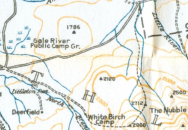
1940 AMC map of Nubble Mountain
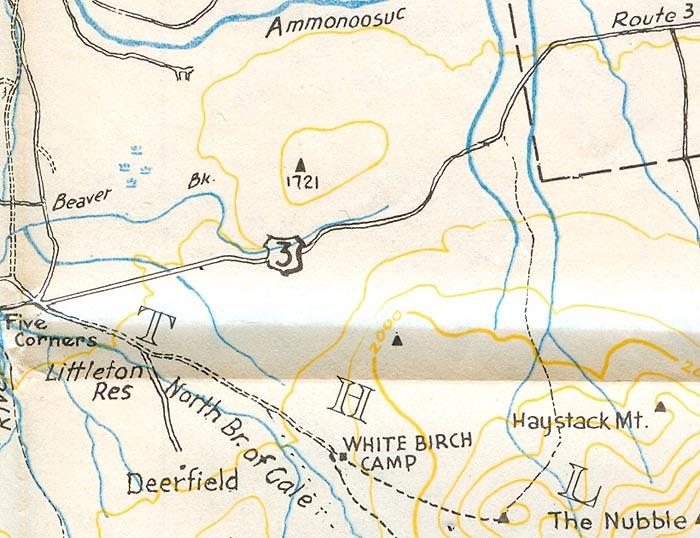
1960 AMC map of Nubble Mountain
|
|
| Links: |
|
|
|
| Last updated 2011-09-13 |
| Disclaimer: Data provided for academic and historical purposes only. Respect all signs. |
|
|
