Osseo Trail
State: NH |
The former Osseo Trail, originally called the Franconia Ridge Trail, climbed from near the present day Loon Mountain main entrance to Mt. Flume. The present day Osseo Trail was opened to replace the original Osseo Trail when the Clear Brook Condominiums were constructed.
|
|
| Osseo Trail Details |
|
| Also Known As: |
Franconia Ridge Trail |
|
| Location: |
White Mountains - Franconia |
|
| Peak: |
Mt. Flume |
|
| Opened: |
1905 |
|
| Closed: |
1983 |
|
| Reason Closed: |
Construction of condominiums at bottom of trail |
|
| Guidebook Descriptions: |
|
1931 AMC White Mountain Guide
Franconia Ridge Trail. (East Branch Valley to Mt. Liberty.) (A.M.C.)
This trail starts on the line of the logging railroad in the East Branch Valley and ends at the summit of Mt. Lafayette. It is joined S. of Mt. Flume by the Flume Slide Trail, N. of Mt. Liberty by the Liberty Spring Trail, on which is situated Liberty Spring Shelter, a convenient over-night stopping-place for those essaying the entire ridge, which, except for the strongest trampers, requires two days. Liberty Spring (3/8 m. below the Ridge Trail) is the only sure water above Clear Brook (below Osseo Peak). Those wishing to do the higher part of the range in one day are advised to start from the Flume.
The trail is reached by following the logging railroad 2 ¾ m. E. from Lincoln, as described above, to Camp 3 at the upper dam. It starts at a sign N.of the railroad, near the camp, and soon turns into an old logging road which bears sharply to the L. It then curves gradually to the R. until the general directions is N. with good surface and easy grades. In 10 min. it crosses Clear Brook, and in 20 min. more reaches a ruined camp and the second crossing of Clear Brook. For 5 min. more the road follows the brook, rising a little above it (last sure water), then turns sharply to the R. into a branch road (wet going), bears to the L. and soon enters hardwood growth.
The trail now zigzags with increasing steepness in a N.E. direction for about ½ hr., then climbs into an easy old road leading to the R. for ¼ hr. It then ascends over steep ledges and through small growth to another road, which passes through the lowest point in the ridge between Osseo Peak and Potash Knob, its southern shoulder. On the ridge a huge overhanging rock at the L., where a camp formerly existed, affords good shelter. Immediately beyond, the trail turns sharply to the L. and ascends more rapidly on a logging road for 5 min., then climbs to the R. to a still higher, parallel road. At the end of this road it ascends steeply to the R. around a shoulder and gains, in a few minutes, a little shelf at the base of an apparently inaccessible ledge. A stationary ladder leads up to the L. over this ledge, whence the trail slabs for 5 min. the steep S. side of the peak. It then turns sharply to the L. up a little ravine, and after a short, stiff climb gains the ridge which, followed 5 min., leads to the summit of Osseo (3,640 ft.). Just as the trail gains the ridge a short side-path leads to the L. to the edge of a cliff from which there are good views. To the E. the peak is wooded, with few outlooks.
Resuming, the main trail meanders for ¼ hr. in thick growth, then takes a straight line N. over the ridge, which leads in ½ hr. of gradual ascent to the junction with another ridge running W. and connecting with the Coolidge Mountains. Continuing N., the trail descends a little, bears to the L. for a few minutes and follows the part of the ridge leading straight toward Flume Mountain, glimpses of which are caught through the trees.
The last ¼ hr. before reaching the summit of Flume Mountain (4,327 ft.) is relatively steep, and just after passing the junction with the Flume Slide Trail (supra) the path climbs the knife-edge of the serrated peak, emerging finally on an area but a few yards square, which forms the summit. The peak overlooks on one side the wonderful natural theater of the Flume and Liberty slides of 1883, and on the other valley between the Franconia and Twin Ranges, with Mt. Liberty beyond the saddle-like intervening ridge.
Distances. Lincoln to Camp 3, 2 ¾ m. (1 hr.); to Osseo Peak 6 m. (3 hrs. 45 min.); to Flume Mountain 8 ½ m. (5 hrs. 15 min.) |
|
| Images: |
|
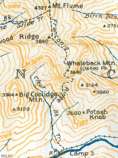
1940 AMC map of Mt. Flume
|
|
| Links: |
|
|
|
| Last updated 2011-09-20 |
| Disclaimer: Data provided for academic and historical purposes only. Respect all signs. |
|
|
