Gleason Trail
State: NH |
At least twice abandoned, the Gleason Trail was reclaimed in 1937 (and subsequently lose to the 1938 hurricane) and in 1954. Once providing a loop with the Bennett Street Trail, the Gleason Trail saw light traffic and maintenance, resulting in its planned closure by the USFS.
|
|
| Gleason Trail Details |
|
| Also Known As: |
|
|
| Location: |
White Mountains - Sandwich |
|
| Peak: |
Sandwich Dome |
|
| Opened: |
|
|
| Closed: |
Prior to 2014 |
|
| Reason Closed: |
Lack of use and maintenance |
|
| Guidebook Descriptions: |
|
1940 AMC White Mountain Guide
Gleason Trail
The original trail leading from Jose’s Bridge NW to the summit was reopened in 1937 by Mr. A.A. Geason of the AMC. Suitable signs have been placed. The trail leads W from the highway at Jose’s Bridge, follows the old as well as the recent trail for about 0.5 m. to an old skid pile. It then bears slightly L follow the location of the old trail to the brook at the base of the mountain. Crossing this stream it follows an old road to the RR at Camp 8 of the old logging operations. There the trail crosses the tracks and skirts the N and NW edge of the clearing. It then follows old logging road for 0.5 m. or so and approaches, but does not cross, the main brook down the E face of the mountain. At this point, the trail passes through thick scrub to the main logging road. The trail then turns NE and follows the old road several hundred yards to gain an unlogged area. The trail for the last mile follows a skid road and rejoins the “Great Falls” route near the col between the eastern ridge of the mountain and the summit. No careful estimate has been made of the distance, but it is thought to be less than 4 m.
1960 AMC White Mountain Guide
Gleason Trail (WODC)
This trail, which had been closed since the hurricane of 1938, was reopened in the summer of 1954 under the direction of Mr. Edwin Jose, in accordance with the provisions of Mr. Gleason’s will. The trail branches off from the Bennett Street Trail (above), about half a mile from the base. It follows old logging roads through a hardwood forest and crosses the abandoned RR at the site of Camp 8. It skirts the right-hand edge of the clearing and climbs rather steeply for a mile to a spring, close to the main brook down the east face of the mountain. Ascending from the spring, it reaches another logging road which it follows for a short distance to the R, and then climbs through a blowdown area. In this place the trail does not follow the old route, but has been relocated to avoid the blowdown. It then reaches a skid road which curves around and slabs the side of the mountain to the NE for about a mile. It joins the Bennett Street Trail near the col between the eastern ridge of the mountain and the summit.
In descending, follow the Bennett Street Trail for about half a mile. Shortly after crossing the eastern ridge of the mountain, the Gleason Trail will be found diverging R.
Distance. Start of trail to summit 3 mi.
|
|
| Images: |
|
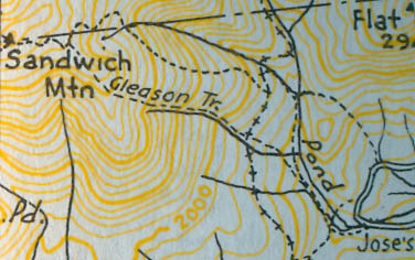
1960 AMC map of the Gleason Trail
|
|
| Links: |
|
|
|
| Last updated 2011-12-06 |
| Disclaimer: Data provided for academic and historical purposes only. Respect all signs. |
|
|
